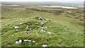
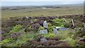
<< Our Photo Pages >> Cairn 430m NW of Craonaval - Cairn in Scotland in North Uist
Submitted by h_fenton on Thursday, 17 January 2008 Page Views: 4774
Neolithic and Bronze AgeSite Name: Cairn 430m NW of Craonaval Alternative Name: CraonabhalCountry: Scotland County: North Uist Type: Cairn
Nearest Town: Lochmaddy Nearest Village: Clachan na Luib
Map Ref: NF83236297
Latitude: 57.545479N Longitude: 7.296878W
Condition:
| 5 | Perfect |
| 4 | Almost Perfect |
| 3 | Reasonable but with some damage |
| 2 | Ruined but still recognisable as an ancient site |
| 1 | Pretty much destroyed, possibly visible as crop marks |
| 0 | No data. |
| -1 | Completely destroyed |
| 5 | Superb |
| 4 | Good |
| 3 | Ordinary |
| 2 | Not Good |
| 1 | Awful |
| 0 | No data. |
| 5 | Can be driven to, probably with disabled access |
| 4 | Short walk on a footpath |
| 3 | Requiring a bit more of a walk |
| 2 | A long walk |
| 1 | In the middle of nowhere, a nightmare to find |
| 0 | No data. |
| 5 | co-ordinates taken by GPS or official recorded co-ordinates |
| 4 | co-ordinates scaled from a detailed map |
| 3 | co-ordinates scaled from a bad map |
| 2 | co-ordinates of the nearest village |
| 1 | co-ordinates of the nearest town |
| 0 | no data |
Internal Links:
External Links:
I have visited· I would like to visit
SandyG visited on 29th Aug 2015 - their rating: Cond: 4 Amb: 5 Access: 4 Parking is available at NF 83333 63348.
h_fenton have visited here
")
You may be viewing yesterday's version of this page. To see the most up to date information please register for a free account.
")
")
")
")
Do not use the above information on other web sites or publications without permission of the contributor.
Nearby Images from Geograph Britain and Ireland:
©2021(licence)

©2009(licence)
©2021(licence)

©2009(licence)

©2021(licence)
The above images may not be of the site on this page, they are loaded from Geograph.
Please Submit an Image of this site or go out and take one for us!
Click here to see more info for this site
Nearby sites
Key: Red: member's photo, Blue: 3rd party photo, Yellow: other image, Green: no photo - please go there and take one, Grey: site destroyed
Download sites to:
KML (Google Earth)
GPX (GPS waypoints)
CSV (Garmin/Navman)
CSV (Excel)
To unlock full downloads you need to sign up as a Contributory Member. Otherwise downloads are limited to 50 sites.
Turn off the page maps and other distractions
Nearby sites listing. In the following links * = Image available
130m ESE 118° Cairn 330m NW of Craonaval* Cairn (NF83346290)
271m SSE 158° Chambered cairn 200m WNW of Craonaval* Chambered Cairn (NF83316271)
344m W 276° Loch A Phobuill* Stone Circle (NF82896303)
410m SE 135° Leac A' Mhiosachan Standing Stones (NF83506266)
644m E 94° Loch Glen Na Feannag* Chambered Cairn (NF83876288)
813m SE 135° Ultach Fhinn Standing Stone (Menhir) (NF83766235)
1.2km ESE 112° Oban Nam Fiadh* Chambered Cairn (NF84296244)
1.7km SSE 149° Possible Carved Footprints near Beinn Na Coille Carving (NF8398761447)
2.3km NNE 23° Pobull Fhinn* Stone Circle (NF84286502)
2.5km WNW 301° Cringraval* Stone Circle (NF8115364451)
2.6km WNW 299° Cringraval Stone Row Stone Row / Alignment (NF8100764413)
2.7km SSE 166° Caravat Barp* Passage Grave (NF837603)
2.7km NNE 25° Not-so-Standing Stone* Standing Stone (Menhir) (NF8459765344)
2.7km NNE 25° Beistean's Grave* Rock Art (NF8459865345)
2.8km S 176° Carinish* Stone Circle (NF83236020)
2.8km N 7° Barpa Langais* Chambered Tomb (NF8376665729)
3.0km N 5° Loch 'a Bharpa Settlement Ancient Village or Settlement (NF837659)
3.0km NE 35° East Langass Stone Circle* Stone Circle (NF85126530)
3.7km SE 140° Barp Hacklett* Chambered Cairn (NF85395993)
4.0km ESE 109° Cnoc Na File Cairn (NF869614)
4.2km W 275° Carnan nan Long* Chambered Cairn (NF79046367)
4.6km NW 316° Loch Na Buail' Iochdrach* Standing Stone (Menhir) (NF8030166524)
4.7km N 350° Airigh Na Gaoithe Long Cairn* Long Barrow (NF82796763)
4.7km NNW 348° Airigh Na Gaoithe Stone Row* Stone Row / Alignment (NF82586767)
4.9km WSW 249° Dun Na H'Ola Stone Fort or Dun (NF78546161)
View more nearby sites and additional images


 We would like to know more about this location. Please feel free to add a brief description and any relevant information in your own language.
 Wir möchten mehr über diese Stätte erfahren. Bitte zögern Sie nicht, eine kurze Beschreibung und relevante Informationen in Deutsch hinzuzufügen.
 Nous aimerions en savoir encore un peu sur les lieux. S'il vous plaît n'hesitez pas à ajouter une courte description et tous les renseignements pertinents dans votre propre langue.
 Quisieramos informarnos un poco más de las lugares. No dude en añadir una breve descripción y otros datos relevantes en su propio idioma.