<< Our Photo Pages >> Rumster Broch - Broch or Nuraghe in Scotland in Caithness
Submitted by cosmic on Monday, 01 October 2007 Page Views: 3286
Iron Age and Later PrehistorySite Name: Rumster Broch Alternative Name: ForseCountry: Scotland County: Caithness Type: Broch or Nuraghe
Nearest Village: Lybster
Map Ref: ND21253725
Latitude: 58.316720N Longitude: 3.345882W
Condition:
| 5 | Perfect |
| 4 | Almost Perfect |
| 3 | Reasonable but with some damage |
| 2 | Ruined but still recognisable as an ancient site |
| 1 | Pretty much destroyed, possibly visible as crop marks |
| 0 | No data. |
| -1 | Completely destroyed |
| 5 | Superb |
| 4 | Good |
| 3 | Ordinary |
| 2 | Not Good |
| 1 | Awful |
| 0 | No data. |
| 5 | Can be driven to, probably with disabled access |
| 4 | Short walk on a footpath |
| 3 | Requiring a bit more of a walk |
| 2 | A long walk |
| 1 | In the middle of nowhere, a nightmare to find |
| 0 | No data. |
| 5 | co-ordinates taken by GPS or official recorded co-ordinates |
| 4 | co-ordinates scaled from a detailed map |
| 3 | co-ordinates scaled from a bad map |
| 2 | co-ordinates of the nearest village |
| 1 | co-ordinates of the nearest town |
| 0 | no data |
Internal Links:
External Links:
I have visited· I would like to visit
SolarMegalith visited on 17th Jul 2011 - their rating: Cond: 2 Amb: 3 Access: 3
")
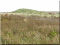
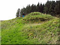
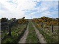
Ruined broch which now appears as a grassy mound.
You may be viewing yesterday's version of this page. To see the most up to date information please register for a free account.
")
")
")
")
Do not use the above information on other web sites or publications without permission of the contributor.
Nearby Images from Geograph Britain and Ireland:
©2008(licence)
©2010(licence)
©2008(licence)
©2012(licence)
©2012(licence)
The above images may not be of the site on this page, they are loaded from Geograph.
Please Submit an Image of this site or go out and take one for us!
Click here to see more info for this site
Nearby sites
Key: Red: member's photo, Blue: 3rd party photo, Yellow: other image, Green: no photo - please go there and take one, Grey: site destroyed
Download sites to:
KML (Google Earth)
GPX (GPS waypoints)
CSV (Garmin/Navman)
CSV (Excel)
To unlock full downloads you need to sign up as a Contributory Member. Otherwise downloads are limited to 50 sites.
Turn off the page maps and other distractions
Nearby sites listing. In the following links * = Image available
719m WNW 288° Golsary* Broch or Nuraghe (ND20573749)
1.1km SSW 206° Forse House Stone Circle* Stone Circle (ND2076136315)
1.3km S 181° Appnag Tulloch* Broch or Nuraghe (ND2121035910)
1.8km SSW 195° Usshilly Tulloch* Broch or Nuraghe (ND2075035520)
2.1km ESE 120° Rhianrivach* Broch or Nuraghe (ND23033617)
2.1km S 183° Forse House Standing Stone* Standing Stone (Menhir) (ND21093513)
2.2km SSW 199° Wag of Forse* Stone Fort or Dun (ND20483520)
2.3km SSW 195° Forse House Burnt Mounds* Artificial Mound (ND20583500)
2.4km SSW 193° Forse House Chambered Cairns* Chambered Cairn (ND20673492)
2.6km SSW 196° Forse House Hut Circles* Ancient Village or Settlement (ND205348)
2.7km ESE 114° Lybster* Early Christian Sculptured Stone (ND237361)
3.7km SSW 200° Latheron Standing Stone* Standing Stone (Menhir) (ND19923374)
3.8km SSW 198° Buldoo* Standing Stone (Menhir) (ND20003369)
3.8km SW 234° Guidebest* Stone Circle (ND181351)
4.0km SSW 198° Latheron 2* Class I Pictish Symbol Stone (ND19903343)
4.2km ESE 106° The Tullochs* Broch or Nuraghe (ND25293597)
4.8km SSW 212° Latheronwheel Stone Circle (ND186332)
4.9km SW 224° Smerral Broch or Nuraghe (ND17803379)
5.1km NNW 331° Achkinloch* Chambered Cairn (ND18874172)
5.1km NNW 330° Achavanich* Stone Circle (ND1878841772)
5.5km NW 322° Greystell Castle* Broch or Nuraghe (ND17954167)
5.9km ESE 105° Occumster* Broch or Nuraghe (ND26933565)
6.0km SW 216° Latheronwheel Mains Broch or Nuraghe (ND17623251)
6.0km ENE 63° Greenhill Broch Broch or Nuraghe (ND26643986)
6.0km E 89° Bardintulloch Broch or Nuraghe (ND27303727)
View more nearby sites and additional images


 We would like to know more about this location. Please feel free to add a brief description and any relevant information in your own language.
 Wir möchten mehr über diese Stätte erfahren. Bitte zögern Sie nicht, eine kurze Beschreibung und relevante Informationen in Deutsch hinzuzufügen.
 Nous aimerions en savoir encore un peu sur les lieux. S'il vous plaît n'hesitez pas à ajouter une courte description et tous les renseignements pertinents dans votre propre langue.
 Quisieramos informarnos un poco más de las lugares. No dude en añadir una breve descripción y otros datos relevantes en su propio idioma.