 with our Megalithic Portal iPhone app")

<< Our Photo Pages >> Wrack Huegelgrab 3 - Round Barrow(s) in Germany in Schleswig-Holstein, Hamburg
Submitted by holger_rix on Thursday, 13 September 2007 Page Views: 1985
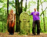
Neolithic and Bronze AgeSite Name: Wrack Huegelgrab 3Country: Germany Land: Schleswig-Holstein, Hamburg Type: Round Barrow(s)
Nearest Village: Oeschebuettel
Latitude: 53.991953N Longitude: 9.703956E
Condition:
| 5 | Perfect |
| 4 | Almost Perfect |
| 3 | Reasonable but with some damage |
| 2 | Ruined but still recognisable as an ancient site |
| 1 | Pretty much destroyed, possibly visible as crop marks |
| 0 | No data. |
| -1 | Completely destroyed |
| 5 | Superb |
| 4 | Good |
| 3 | Ordinary |
| 2 | Not Good |
| 1 | Awful |
| 0 | No data. |
| 5 | Can be driven to, probably with disabled access |
| 4 | Short walk on a footpath |
| 3 | Requiring a bit more of a walk |
| 2 | A long walk |
| 1 | In the middle of nowhere, a nightmare to find |
| 0 | No data. |
| 5 | co-ordinates taken by GPS or official recorded co-ordinates |
| 4 | co-ordinates scaled from a detailed map |
| 3 | co-ordinates scaled from a bad map |
| 2 | co-ordinates of the nearest village |
| 1 | co-ordinates of the nearest town |
| 0 | no data |
Internal Links:
External Links:
")
You may be viewing yesterday's version of this page. To see the most up to date information please register for a free account.
Do not use the above information on other web sites or publications without permission of the contributor.
Nearby Images from Flickr


The above images may not be of the site on this page, but were taken nearby. They are loaded from Flickr so please click on them for image credits.
Click here to see more info for this site
Nearby sites
Click here to view sites on an interactive map of the areaKey: Red: member's photo, Blue: 3rd party photo, Yellow: other image, Green: no photo - please go there and take one, Grey: site destroyed
Download sites to:
KML (Google Earth)
GPX (GPS waypoints)
CSV (Garmin/Navman)
CSV (Excel)
To unlock full downloads you need to sign up as a Contributory Member. Otherwise downloads are limited to 50 sites.
Turn off the page maps and other distractions
Nearby sites listing. In the following links * = Image available
857m SSE 163° Wrack Huegelgrab 1* Round Barrow(s)
866m SSE 157° Wrack Huegelgrab 2* Round Barrow(s)
1.0km SW 233° Oeschebuettel Huegelgrab 1* Round Barrow(s)
3.0km WSW 249° Springhoe Huegelgrab 1* Round Barrow(s)
3.6km SE 131° Stoerkathen Huegelgrab* Round Barrow(s)
4.0km SSE 157° Kellinghusen Huegelgrab* Round Barrow(s)
5.1km SW 229° Hohenlockstedt Huegelgrab 2* Round Barrow(s)
5.2km SW 231° Hohenlockstedt Huegelgrab 1* Round Barrow(s)
6.9km ENE 73° Willenscharen Ringwallburg* Hillfort
7.8km NNE 30° Aukrug (Tönsheide)* Round Barrow(s)
8.0km SE 144° Wrist Huegelgrab* Round Barrow(s)
9.0km SE 138° Foehrden-Barl Huegelgrab 1* Round Barrow(s)
9.3km NE 38° Aukrug-Bargfeld* Barrow Cemetery
9.3km SE 137° Foehrden-Barl Huegelgrab 2* Round Barrow(s)
9.4km NNW 339° Jahrsdorf Huegelgraebergruppe* Round Barrow(s)
9.9km NNE 24° Grabhuegelgruppe Aukrug* Round Barrow(s)
10.5km WSW 238° Winseldorf Huegelgrab* Round Barrow(s)
11.0km NE 46° Dithmarsische Berge* Round Barrow(s)
11.1km NE 43° Aukrug-Bünzen* Barrow Cemetery
11.2km SW 230° Oelixdorf Huegelgrab* Round Barrow(s)
11.3km NNW 344° Hohenwestedt Schalenstein* Rock Art
12.2km WSW 240° Itzehoe Grabhuegelgruppe 1* Barrow Cemetery
12.4km WSW 243° Itzehoe Grabhuegelgruppe 2* Barrow Cemetery
12.6km SSE 158° Moenkloh Grabhuegelgruppen* Barrow Cemetery
13.0km ENE 58° Wasbek West Huegelgrab* Barrow Cemetery
View more nearby sites and additional images


 We would like to know more about this location. Please feel free to add a brief description and any relevant information in your own language.
 Wir möchten mehr über diese Stätte erfahren. Bitte zögern Sie nicht, eine kurze Beschreibung und relevante Informationen in Deutsch hinzuzufügen.
 Nous aimerions en savoir encore un peu sur les lieux. S'il vous plaît n'hesitez pas à ajouter une courte description et tous les renseignements pertinents dans votre propre langue.
 Quisieramos informarnos un poco más de las lugares. No dude en añadir una breve descripción y otros datos relevantes en su propio idioma.