


<< Our Photo Pages >> The Winking Man - Natural Stone / Erratic / Other Natural Feature in England in Staffordshire
Submitted by TimPrevett on Tuesday, 07 November 2006 Page Views: 32939
Natural PlacesSite Name: The Winking ManCountry: England County: Staffordshire Type: Natural Stone / Erratic / Other Natural Feature
Nearest Town: Leek Nearest Village: Thorncliffe
Map Ref: SK0202162362
Latitude: 53.158383N Longitude: 1.971231W
Condition:
| 5 | Perfect |
| 4 | Almost Perfect |
| 3 | Reasonable but with some damage |
| 2 | Ruined but still recognisable as an ancient site |
| 1 | Pretty much destroyed, possibly visible as crop marks |
| 0 | No data. |
| -1 | Completely destroyed |
| 5 | Superb |
| 4 | Good |
| 3 | Ordinary |
| 2 | Not Good |
| 1 | Awful |
| 0 | No data. |
| 5 | Can be driven to, probably with disabled access |
| 4 | Short walk on a footpath |
| 3 | Requiring a bit more of a walk |
| 2 | A long walk |
| 1 | In the middle of nowhere, a nightmare to find |
| 0 | No data. |
| 5 | co-ordinates taken by GPS or official recorded co-ordinates |
| 4 | co-ordinates scaled from a detailed map |
| 3 | co-ordinates scaled from a bad map |
| 2 | co-ordinates of the nearest village |
| 1 | co-ordinates of the nearest town |
| 0 | no data |
Internal Links:
External Links:
I have visited· I would like to visit
Ballhc saw from a distance on 17th Jan 2015
BrownEdger visited on 14th Aug 2010 - their rating: Cond: 4 Amb: 5 Access: 4
TimPrevett have visited here
")
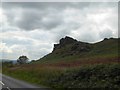
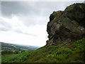
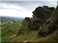
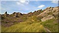
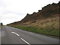
Parking is to west of the Rocks (good layby at SK 01746 62012), then a fairly easy walk up to near the summit, and the Winking Man is on the east side. Tripping hazards, free slots and drops abound - so take care. The nearby Winking Man pub have put up a webcam.
The place heaves with rock climbers and ramblers at the weekends and holidays, so do as I did and get there for sunrise on a clear morning. Magic.
You may be viewing yesterday's version of this page. To see the most up to date information please register for a free account.
")
")
")
Do not use the above information on other web sites or publications without permission of the contributor.
Nearby Images from Geograph Britain and Ireland:
©2017(licence)
©2009(licence)
©2009(licence)
©2016(licence)
©2009(licence)
The above images may not be of the site on this page, they are loaded from Geograph.
Please Submit an Image of this site or go out and take one for us!
Click here to see more info for this site
Nearby sites
Key: Red: member's photo, Blue: 3rd party photo, Yellow: other image, Green: no photo - please go there and take one, Grey: site destroyed
Download sites to:
KML (Google Earth)
GPX (GPS waypoints)
CSV (Garmin/Navman)
CSV (Excel)
To unlock full downloads you need to sign up as a Contributory Member. Otherwise downloads are limited to 50 sites.
Turn off the page maps and other distractions
Nearby sites listing. In the following links * = Image available
1.3km WSW 253° Bawd Stone* Natural Stone / Erratic / Other Natural Feature (SK0079561976)
1.3km WSW 249° Sainter's Circle* Stone Circle (SK008619)
1.5km WSW 248° The Roaches* Natural Stone / Erratic / Other Natural Feature (SK006618)
1.8km N 353° The Bald Stone* Natural Stone / Erratic / Other Natural Feature (SK018641)
2.3km WNW 302° Sainter's Dolmen* Rock Outcrop (SK00106357)
2.5km NW 309° The Roaches Barrow Round Barrow(s) (SK001639)
2.5km ESE 123° Merryton Low 1* Round Barrow(s) (SK041610)
2.6km SE 130° Merryton Low 2* Round Barrow(s) (SK040607)
2.6km SW 221° Leekfrith Tumulus* Round Barrow(s) (SK003604)
2.8km SW 226° Leekfrith Stone* Standing Stone (Menhir) (SK000604)
4.0km S 176° Thorncliffe Barrow Round Barrow(s) (SK023584)
4.5km NNW 334° Roaches Stone carving* Carving (SK00076637)
4.6km NW 314° Lud's Church* Natural Stone / Erratic / Other Natural Feature (SJ987656)
4.6km N 360° Flash Chambered Tomb (SK0267)
4.9km SE 141° Elkstone Barrow 1* Round Barrow(s) (SK05155855)
5.0km SE 141° Elkstone Barrow 2 Round Barrow(s) (SK052585)
5.1km SW 225° Nine Pins* Stone Circle (SJ984587)
5.2km WSW 257° Gun Hill Standing Stone* Standing Stone (Menhir) (SJ969612)
5.8km NE 47° Coatestown Barrow Round Barrow(s) (SK063663)
6.5km WNW 300° Bartomley Farm* Long Barrow (SJ964656)
6.5km W 275° Heaton Low* Round Barrow(s) (SJ955629)
6.6km NW 309° Allgreave* Standing Stone (Menhir) (SJ969665)
6.7km NNE 25° Brand End standing stones* Standing Stones (SK0488868373)
6.7km SSW 211° Nicholson Museum and Art Gallery* Museum (SJ985566)
6.8km E 84° Booth Low 1* Round Barrow(s) (SK088631)
View more nearby sites and additional images


 We would like to know more about this location. Please feel free to add a brief description and any relevant information in your own language.
 Wir möchten mehr über diese Stätte erfahren. Bitte zögern Sie nicht, eine kurze Beschreibung und relevante Informationen in Deutsch hinzuzufügen.
 Nous aimerions en savoir encore un peu sur les lieux. S'il vous plaît n'hesitez pas à ajouter une courte description et tous les renseignements pertinents dans votre propre langue.
 Quisieramos informarnos un poco más de las lugares. No dude en añadir una breve descripción y otros datos relevantes en su propio idioma.