


<< Our Photo Pages >> Monk's Well (Balmerino) - Holy Well or Sacred Spring in Scotland in Fife
Submitted by KiwiBetsy on Wednesday, 27 September 2006 Page Views: 7189
Springs and Holy WellsSite Name: Monk's Well (Balmerino)Country: Scotland County: Fife Type: Holy Well or Sacred Spring
Map Ref: NO358247
Latitude: 56.410151N Longitude: 3.042013W
Condition:
| 5 | Perfect |
| 4 | Almost Perfect |
| 3 | Reasonable but with some damage |
| 2 | Ruined but still recognisable as an ancient site |
| 1 | Pretty much destroyed, possibly visible as crop marks |
| 0 | No data. |
| -1 | Completely destroyed |
| 5 | Superb |
| 4 | Good |
| 3 | Ordinary |
| 2 | Not Good |
| 1 | Awful |
| 0 | No data. |
| 5 | Can be driven to, probably with disabled access |
| 4 | Short walk on a footpath |
| 3 | Requiring a bit more of a walk |
| 2 | A long walk |
| 1 | In the middle of nowhere, a nightmare to find |
| 0 | No data. |
| 5 | co-ordinates taken by GPS or official recorded co-ordinates |
| 4 | co-ordinates scaled from a detailed map |
| 3 | co-ordinates scaled from a bad map |
| 2 | co-ordinates of the nearest village |
| 1 | co-ordinates of the nearest town |
| 0 | no data |
Internal Links:
External Links:
 (PID:24426)")
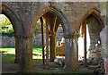
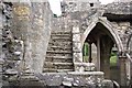
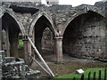
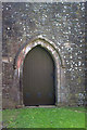
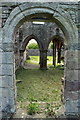
Although little seems to be known of it’s history, this very nice little well was closely associated with Balmerino Abbey and it’s monks.
The Monks' Well lies a short distance northeast of the abbey ruins, very close to the north bank of a small steam and in very marshy ground. It is a small stone lined compartment with a very healthy water flow.
You may be viewing yesterday's version of this page. To see the most up to date information please register for a free account.
 (PID:24427)")
Do not use the above information on other web sites or publications without permission of the contributor.
Nearby Images from Geograph Britain and Ireland:
©2011(licence)
©2008(licence)
©2005(licence)
©2013(licence)
©2013(licence)
The above images may not be of the site on this page, they are loaded from Geograph.
Please Submit an Image of this site or go out and take one for us!
Click here to see more info for this site
Nearby sites
Key: Red: member's photo, Blue: 3rd party photo, Yellow: other image, Green: no photo - please go there and take one, Grey: site destroyed
Download sites to:
KML (Google Earth)
GPX (GPS waypoints)
CSV (Garmin/Navman)
CSV (Excel)
To unlock full downloads you need to sign up as a Contributory Member. Otherwise downloads are limited to 50 sites.
Turn off the page maps and other distractions
Nearby sites listing. In the following links * = Image available
4.4km ESE 117° Kilmany Cursus Cursus (NO39742263)
4.7km SSE 153° Lochmaloney Farmm (Kilmany) Rock Art (NO37902049)
5.4km SW 226° Creich Manse* Class I Pictish Symbol Stone (NO319210)
5.4km NNW 348° St Peter's Church (Invergowrie)* Early Christian Sculptured Stone (NO348300)
5.9km NNW 335° Mylnefield Stone Circle (NO334301)
6.3km N 3° Dark Stane Roundie* Round Barrow(s) (NO362310)
6.4km NNW 344° Longforgan Cursus Cursus (NO34123090)
6.4km NNW 348° Devil's Stone (Perth & Kinross)* Standing Stone (Menhir) (NO3458131019)
6.4km NNW 344° Longforgan Cursus Cursus (NO34163094)
6.9km N 355° Balgarthno* Stone Circle (NO35333161)
7.3km NE 37° McManus Galleries* Museum (NO40253047)
8.2km N 357° Camperdown Standing Stone* Standing Stone (Menhir) (NO3549632905)
8.3km NW 318° Longforgan Cursus Cursus (NO30353100)
8.5km NNW 341° Hurly Hawkins* Broch or Nuraghe (NO332328)
8.8km NW 314° Falcon Stone* Standing Stone (Menhir) (NO295309)
8.8km WNW 302° Moncur Castle* Standing Stone (Menhir) (NO2836929520)
8.9km NW 312° Rossie Mercat Cross 1746 Ancient Cross (NO2920830732)
8.9km NW 312° Rossie Loupin-on Stane* Standing Stone (Menhir) (NO2917630741)
9.0km NW 312° Rossie Priory Class II Pictish Symbol Stone (NO292308)
9.5km NNW 345° Liff and Benvie Cursus Cursus (NO33403391)
9.6km NNW 344° Liff and Benvie Cursus Cursus (NO33263396)
10.0km ESE 108° St Bunyan's Well (Leuchars) Holy Well or Sacred Spring (NO4525221483)
10.0km WNW 286° Inchmartine House* Standing Stone (Menhir) (NO26152759)
10.2km ESE 107° Lady's Well (Leuchars) Holy Well or Sacred Spring (NO4557321645)
10.7km N 10° Strathmartine 3 Class II Pictish Symbol Stone (NO378352)
View more nearby sites and additional images


 We would like to know more about this location. Please feel free to add a brief description and any relevant information in your own language.
 Wir möchten mehr über diese Stätte erfahren. Bitte zögern Sie nicht, eine kurze Beschreibung und relevante Informationen in Deutsch hinzuzufügen.
 Nous aimerions en savoir encore un peu sur les lieux. S'il vous plaît n'hesitez pas à ajouter une courte description et tous les renseignements pertinents dans votre propre langue.
 Quisieramos informarnos un poco más de las lugares. No dude en añadir una breve descripción y otros datos relevantes en su propio idioma.