


<< Our Photo Pages >> Black Park - Standing Stone (Menhir) in England in Yorkshire (North)
Submitted by kelpie on Tuesday, 11 May 2004 Page Views: 7481
Neolithic and Bronze AgeSite Name: Black Park Alternative Name: Black Park Standing StoneCountry: England County: Yorkshire (North) Type: Standing Stone (Menhir)
Nearest Town: Pickering Nearest Village: Cropton
Map Ref: SE753909 Landranger Map Number: 94
Latitude: 54.308158N Longitude: 0.844198W
Condition:
| 5 | Perfect |
| 4 | Almost Perfect |
| 3 | Reasonable but with some damage |
| 2 | Ruined but still recognisable as an ancient site |
| 1 | Pretty much destroyed, possibly visible as crop marks |
| 0 | No data. |
| -1 | Completely destroyed |
| 5 | Superb |
| 4 | Good |
| 3 | Ordinary |
| 2 | Not Good |
| 1 | Awful |
| 0 | No data. |
| 5 | Can be driven to, probably with disabled access |
| 4 | Short walk on a footpath |
| 3 | Requiring a bit more of a walk |
| 2 | A long walk |
| 1 | In the middle of nowhere, a nightmare to find |
| 0 | No data. |
| 5 | co-ordinates taken by GPS or official recorded co-ordinates |
| 4 | co-ordinates scaled from a detailed map |
| 3 | co-ordinates scaled from a bad map |
| 2 | co-ordinates of the nearest village |
| 1 | co-ordinates of the nearest town |
| 0 | no data |
Internal Links:
External Links:
I have visited· I would like to visit
kelpie has visited here
")
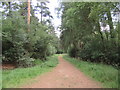
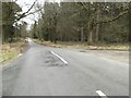
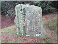
This short standing stone is hidden among a forestry plantation and can be difficult to find. The minor road leading to Spiers House passes through some low earthworks, if these are followed to the east the standing stone is in direct alignment with them.
You may be viewing yesterday's version of this page. To see the most up to date information please register for a free account.
")
")
")
")
Do not use the above information on other web sites or publications without permission of the contributor.
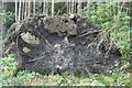
Nearby Images from Geograph Britain and Ireland:
©2011(licence)
©2019(licence)
©2023(licence)
©2022(licence)
©2012(licence)
The above images may not be of the site on this page, they are loaded from Geograph.
Please Submit an Image of this site or go out and take one for us!
Click here to see more info for this site
Nearby sites
Key: Red: member's photo, Blue: 3rd party photo, Yellow: other image, Green: no photo - please go there and take one, Grey: site destroyed
Download sites to:
KML (Google Earth)
GPX (GPS waypoints)
CSV (Garmin/Navman)
CSV (Excel)
To unlock full downloads you need to sign up as a Contributory Member. Otherwise downloads are limited to 50 sites.
![]()
Turn off the page maps and other distractions
Nearby sites listing. In the following links * = Image available
1.7km S 170° Cropton Cross* Ancient Cross (SE7562689277)
2.4km W 262° St Chad's Well (Lastingham)* Holy Well or Sacred Spring (SE7296390542)
2.4km W 260° St Cedd's Well* Holy Well or Sacred Spring (SE7291990460)
2.5km NNW 328° Abrahams Hut (Spaunton Moor)* Round Cairn (SE7394093016)
2.5km W 261° St Mary (Lastingham)* Ancient Cross (SE72819045)
2.6km ESE 109° Cawthorn Cart Burial Misc. Earthwork (SE778901)
2.8km ESE 114° Cawthorne Banks Tumulus* Cairn (SE779898)
3.0km SW 221° High Cross (Appleton Le Moors)* Ancient Cross (SE7335888560)
3.1km W 262° Mary Magdalene's Well* Holy Well or Sacred Spring (SE722904)
3.3km SW 216° Low Cross (Appleton Le Moors)* Ancient Cross (SE7342188200)
3.3km ESE 109° Cawthorne Square Barrow* Round Barrow(s) (SE78458987)
3.4km NW 322° Redman Cross* Ancient Cross (SE7315893568)
4.1km NW 317° Ana Cross Round Barrow and Wayside Cross* Round Barrow(s) (SE7247393823)
4.4km NE 39° Leaf Howe* Barrow Cemetery (SE780944)
4.5km NE 36° High Muffles Tumulus* Round Barrow(s) (SE7789694630)
4.6km E 87° Rawcliffe Howe* Cairn (SE799912)
4.8km S 189° Sinnington Crosses* Ancient Cross (SE746861)
4.8km W 261° Ryedale Folk Museum* Museum (SE7051890022)
5.1km WNW 293° High Snape's ring cairn* Ring Cairn (SE706928)
5.2km NE 54° Old Wives' Well* Holy Well or Sacred Spring (SE7943894057)
5.3km E 91° Black Howe (Rawcliffe)* Cairn (SE80599087)
5.3km NW 318° Three Howes (Blakey)* Barrow Cemetery (SE71669475)
5.5km W 280° Slap Stones Wath RC1* Round Cairn (SE6986791732)
5.5km NE 52° Mauley Cross* Ancient Cross (SE796944)
5.6km SSW 210° Sinnington Round Barrow* Round Barrow(s) (SE7255686032)
View more nearby sites and additional images


 We would like to know more about this location. Please feel free to add a brief description and any relevant information in your own language.
 Wir möchten mehr über diese Stätte erfahren. Bitte zögern Sie nicht, eine kurze Beschreibung und relevante Informationen in Deutsch hinzuzufügen.
 Nous aimerions en savoir encore un peu sur les lieux. S'il vous plaît n'hesitez pas à ajouter une courte description et tous les renseignements pertinents dans votre propre langue.
 Quisieramos informarnos un poco más de las lugares. No dude en añadir una breve descripción y otros datos relevantes en su propio idioma.