 with our Megalithic Portal iPhone app")

<< Our Photo Pages >> Anta Da Chaminé - Burial Chamber or Dolmen in Portugal in Évora
Submitted by AlexHunger on Thursday, 27 April 2006 Page Views: 2809
Neolithic and Bronze AgeSite Name: Anta Da ChaminéCountry: Portugal Distrito: Évora Type: Burial Chamber or Dolmen
Nearest Town: Montemor-o-Novo Nearest Village: São Geraldo
Latitude: 38.751670N Longitude: 8.178542W
Condition:
| 5 | Perfect |
| 4 | Almost Perfect |
| 3 | Reasonable but with some damage |
| 2 | Ruined but still recognisable as an ancient site |
| 1 | Pretty much destroyed, possibly visible as crop marks |
| 0 | No data. |
| -1 | Completely destroyed |
| 5 | Superb |
| 4 | Good |
| 3 | Ordinary |
| 2 | Not Good |
| 1 | Awful |
| 0 | No data. |
| 5 | Can be driven to, probably with disabled access |
| 4 | Short walk on a footpath |
| 3 | Requiring a bit more of a walk |
| 2 | A long walk |
| 1 | In the middle of nowhere, a nightmare to find |
| 0 | No data. |
| 5 | co-ordinates taken by GPS or official recorded co-ordinates |
| 4 | co-ordinates scaled from a detailed map |
| 3 | co-ordinates scaled from a bad map |
| 2 | co-ordinates of the nearest village |
| 1 | co-ordinates of the nearest town |
| 0 | no data |
Internal Links:
External Links:
I have visited· I would like to visit
Bak_teria visited on 27th Sep 2014 - their rating: Cond: 4 Amb: 4 Access: 3
Ana visited on 27th Sep 2014 - their rating: Cond: 3 Amb: 4 Access: 4
Average ratings for this site from all visit loggers: Condition: 3.5 Ambience: 4 Access: 3.5
")
From Bak_teria:
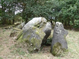
The Anta of Chaminé is located in the hill of Chamíné in Nossa Senhora do Bispo, in the county of Montemor-o-Novo of the Évora district. It is believed that has been built around 4000 or 3000 B.C. It fits chronologically in the general type of constructions of the Évora Megalithism. This monument is still waiting to be classified as heritage.
About the architecture
The dolmen consists of a burial chamber with little more than 2.5 meters (8.2 feet) in diameter whose original structure still stand in situ. Is made of seven granite pillars and still has got the top slab. The corridor which is oriented to the east keeps four pillars on the south side and two on the north side and is about 0.8 metres (2.6 feet) tall. Shows no traces of the mound or of the coverage of the corridor that should have been 2.4 metres long (7.8 feet) in the past. It also presents eight dimples engraved on the top face of the hat slab.
About the location
You can get there by walking or driving in a dirt road located between São Geraldo and Sabugueiro. This dirt track goes to the hill of Bate Pé and when you go 1.3 Km (0.8 miles) you will notice that the dolmen is located 200 metres at the right side and is visible next to some cork and holm oaks.
Links
- IGESPAR
- Information in the Website of the county of Montemor-o-Novo.
You may be viewing yesterday's version of this page. To see the most up to date information please register for a free account.
")
")
Do not use the above information on other web sites or publications without permission of the contributor.
Nearby Images from Flickr


The above images may not be of the site on this page, but were taken nearby. They are loaded from Flickr so please click on them for image credits.
Click here to see more info for this site
Nearby sites
Click here to view sites on an interactive map of the areaKey: Red: member's photo, Blue: 3rd party photo, Yellow: other image, Green: no photo - please go there and take one, Grey: site destroyed
Download sites to:
KML (Google Earth)
GPX (GPS waypoints)
CSV (Garmin/Navman)
CSV (Excel)
To unlock full downloads you need to sign up as a Contributory Member. Otherwise downloads are limited to 50 sites.
Turn off the page maps and other distractions
Nearby sites listing. In the following links * = Image available
1.1km N 352° Anta Da Comenda Grande* Burial Chamber or Dolmen
1.3km W 280° Anta Da Rapoula 2 Burial Chamber or Dolmen
1.4km WNW 282° Anta Da Rapoula 1 Burial Chamber or Dolmen
1.7km SSW 207° Anta Dos Varelas 1 Burial Chamber or Dolmen
2.0km NW 318° Anta do Estanque* Burial Chamber or Dolmen
2.2km WNW 288° Anta Grande da Comenda da Igreja* Burial Chamber or Dolmen
2.5km WNW 303° Anta Pequena da Comenda da Igreja* Burial Chamber or Dolmen
2.7km SE 145° Anta Do Bate Pé Velho 1 Burial Chamber or Dolmen
2.8km W 278° Anta Da Velada Burial Chamber or Dolmen
2.9km SE 142° Anta Do Bate Pé Velho 2 Burial Chamber or Dolmen
2.9km SE 141° Anta Do Bate Pé Velho 3 Burial Chamber or Dolmen
3.5km SE 129° Anta Do Carvalho 2 Burial Chamber or Dolmen
3.6km NNW 334° Agua Doce 1 Burial Chamber or Dolmen
3.8km S 172° Anta Dos Varelas 2 Burial Chamber or Dolmen
4.0km NW 322° Anta De Vale De Cancelas* Burial Chamber or Dolmen
4.0km WNW 294° Anta Do Rocio Do Montinho Burial Chamber or Dolmen
4.0km NW 321° Menires De Vale De Cancelas* Standing Stones
4.0km SE 125° Anta Do Carvalho 1 Burial Chamber or Dolmen
4.1km WNW 302° Anta do Paço 1* Burial Chamber or Dolmen
4.2km WNW 302° Anta do Paço 2* Burial Chamber or Dolmen
4.6km WNW 296° Anta Do Zambujeiro Burial Chamber or Dolmen
4.8km SW 215° Anta Da Fonte Santa (Rabaçal) Burial Chamber or Dolmen
4.9km SE 126° Anta Dos Nabos Burial Chamber or Dolmen
5.8km WSW 241° Anta Da Murteira 2 Burial Chamber or Dolmen
7.4km SW 223° Anta De Alfundões Burial Chamber or Dolmen
View more nearby sites and additional images


 We would like to know more about this location. Please feel free to add a brief description and any relevant information in your own language.
 Wir möchten mehr über diese Stätte erfahren. Bitte zögern Sie nicht, eine kurze Beschreibung und relevante Informationen in Deutsch hinzuzufügen.
 Nous aimerions en savoir encore un peu sur les lieux. S'il vous plaît n'hesitez pas à ajouter une courte description et tous les renseignements pertinents dans votre propre langue.
 Quisieramos informarnos un poco más de las lugares. No dude en añadir una breve descripción y otros datos relevantes en su propio idioma.