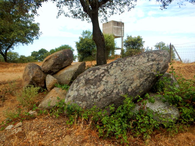
<< Our Photo Pages >> Cromeleque de Cuncos - Stone Circle in Portugal in Évora
Submitted by Magalhaes on Friday, 14 April 2006 Page Views: 5607
Neolithic and Bronze AgeSite Name: Cromeleque de Cuncos Alternative Name: Recinto Dos CuncosCountry: Portugal Distrito: Évora Type: Stone Circle
Nearest Town: Montemor-O-Novo
Latitude: 38.645090N Longitude: 8.291068W
Condition:
| 5 | Perfect |
| 4 | Almost Perfect |
| 3 | Reasonable but with some damage |
| 2 | Ruined but still recognisable as an ancient site |
| 1 | Pretty much destroyed, possibly visible as crop marks |
| 0 | No data. |
| -1 | Completely destroyed |
| 5 | Superb |
| 4 | Good |
| 3 | Ordinary |
| 2 | Not Good |
| 1 | Awful |
| 0 | No data. |
| 5 | Can be driven to, probably with disabled access |
| 4 | Short walk on a footpath |
| 3 | Requiring a bit more of a walk |
| 2 | A long walk |
| 1 | In the middle of nowhere, a nightmare to find |
| 0 | No data. |
| 5 | co-ordinates taken by GPS or official recorded co-ordinates |
| 4 | co-ordinates scaled from a detailed map |
| 3 | co-ordinates scaled from a bad map |
| 2 | co-ordinates of the nearest village |
| 1 | co-ordinates of the nearest town |
| 0 | no data |
Internal Links:
External Links:
I have visited· I would like to visit
Ana visited on 16th Aug 2014 - their rating: Cond: 2 Amb: 2 Access: 5
Bak_teria visited on 16th Aug 2014 - their rating: Cond: 2 Amb: 2 Access: 5
Magalhaes have visited here
Average ratings for this site from all visit loggers: Condition: 2 Ambience: 2 Access: 5

About the architecture
Although partially destroyed, this megalithic monument was originally composed of a circular enclosure with about thirteen and a half meters in diameter, made up of eight large granite monoliths, in the center of which, used to stand three menhirs of phallic configuration, with a variable height between two and a half and four meters tall. Its destruction may be due to agricultural work in the area.
About the artefacts and other findings
In 1985 was promoted a most comprehensive study in order to facilitate their subsequent conservation and possible restoration, including the restitution in their deployment holes all the fallen menhir stones. During this survey was possible to identify some lithic pieces and fragments of strikers, in addition to another menhir stone and other artefacts. Unfortunately the monument remains in a very decrepit state and its situation is getting worse day by day.
About the access and condition
On the road from Montemor-O-Novo to Vendas Novas, after 6 km, at the Courela do Guita vineyard (where you can also see the Casas Novas, or Courela do Guita, menhir behind the houses), turn back; take the first dirt road to the right, between the vineyard and the sparse tree land; after a water tower, the stones are on a low hill on the right.
The tourism brochure refers 11 stones, but in 2004 I found no more than half a dozen fallen, rounded ones.
A very few metres west there are the possible remains of houses.
Links and information sources (all texts written in Portuguese):
- IGESPAR
- Portal do Arqueólogo
Aditional information:
- You are entering in private property but the access is possible.
- The entrance to the zone of the monuments may be blocked by fences, they were essentially made to demarcate the land and not allow the escape of livestock. Usually there are spaces in the fences within these demarcated areas where the access is possible. When entering in demarcated land never forget to close the access gate of the location, you need to be very aware because cattle can escape.
- There are no signs prohibiting us from entering so the access can be open but be careful when you explore every time you see this red plaques that alert you for the Hunting Zones. Remind yourself that usually hunters can only hunt at selected hunting days (Thursdays, Sundays and on public holidays).
Note: Original text about the access and condition by Magalhaes, aditional and recent text by Bak_teria.
You may be viewing yesterday's version of this page. To see the most up to date information please register for a free account.


Do not use the above information on other web sites or publications without permission of the contributor.
Click here to see more info for this site
Nearby sites
Click here to view sites on an interactive map of the areaKey: Red: member's photo, Blue: 3rd party photo, Yellow: other image, Green: no photo - please go there and take one, Grey: site destroyed
Download sites to:
KML (Google Earth)
GPX (GPS waypoints)
CSV (Garmin/Navman)
CSV (Excel)
To unlock full downloads you need to sign up as a Contributory Member. Otherwise downloads are limited to 50 sites.
Turn off the page maps and other distractions
Nearby sites listing. In the following links * = Image available
448m NNW 342° Menir da Courela da Casa Nova* Standing Stone (Menhir)
1.3km SSE 158° Recinto Do Sideral* Stone Circle
1.5km SE 141° Menir Do Sideral Standing Stone (Menhir)
2.3km SE 141° Menir Da Sobreira Standing Stone (Menhir)
6.8km E 92° Museu Arqueológico de Montemor-o-Novo* Museum
7.1km NNE 20° Anta Do Vidigal Burial Chamber or Dolmen
7.5km NE 39° Anta De Cabeço De Mouro Burial Chamber or Dolmen
7.6km N 7° Anta Da Amendoeira 1 Burial Chamber or Dolmen
7.8km NNE 20° Anta Da Murteira Burial Chamber or Dolmen
8.0km NE 36° Anta De Alfundões Burial Chamber or Dolmen
8.1km SSW 200° Anta Dos Castelos 1 Burial Chamber or Dolmen
10.0km NNE 14° Anta Da Atalaia Burial Chamber or Dolmen
10.1km NNW 346° Anta De Ribeira De Pegos Burial Chamber or Dolmen
10.2km NNE 27° Anta Da Murteira 2 Burial Chamber or Dolmen
10.6km NE 42° Anta Da Fonte Santa (Rabaçal) Burial Chamber or Dolmen
10.8km E 90° Anta Dos Tourais 2* Burial Chamber or Dolmen
11.0km E 84° Anta Da Amoreira Da Torre* Burial Chamber or Dolmen
11.1km SSW 208° Anta De Vale Da Asna 1 Burial Chamber or Dolmen
11.5km E 91° Anta dos Tourais 1* Burial Chamber or Dolmen
12.2km N 2° Anta Do Foro 1 Burial Chamber or Dolmen
12.2km SSE 147° Anta da Malhada 2 Burial Chamber or Dolmen
12.2km SSW 205° Anta De Vale Da Asna 2 Burial Chamber or Dolmen
12.5km N 1° Anta Do Foro 2 Burial Chamber or Dolmen
13.0km SSE 147° Anta da Malhada 1 Burial Chamber or Dolmen
13.1km NE 52° Anta Dos Varelas 2 Burial Chamber or Dolmen
View more nearby sites and additional images


 We would like to know more about this location. Please feel free to add a brief description and any relevant information in your own language.
 Wir möchten mehr über diese Stätte erfahren. Bitte zögern Sie nicht, eine kurze Beschreibung und relevante Informationen in Deutsch hinzuzufügen.
 Nous aimerions en savoir encore un peu sur les lieux. S'il vous plaît n'hesitez pas à ajouter une courte description et tous les renseignements pertinents dans votre propre langue.
 Quisieramos informarnos un poco más de las lugares. No dude en añadir una breve descripción y otros datos relevantes en su propio idioma.