

<< Our Photo Pages >> Txoritokieta - Standing Stone (Menhir) in Spain in Pais Vasco
Submitted by irundarra on Sunday, 26 February 2006 Page Views: 3083
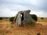
Neolithic and Bronze AgeSite Name: TxoritokietaCountry: Spain Region: Pais Vasco Type: Standing Stone (Menhir)
Latitude: 43.289674N Longitude: 1.920414W
Condition:
| 5 | Perfect |
| 4 | Almost Perfect |
| 3 | Reasonable but with some damage |
| 2 | Ruined but still recognisable as an ancient site |
| 1 | Pretty much destroyed, possibly visible as crop marks |
| 0 | No data. |
| -1 | Completely destroyed |
| 5 | Superb |
| 4 | Good |
| 3 | Ordinary |
| 2 | Not Good |
| 1 | Awful |
| 0 | No data. |
| 5 | Can be driven to, probably with disabled access |
| 4 | Short walk on a footpath |
| 3 | Requiring a bit more of a walk |
| 2 | A long walk |
| 1 | In the middle of nowhere, a nightmare to find |
| 0 | No data. |
| 5 | co-ordinates taken by GPS or official recorded co-ordinates |
| 4 | co-ordinates scaled from a detailed map |
| 3 | co-ordinates scaled from a bad map |
| 2 | co-ordinates of the nearest village |
| 1 | co-ordinates of the nearest town |
| 0 | no data |
Internal Links:
External Links:
")
For more details visit Megalitos.es.
You may be viewing yesterday's version of this page. To see the most up to date information please register for a free account.
")
")
Do not use the above information on other web sites or publications without permission of the contributor.
Nearby Images from Flickr


The above images may not be of the site on this page, but were taken nearby. They are loaded from Flickr so please click on them for image credits.
Click here to see more info for this site
Nearby sites
Click here to view sites on an interactive map of the areaKey: Red: member's photo, Blue: 3rd party photo, Yellow: other image, Green: no photo - please go there and take one, Grey: site destroyed
Download sites to:
KML (Google Earth)
GPX (GPS waypoints)
CSV (Garmin/Navman)
CSV (Excel)
To unlock full downloads you need to sign up as a Contributory Member. Otherwise downloads are limited to 50 sites.
Turn off the page maps and other distractions
Nearby sites listing. In the following links * = Image available
282m NE 47° Aitzetako Txabala* Burial Chamber or Dolmen
605m NNE 30° Berrozpin 2 Round Barrow(s)
608m NNE 29° Berrozpin 1* Round Barrow(s)
610m NNE 32° Berrozpin 3* Burial Chamber or Dolmen
2.4km WSW 245° Astigarraga cave Cave or Rock Shelter
2.5km SSW 205° Arreginea Cromlech* Stone Circle
2.5km SSW 196° Ermañalde cromlechs* Round Cairn
2.6km SSE 167° Langagorri Zista* Cist
3.0km SSE 161° Landarbaso 6 Trikuharria Burial Chamber or Dolmen
3.1km SSE 162° Landarbaso 5 Trikuharria Burial Chamber or Dolmen
3.3km SSE 161° Landarbaso 4 Trikuharria Burial Chamber or Dolmen
3.4km SSE 158° Landarbaso 3 Trikuharria* Burial Chamber or Dolmen
3.7km SSE 167° Landarbaso 1 Trikuharria Burial Chamber or Dolmen
3.8km SSE 167° Landarbaso 2 Trikuharria Burial Chamber or Dolmen
4.0km SSE 169° Igoingo Lepua 1 Trikuharria* Burial Chamber or Dolmen
4.0km S 171° Igoingo Lepua 2 Trikuharria Burial Chamber or Dolmen
4.3km S 182° Akolako Lepua 1 Trikuharria* Burial Chamber or Dolmen
4.3km S 181° Arritxieta Trikuharria* Burial Chamber or Dolmen
4.5km S 182° Akolako Lepua 1 Trikuharria* Burial Chamber or Dolmen
4.8km S 187° Putzuzar Trikuharria Burial Chamber or Dolmen
4.8km S 190° Sagastietako Lepua 1 Trikuharria* Burial Chamber or Dolmen
4.8km S 191° Sagastietako Lepua 2 Trikuharria Burial Chamber or Dolmen
5.9km ESE 111° Elorritako Gaña Harrespila* Stone Circle
6.0km SSW 206° Urteagako Zabala Zista Cist
6.3km E 94° Gainzabal Trikuharria Burial Chamber or Dolmen
View more nearby sites and additional images


 We would like to know more about this location. Please feel free to add a brief description and any relevant information in your own language.
 Wir möchten mehr über diese Stätte erfahren. Bitte zögern Sie nicht, eine kurze Beschreibung und relevante Informationen in Deutsch hinzuzufügen.
 Nous aimerions en savoir encore un peu sur les lieux. S'il vous plaît n'hesitez pas à ajouter une courte description et tous les renseignements pertinents dans votre propre langue.
 Quisieramos informarnos un poco más de las lugares. No dude en añadir una breve descripción y otros datos relevantes en su propio idioma.