
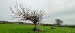

<< Our Photo Pages >> Lad of Crow Hill - Not Known (by us) in England in Yorkshire (West)
Submitted by Rombald on Thursday, 09 February 2006 Page Views: 11010
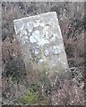
Date UncertainSite Name: Lad of Crow Hill Alternative Name: Scarr of Crow HillCountry: England County: Yorkshire (West) Type: Not Known (by us)
Nearest Town: Keighley Nearest Village: Stanbury
Map Ref: SD970370
Latitude: 53.829254N Longitude: 2.047062W
Condition:
| 5 | Perfect |
| 4 | Almost Perfect |
| 3 | Reasonable but with some damage |
| 2 | Ruined but still recognisable as an ancient site |
| 1 | Pretty much destroyed, possibly visible as crop marks |
| 0 | No data. |
| -1 | Completely destroyed |
| 5 | Superb |
| 4 | Good |
| 3 | Ordinary |
| 2 | Not Good |
| 1 | Awful |
| 0 | No data. |
| 5 | Can be driven to, probably with disabled access |
| 4 | Short walk on a footpath |
| 3 | Requiring a bit more of a walk |
| 2 | A long walk |
| 1 | In the middle of nowhere, a nightmare to find |
| 0 | No data. |
| 5 | co-ordinates taken by GPS or official recorded co-ordinates |
| 4 | co-ordinates scaled from a detailed map |
| 3 | co-ordinates scaled from a bad map |
| 2 | co-ordinates of the nearest village |
| 1 | co-ordinates of the nearest town |
| 0 | no data |
Internal Links:
External Links:
")
I have written a full article about this site in "Northern Earth" (issue 104, pp. 18-19).
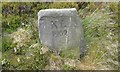
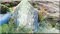
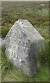
The Lad is a Yorkshire/Lancashire boundary stone, carved with the words "Lad or Scarr on Crow Hill", and probably dating from a boundary dispute in 1788. However, a "Skarth" at this site was recorded in the 15th century, and was probably a cairn. Furthermore, the boundary makes a kink at that point to meet it, suggesting that it pre-existed the boundary. Taking these points into consideration, I suggest that the stone was built on the site of a prehistoric burial cairn, and this could be the origin of the folktale about the Lad being the gravestone for a lad who died on the moors. The cairn might not finally have been removed until the 19th century.
You will really have to get Northern Earth to read the full article.
You may be viewing yesterday's version of this page. To see the most up to date information please register for a free account.
Do not use the above information on other web sites or publications without permission of the contributor.
Nearby Images from Geograph Britain and Ireland:
©2020(licence)
©2020(licence)

©2016(licence)
©2020(licence)
©2019(licence)
The above images may not be of the site on this page, they are loaded from Geograph.
Please Submit an Image of this site or go out and take one for us!
Click here to see more info for this site
Nearby sites
Key: Red: member's photo, Blue: 3rd party photo, Yellow: other image, Green: no photo - please go there and take one, Grey: site destroyed
Download sites to:
KML (Google Earth)
GPX (GPS waypoints)
CSV (Garmin/Navman)
CSV (Excel)
To unlock full downloads you need to sign up as a Contributory Member. Otherwise downloads are limited to 50 sites.
Turn off the page maps and other distractions
Nearby sites listing. In the following links * = Image available
1.1km ESE 118° Ponden Kirk* Rock Outcrop (SD9796936483)
1.2km SE 132° Robin Hood Well* Holy Well or Sacred Spring (SD979362)
1.2km ENE 65° Silver Hill* Round Barrow(s) (SD981375)
1.3km N 5° Watersheddles Cross* Standing Stone (Menhir) (SD9712338276)
1.3km SSE 166° Alcomden Stones* Rock Outcrop (SD9731335737)
1.4km N 356° Great Moss (Emmott Moor) Standing Stone (Menhir) (SD969384)
2.1km NNE 23° Old Bess Stone (Oakworth Moor) Standing Stone (Menhir) (SD978389)
2.1km NW 319° Coombe Hill (Wycoller) Ancient Cross (SD9558638608)
2.4km ESE 122° Cuckoo Stone (Yorkshire)* Standing Stones (SD99023573)
3.1km WNW 286° Brink Ends Cairn Cairn (SD94033786)
3.1km WSW 256° Boulsworth Hill Carvings* Carving (SD9397836237)
3.2km SSW 194° Shaw Dyke Hill* Standing Stones (SD96223388)
3.5km S 189° Walshaw Dean Reservoir* Stone Circle (SD96473355)
3.6km ESE 119° Wether Hill Brigstone Standing Stone (Menhir) (SE00203526)
3.7km N 358° Ickornshaw Moor* Rock Art (SD9689040731)
3.8km NW 309° Herder's Cross (Wycoller) Ancient Cross (SD9405639367)
3.9km ESE 119° Haworth Moor Spa (Haworth) Holy Well or Sacred Spring (SE00413513)
3.9km WNW 299° Wycoller Iron Age Bridge (Standing Stone)* Standing Stone (Menhir) (SD93583889)
4.0km NW 326° Emmott Moor Rock Art (SD9475040285)
4.1km S 191° Deerstones Rock Art (SD9624233015)
4.1km NW 312° Ratten Clough Cross (Emmot Moor) Ancient Cross (SD9399739746)
4.3km WSW 239° Dove Stones (Widdop Moor)* Natural Stone / Erratic / Other Natural Feature (SD93333479)
4.4km SSE 148° Thurrish Rough* Standing Stone (Menhir) (SD9933833320)
4.5km WNW 301° Wycoller Cup-marked Stones* Rock Art (SD931393)
4.5km ENE 76° Hare Hill (Oakworth) Standing Stone (Menhir) (SE014381)
View more nearby sites and additional images


 We would like to know more about this location. Please feel free to add a brief description and any relevant information in your own language.
 Wir möchten mehr über diese Stätte erfahren. Bitte zögern Sie nicht, eine kurze Beschreibung und relevante Informationen in Deutsch hinzuzufügen.
 Nous aimerions en savoir encore un peu sur les lieux. S'il vous plaît n'hesitez pas à ajouter une courte description et tous les renseignements pertinents dans votre propre langue.
 Quisieramos informarnos un poco más de las lugares. No dude en añadir una breve descripción y otros datos relevantes en su propio idioma.