

<< Our Photo Pages >> Anderlingen Steinkistengrab mit Bildstein - Cist in Germany in Lower Saxony, Bremen
Submitted by AlexHunger on Sunday, 09 October 2005 Page Views: 10157
Neolithic and Bronze AgeSite Name: Anderlingen Steinkistengrab mit Bildstein Alternative Name: Götterstein, DreigöttersteinCountry: Germany Land: Lower Saxony, Bremen Type: Cist
Nearest Town: Zeven Nearest Village: Anderlingen
Latitude: 53.378960N Longitude: 9.312764E
Condition:
| 5 | Perfect |
| 4 | Almost Perfect |
| 3 | Reasonable but with some damage |
| 2 | Ruined but still recognisable as an ancient site |
| 1 | Pretty much destroyed, possibly visible as crop marks |
| 0 | No data. |
| -1 | Completely destroyed |
| 5 | Superb |
| 4 | Good |
| 3 | Ordinary |
| 2 | Not Good |
| 1 | Awful |
| 0 | No data. |
| 5 | Can be driven to, probably with disabled access |
| 4 | Short walk on a footpath |
| 3 | Requiring a bit more of a walk |
| 2 | A long walk |
| 1 | In the middle of nowhere, a nightmare to find |
| 0 | No data. |
| 5 | co-ordinates taken by GPS or official recorded co-ordinates |
| 4 | co-ordinates scaled from a detailed map |
| 3 | co-ordinates scaled from a bad map |
| 2 | co-ordinates of the nearest village |
| 1 | co-ordinates of the nearest town |
| 0 | no data |
Internal Links:
External Links:
I have visited· I would like to visit
Andy B would like to visit
CharcoalBurner89 visited on 22nd Jan 2021 - their rating: Cond: 5 Amb: 4 Access: 4 One of the best reconstructions that can be found in northern Germany. Both the remains of the burial mound found in Anderlingen have been reconstructed (including the picture stone) and a complete tumulus.
Very easy to get to by car. It is right next to a street in the village of Anderlingen, with easy parking.
johnstone visited on 2nd Jul 2018 - their rating: Cond: 4 Amb: 4 Access: 5
Martin_L have visited here
Average ratings for this site from all visit loggers: Condition: 4.5 Ambience: 4 Access: 4.5
")
Text edited by holger_rix, April 2010
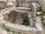
In September 1907 local farmer Gerdt Heinrich Brandt wanted
to salvage the material of one of the Round Barrows on his property,
when he suddenly found the remains of a stone cist.
He informed the local historic researcher Müller-Brauel, who
examined the cist and safed a few metal remains, including
a bronze axe. The cist had been disturbed before, for example
one of the three capstones had been moved to the side.
After that, the remains of the cist stayed there, and the autumn
rains washed the stones clean.
In January 1908 someone discovered carvings on one of the
supporting stones: The picture of three figures had become visible.
Now the Museum in Hannover was alarmed, and they send
Dr. Hans Hahne for a thorough examination.
Hahne found more stone settings, connected to the cist and
the barrows surrounding circle of stones.
The inner size of the chamber is 2m x 0.7m x 1m and it was
constructed appr. between 1700 and 1400 BCE.
Later the remains of the cist were moved to the museum in
Hannover, and rebuild outside in the park.
Anderlingen Steinkistengrab
The original carved stone of course is safed inside the museum.
Niedersächsisches Landesmuseum Hannover
After 100 years, the cist and a Round Barrow have been
reconstructed in the village of Anderlingen, the cist in the
original location. Luckily the reconstruction seem to have been well
planned and beautifully finished in 2008. This place is well worth
a visit, a unique experience.
Sources:
1.) Führer zu archäologischen Denkmälern in Deutschland, Band 4
Landkreis Rotenburg (Wümme) 1984
2.) http://www.anderlingen-brunkhorst.de/Ortsteile/Anderlingen/Anderlinger_Bildstein/anderlinger_bildstein.html
3.) http://www.urgeschichte.de/artikel/museum/museum12.htm
Original Text by AlexHunger:
The site was heavily damaged when farmers tried to salvage the material before the authorities put a stop to it. 1.13 metre tall menhir with carvings of 3 humanoids dated to early Bronze Age c. 1500 BCE and originally part of or close to Anderling Steingrab now located in the Niedersächsischen Landesmuseums Hannover, Willy-Brandt-Allee 5, 30169 Hannover.
Copy in Braunschweigisches Museum in Wolfenbüttel Archaeological Museum.
You may be viewing yesterday's version of this page. To see the most up to date information please register for a free account.
")
")
")
")
")
")
")
")
")
")
")
")
")
")
")
")
")
")
")
")
Do not use the above information on other web sites or publications without permission of the contributor.
Click here to see more info for this site
Nearby sites
Click here to view sites on an interactive map of the areaKey: Red: member's photo, Blue: 3rd party photo, Yellow: other image, Green: no photo - please go there and take one, Grey: site destroyed
Download sites to:
KML (Google Earth)
GPX (GPS waypoints)
CSV (Garmin/Navman)
CSV (Excel)
To unlock full downloads you need to sign up as a Contributory Member. Otherwise downloads are limited to 50 sites.
Turn off the page maps and other distractions
Nearby sites listing. In the following links * = Image available
1.7km SW 219° Rillenstein von Elsdorf* Sculptured Stone
1.7km SW 219° Steinzimmer Anderlingen* Museum
1.9km SW 223° Großsteingrab von Anderlingen* Chambered Tomb
2.2km W 272° Grabhügel bei Anderlingen* Round Barrow(s)
3.9km SW 218° Hügelgräber in Twistenbostel* Round Barrow(s)
4.2km N 1° Fehrenbruch Steinkistengrab* Cist
4.3km N 3° Fehrenbruch Grabhuegelgruppe* Barrow Cemetery
4.6km ENE 65° Kreisgrabenanlage bei Ahlerstedt-Oersdorf* Henge
4.8km SE 145° Hügelgräber am Fallohbach* Barrow Cemetery
5.0km SSE 160° Hügelgräber am Stimbeck* Barrow Cemetery
5.3km E 98° Grabhügel zwischen Wense und Ottendorf* Round Barrow(s)
5.4km SE 128° Brake Huegelgrab* Round Barrow(s)
5.5km E 101° Hexensteen bei Ottendorf* Marker Stone
5.5km ESE 102° Hünengraff bei Ottendorf* Modern Stone Circle etc
5.5km ESE 102° Gedenkstein Willi Wegewitz* Marker Stone
5.6km NW 320° Hügelgrab bei Malstedt* Round Barrow(s)
5.6km WNW 295° Grabhügel zwischen Deinstedt und Rohr* Round Barrow(s)
6.7km S 178° Grabhügel bei Heeslingen* Round Barrow(s)
6.7km W 267° Selsingen Schalenstein Milleniumwald* Rock Art
6.7km NNW 346° Byhusen Steingrab* Long Barrow
6.7km NNW 344° Byhusen Huegelgrab 2* Round Barrow(s)
6.7km N 349° Byhusen Huegelgrab 1* Round Barrow(s)
6.7km SSW 196° Grabhügel bei Brauel* Round Barrow(s)
6.8km NNW 343° Hügelgrab bei Byhusen (4)* Round Barrow(s)
6.8km NNW 346° Byhusen Huegelgrab 3* Round Barrow(s)
View more nearby sites and additional images


 We would like to know more about this location. Please feel free to add a brief description and any relevant information in your own language.
 Wir möchten mehr über diese Stätte erfahren. Bitte zögern Sie nicht, eine kurze Beschreibung und relevante Informationen in Deutsch hinzuzufügen.
 Nous aimerions en savoir encore un peu sur les lieux. S'il vous plaît n'hesitez pas à ajouter une courte description et tous les renseignements pertinents dans votre propre langue.
 Quisieramos informarnos un poco más de las lugares. No dude en añadir una breve descripción y otros datos relevantes en su propio idioma.