

St Mael and St Sulien
Submitted by TimPrevett on Saturday, 22 April 2006 Page Views: 10748
Neolithic and Bronze AgeSite Name: St Mael and St Sulien Alternative Name: Carreg y Big yn y Fach Rhewllyd; Corwen Parish ChurchCountry: Wales County: Denbighshire Type: Standing Stone (Menhir)
Nearest Town: Corwen
Map Ref: SJ0787243397
Latitude: 52.979971N Longitude: 3.373592W
Condition:
| 5 | Perfect |
| 4 | Almost Perfect |
| 3 | Reasonable but with some damage |
| 2 | Ruined but still recognisable as an ancient site |
| 1 | Pretty much destroyed, possibly visible as crop marks |
| 0 | No data. |
| -1 | Completely destroyed |
| 5 | Superb |
| 4 | Good |
| 3 | Ordinary |
| 2 | Not Good |
| 1 | Awful |
| 0 | No data. |
| 5 | Can be driven to, probably with disabled access |
| 4 | Short walk on a footpath |
| 3 | Requiring a bit more of a walk |
| 2 | A long walk |
| 1 | In the middle of nowhere, a nightmare to find |
| 0 | No data. |
| 5 | co-ordinates taken by GPS or official recorded co-ordinates |
| 4 | co-ordinates scaled from a detailed map |
| 3 | co-ordinates scaled from a bad map |
| 2 | co-ordinates of the nearest village |
| 1 | co-ordinates of the nearest town |
| 0 | no data |
8 photos by 3 photographers
Internal Links:


External Links:


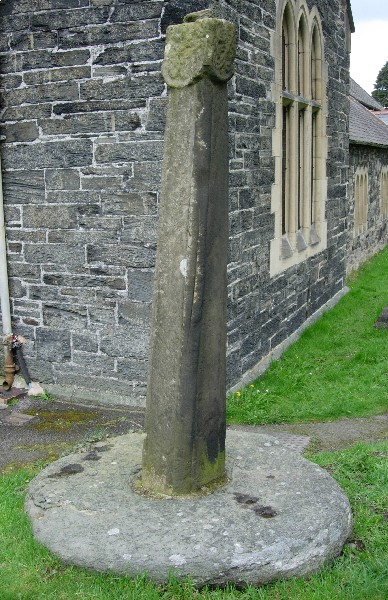
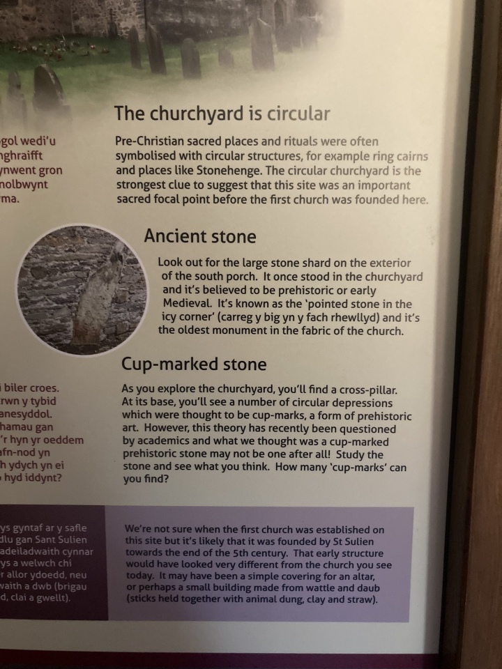
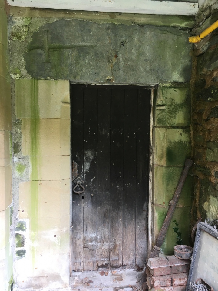
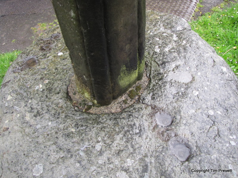
A most definite example of the Christianisation of an existing prehistorc site. At the church of St Mael and St Sulien in Corwen can be found a few features of interest. First is a standing stone built into the east side of the porch, the second is an allegedly cup marked stone forming the base of a 12th Century cross shaft to the south west side of the church building. The leaflet for Corwen Town Trail (Exploring Corwen produced by Denbighshire County Council Tourism Dept 2004) notes the stone as possibly 9th Century.
Nearest parking is on the north side of the A5 a few minutes away off Green Lane. The church can be accessed by crossing the road a little to the west of the Owain Glyndwr monument. The church is high off the south side of the A5.
Update June 2017: Coflein List Entry 306609, which adds: "The cross consists of a 2.2m high square sectioned, tapering cross-shaft, with an ornamented head and an inscribed cross on its east face. This is set in a circular base-stone, 1.6m in diameter and 0.3m high. A late eighteenth century drawing shows what appears to be a possible decayed wheel-head cross. A runic inscription has been claimed."
The cross and its base are also featured on The Northern Antiquarian (TNA) page for Corwen Cross, Denbighshire, which adds: "two other crosses are found at Corwen church, one of which has a decidedly heathen legend attached to it." The Journal of Antiquities also includes an entry for the Church of St Mael and St Sulien, Corwen, Denbighshire, Wales, which includes a photograph of the cross in the churchyard, tells us the church also houses a small collection of antiquities that are well worth viewing, and describes a "strange shaped stone in the porch wall that could pre-date the church and above the priest's door a flat stone bearing an incised cross".
You may be viewing yesterday's version of this page. To see the most up to date information please register for a free account.


Do not use the above information on other web sites or publications without permission of the contributor.
Click here to see more info for this site
Log in or create a free account to see nearby ancient sites our visitors rate highly
All Nearby sites
 Click here to view sites on an interactive OS map
Download sites to:
KML (Google Earth)
GPX (GPS waypoints)
CSV (Garmin/Navman)
CSV (Excel)
To unlock full downloads you need to sign up as a Society Member. Otherwise downloads are limited to 50 sites.
Turn off the page maps and other distractions
Nearby sites listing. In the following links * = Image available
297m SW 232° Corwen Gorsedd Circle Modern Stone Circle etc (SJ0763443219)
1.2km NW 304° Ffynnon Sulien* Holy Well or Sacred Spring (SJ06884409)
1.3km NE 41° Caer Drewyn* Hillfort (SJ0876544395)
1.6km NE 50° Pen Coed Mawr field system* Ancient Village or Settlement (SJ09124441)
1.6km W 273° Llyn-y-cefn Cursus Cursus (SJ06254350)
1.7km W 270° Corwen Cursus Cursus (SJ06204343)
1.7km W 267° Corwen Cursus Cursus (SJ06194335)
2.0km W 273° Llyn-y-cefn Cursus Cursus (SJ05854355)
2.8km WSW 242° Gwerclas Burial Mound* Long Barrow (SJ0539042130)
3.5km N 354° Ffynnon Beuno (Gwyddelwern)* Holy Well or Sacred Spring (SJ07584692)
4.3km NE 36° Bwrdd y Tri Arglwydd* Chambered Tomb (SJ10454682)
4.4km ESE 105° Carrog Uchaf Round Barrows* Round Barrow(s) (SJ1210042150)
4.7km SSE 155° Nant Croes Y Wernen* Stone Circle (SJ09813906)
4.9km E 93° Owain Glyndwr's House (Site of)* Rock Art (SJ12754309)
4.9km SW 218° Tyn y Coed* Chambered Cairn (SJ0476839603)
5.2km SE 132° Moel Fferna, Y Berwyn* Round Cairn (SJ1168039790)
5.7km ESE 112° Plasnewydd Round Cairns* Round Cairn (SJ1316641192)
5.8km SE 130° Moel Fferna Standing Stone* Standing Stones (SJ1223339572)
6.1km ESE 107° Cwm Ganol Cairn* Round Cairn (SJ13674151)
6.1km ESE 107° Cwm Ganol Standing Stone* Standing Stone (Menhir) (SJ13674151)
6.5km NNW 332° Dinas Melin-y-Wig* Hillfort (SJ049492)
6.6km SSW 199° Moel Ty Uchaf* Stone Circle (SJ0561037170)
6.6km NNE 31° Tom Dongen Round Barrow* Round Barrow(s) (SJ1137049060)
6.7km S 173° Pen Bwlch Llandrillo Cairn (SJ08513674)
6.8km SW 226° Tyfos* Stone Circle (SJ02843876)
View more nearby sites and additional images

 We would like to know more about this location. Please feel free to add a brief description and any relevant information in your own language.
 Wir möchten mehr über diese Stätte erfahren. Bitte zögern Sie nicht, eine kurze Beschreibung und relevante Informationen in Deutsch hinzuzufügen.
 Nous aimerions en savoir encore un peu sur les lieux. S'il vous plaît n'hesitez pas à ajouter une courte description et tous les renseignements pertinents dans votre propre langue.
 Quisieramos informarnos un poco más de las lugares. No dude en añadir una breve descripción y otros datos relevantes en su propio idioma.