


<< Other Photo Pages >> Wat Kamphaeng Laeng - Ancient Temple in Thailand
Submitted by KaiHofmann on Thursday, 02 March 2017 Page Views: 1182
Multi-periodSite Name: Wat Kamphaeng LaengCountry: Thailand
NOTE: This site is 61.245 km away from the location you searched for.
Type: Ancient Temple
Nearest Town: Phetchaburi
Latitude: 13.105407N Longitude: 99.955865E
Condition:
| 5 | Perfect |
| 4 | Almost Perfect |
| 3 | Reasonable but with some damage |
| 2 | Ruined but still recognisable as an ancient site |
| 1 | Pretty much destroyed, possibly visible as crop marks |
| 0 | No data. |
| -1 | Completely destroyed |
| 5 | Superb |
| 4 | Good |
| 3 | Ordinary |
| 2 | Not Good |
| 1 | Awful |
| 0 | No data. |
| 5 | Can be driven to, probably with disabled access |
| 4 | Short walk on a footpath |
| 3 | Requiring a bit more of a walk |
| 2 | A long walk |
| 1 | In the middle of nowhere, a nightmare to find |
| 0 | No data. |
| 5 | co-ordinates taken by GPS or official recorded co-ordinates |
| 4 | co-ordinates scaled from a detailed map |
| 3 | co-ordinates scaled from a bad map |
| 2 | co-ordinates of the nearest village |
| 1 | co-ordinates of the nearest town |
| 0 | no data |
Internal Links:
External Links:
")
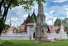
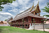
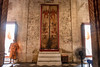
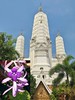
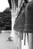
The Wat Kamphaeng Laeng monastery was built in Khmer style in the 12th century CE. Today the ruins could be visited.
You may be viewing yesterday's version of this page. To see the most up to date information please register for a free account.
Do not use the above information on other web sites or publications without permission of the contributor.
Nearby Images from Flickr

The above images may not be of the site on this page, but were taken nearby. They are loaded from Flickr so please click on them for image credits.
Click here to see more info for this site
Nearby sites
Click here to view sites on an interactive map of the areaKey: Red: member's photo, Blue: 3rd party photo, Yellow: other image, Green: no photo - please go there and take one, Grey: site destroyed
Download sites to:
KML (Google Earth)
GPX (GPS waypoints)
CSV (Garmin/Navman)
CSV (Excel)
To unlock full downloads you need to sign up as a Contributory Member. Otherwise downloads are limited to 50 sites.
Turn off the page maps and other distractions
Nearby sites listing. In the following links * = Image available
80.2km N 8° Phra Pathommachedi* Ancient Temple
80.4km N 11° Phra Prathon Chedi* Ancient Temple
92.9km NE 39° Bangkok National Museum* Museum
139.2km ENE 68° Khok Phanom Di* Ancient Village or Settlement
153.5km NNE 25° Ayutthaya Historical Park* Ancient Village or Settlement
201.9km NNE 21° Lopburi Temples* Ancient Temple
345.4km E 92° Wat Banan Ancient Temple
346.9km NE 46° Ban Non Wat Ancient Village or Settlement
350.0km E 89° Wat Ek Phnom* Ancient Temple
356.5km ENE 72° Banteay Chhmar Ancient Temple
369.5km ESE 104° Cardamom Mountains rock paintings Rock Art
406.4km S 179° Grandma and Grandpa Rocks* Natural Stone / Erratic / Other Natural Feature
413.0km E 85° Prasat Prei Kmeng Ancient Temple
415.1km E 85° Ak Yum Ancient Temple
416.6km E 85° Prasat Kas Ho Ancient Temple
417.7km E 85° West Mebon Ancient Temple
418.0km E 87° Phnom Krom* Ancient Temple
418.5km E 85° Prasat Ta Noreay Ancient Temple
421.2km E 86° Wat Athvea* Ancient Temple
422.2km SSW 192° Wat Phra Borommathtat Ancient Temple
422.3km E 84° Prasat Prei Ancient Temple
422.3km SSW 191° Wat Long Ancient Temple
422.5km E 84° Angkor Thom West Gate* Ancient Temple
422.8km E 84° Prasat Banteay Thom* Ancient Temple
422.8km SSW 191° Chedi Wat Kaew Ancient Temple
View more nearby sites and additional images


 We would like to know more about this location. Please feel free to add a brief description and any relevant information in your own language.
 Wir möchten mehr über diese Stätte erfahren. Bitte zögern Sie nicht, eine kurze Beschreibung und relevante Informationen in Deutsch hinzuzufügen.
 Nous aimerions en savoir encore un peu sur les lieux. S'il vous plaît n'hesitez pas à ajouter une courte description et tous les renseignements pertinents dans votre propre langue.
 Quisieramos informarnos un poco más de las lugares. No dude en añadir una breve descripción y otros datos relevantes en su propio idioma.