

<< Text Pages >> Siedlung Forschner - Ancient Village or Settlement in Germany in Baden-Wuerttemberg
Submitted by Harald_Platta on Saturday, 23 November 2019 Page Views: 520
Neolithic and Bronze AgeSite Name: Siedlung ForschnerCountry: Germany
NOTE: This site is 1.968 km away from the location you searched for.
Land: Baden-Wuerttemberg Type: Ancient Village or Settlement
Nearest Town: Bad Buchau
Latitude: 48.054861N Longitude: 9.640528E
Condition:
| 5 | Perfect |
| 4 | Almost Perfect |
| 3 | Reasonable but with some damage |
| 2 | Ruined but still recognisable as an ancient site |
| 1 | Pretty much destroyed, possibly visible as crop marks |
| 0 | No data. |
| -1 | Completely destroyed |
| 5 | Superb |
| 4 | Good |
| 3 | Ordinary |
| 2 | Not Good |
| 1 | Awful |
| 0 | No data. |
| 5 | Can be driven to, probably with disabled access |
| 4 | Short walk on a footpath |
| 3 | Requiring a bit more of a walk |
| 2 | A long walk |
| 1 | In the middle of nowhere, a nightmare to find |
| 0 | No data. |
| 5 | co-ordinates taken by GPS or official recorded co-ordinates |
| 4 | co-ordinates scaled from a detailed map |
| 3 | co-ordinates scaled from a bad map |
| 2 | co-ordinates of the nearest village |
| 1 | co-ordinates of the nearest town |
| 0 | no data |
Internal Links:
External Links:
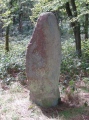
The prehistoric pile dwelling Siedlung Forschner is located in Bad Buchau (Baden-Wuerttemberg, Germany) in the Federsee Lake area. It was used in the Bronze Age most likely by the Hügelgräber-Kultur (1767–1480 BC).
Today, the original remains of the settlement are preserved beneath the ground.
The site is part of the UNESCO world heritage Prehistoric pile dwellings around the Alps.
Reference:
unesco-pfahlbauten-org: Siedlung Forschner: Welterbestätte DE-BW-15.
You may be viewing yesterday's version of this page. To see the most up to date information please register for a free account.
Do not use the above information on other web sites or publications without permission of the contributor.
Nearby Images from Flickr

The above images may not be of the site on this page, but were taken nearby. They are loaded from Flickr so please click on them for image credits.
Click here to see more info for this site
Nearby sites
Click here to view sites on an interactive map of the areaKey: Red: member's photo, Blue: 3rd party photo, Yellow: other image, Green: no photo - please go there and take one, Grey: site destroyed
Download sites to:
KML (Google Earth)
GPX (GPS waypoints)
CSV (Garmin/Navman)
CSV (Excel)
To unlock full downloads you need to sign up as a Contributory Member. Otherwise downloads are limited to 50 sites.
Turn off the page maps and other distractions
Nearby sites listing. In the following links * = Image available
2.8km NW 307° Bad Buchau Museum* Museum
2.8km NW 316° Federseeried Prähistorische Siedlungslandschaft Ancient Village or Settlement
6.1km N 350° Grundwiesen Ancient Village or Settlement
6.3km ENE 72° Mittelbiberach Keltische Viereckschanze Ancient Village or Settlement
7.2km N 0° Ödenahlen Ancient Village or Settlement
7.2km SSE 150° Olzreute-Enzisholz Ancient Village or Settlement
8.2km WSW 240° Schelmberg Wald Keltische Viereckschanze Ancient Village or Settlement
13.5km WNW 295° Rauer Lehen Grabhügel Artificial Mound
13.7km NNW 332° Bussen Vorgeschichtliche Höhensiedlung Hillfort
14.2km N 5° Grundsheim Grabhügelgruppe Barrow Cemetery
16.0km W 278° Bettelbühl Round Barrow(s)
17.6km WNW 285° Heunenburg* Hillfort
17.6km WNW 282° Baumburg Artificial Mound
17.6km W 279° Lehenbühl Grabhügel Artificial Mound
18.1km W 279° Heunenburg Museum Museum
18.2km WNW 286° Giessübel-Talhau Grabhügelgruppe* Artificial Mound
19.1km NNW 341° Langhau Wald Keltische Viereckschanze Ancient Village or Settlement
19.3km SSW 196° Schreckensee Ancient Village or Settlement
19.3km NNW 341° Langhau Wald Grabhügelgruppe Barrow Cemetery
19.4km WNW 294° Ruchenholz Wald Keltische Viereckschanze 1 Ancient Village or Settlement
19.6km WNW 283° Hohmichele Grabhügel* Artificial Mound
20.8km S 175° Hartwald Grabhügelgruppe Barrow Cemetery
20.9km WNW 296° Ruchenholz Wald Keltische Viereckschanze 2 Ancient Village or Settlement
21.1km S 175° Baindt Viereckschanze Ancient Village or Settlement
22.3km W 273° Mengen-Ennetach Grabhügel Artificial Mound
View more nearby sites and additional images


 We would like to know more about this location. Please feel free to add a brief description and any relevant information in your own language.
 Wir möchten mehr über diese Stätte erfahren. Bitte zögern Sie nicht, eine kurze Beschreibung und relevante Informationen in Deutsch hinzuzufügen.
 Nous aimerions en savoir encore un peu sur les lieux. S'il vous plaît n'hesitez pas à ajouter une courte description et tous les renseignements pertinents dans votre propre langue.
 Quisieramos informarnos un poco más de las lugares. No dude en añadir una breve descripción y otros datos relevantes en su propio idioma.