<< Text Pages >> Lakhudiyar Rock Art - Rock Art in India
Submitted by Andy B on Thursday, 06 December 2018 Page Views: 2147
Rock ArtSite Name: Lakhudiyar Rock ArtCountry: India
NOTE: This site is 153.694 km away from the location you searched for.
Type: Rock Art
Nearest Village: Barechhina
Latitude: 29.629120N Longitude: 79.713439E
Condition:
| 5 | Perfect |
| 4 | Almost Perfect |
| 3 | Reasonable but with some damage |
| 2 | Ruined but still recognisable as an ancient site |
| 1 | Pretty much destroyed, possibly visible as crop marks |
| 0 | No data. |
| -1 | Completely destroyed |
| 5 | Superb |
| 4 | Good |
| 3 | Ordinary |
| 2 | Not Good |
| 1 | Awful |
| 0 | No data. |
| 5 | Can be driven to, probably with disabled access |
| 4 | Short walk on a footpath |
| 3 | Requiring a bit more of a walk |
| 2 | A long walk |
| 1 | In the middle of nowhere, a nightmare to find |
| 0 | No data. |
| 5 | co-ordinates taken by GPS or official recorded co-ordinates |
| 4 | co-ordinates scaled from a detailed map |
| 3 | co-ordinates scaled from a bad map |
| 2 | co-ordinates of the nearest village |
| 1 | co-ordinates of the nearest town |
| 0 | no data |
Internal Links:
External Links:
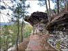
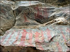
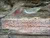
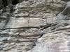
Two prehistoric painted rock shelters, at Lakhudiyar, which literally means 'one lakh caves', on the banks of the Suyal river. There are paintings of animals, humans and also tectiforms done with fingers in black, red and white colours, and engravings of trishul and Swastika.
These images have become a tourist attraction, and studied by Indira Gandhi National Centre for the Arts, New Delhi.
You may be viewing yesterday's version of this page. To see the most up to date information please register for a free account.
Do not use the above information on other web sites or publications without permission of the contributor.
Nearby Images from Flickr

The above images may not be of the site on this page, but were taken nearby. They are loaded from Flickr so please click on them for image credits.
Click here to see more info for this site
Nearby sites
Click here to view sites on an interactive map of the areaKey: Red: member's photo, Blue: 3rd party photo, Yellow: other image, Green: no photo - please go there and take one, Grey: site destroyed
Download sites to:
KML (Google Earth)
GPX (GPS waypoints)
CSV (Garmin/Navman)
CSV (Excel)
To unlock full downloads you need to sign up as a Contributory Member. Otherwise downloads are limited to 50 sites.
Turn off the page maps and other distractions
Nearby sites listing. In the following links * = Image available
274.7km WSW 244° Qutab Minar Complex* Ancient Temple
278.4km NW 319° Shri Bhima Kali Temple at Sarahan* Ancient Temple
290.4km WSW 256° Farmana Harappan burial site Ancient Village or Settlement
350.6km W 265° Rakhigarhi* Ancient Village or Settlement
361.7km S 169° Jajmau ka tila Ancient Village or Settlement
368.1km NW 319° Gauri Shankar* Ancient Temple
379.2km NW 321° Manu Maharishi Temple* Ancient Temple
379.6km NW 321° Vashisht Temple Bowls* Ancient Temple
422.4km ESE 109° Syauli stone* Natural Stone / Erratic / Other Natural Feature
469.0km NNW 337° TaglangLa Pass Buddhist road temple* Ancient Temple
480.4km SE 131° Bansdeela-Teelatar Ancient Village or Settlement
516.7km NNW 336° Markha valley Ladakh, Shorten's (Stupa's)* Ancient Temple
526.4km NNW 339° Nyerma Monastery* Ancient Temple
528.8km NNW 339° Thiksey (Kthiksey) Buddhist monestry in Ladak* Ancient Temple
532.1km NNW 339° Shey buddha engravings* Carving
535.1km NNW 339° Ladak N' India* Ancient Temple
537.2km NNW 339° Saboo Rock* Rock Art
543.8km NNW 339° Maitreya Buddha and Avalokiteshvara rock carving* Sculptured Stone
550.3km NNW 337° Taroo petroglyphs Rock Art
562.5km NNW 336° Chilungtse altar stone Carving
564.2km NNW 336° Alchi Gompa* Ancient Temple
566.5km NNW 341° Kardung petroglyphs* Rock Art
566.8km NNW 335° Alchi petroglyphs* Rock Art
573.9km ESE 109° Pang-2 Cave or Rock Shelter
577.3km NNW 335° Hemis Shukpachan Menhir* Standing Stone (Menhir)
View more nearby sites and additional images


 We would like to know more about this location. Please feel free to add a brief description and any relevant information in your own language.
 Wir möchten mehr über diese Stätte erfahren. Bitte zögern Sie nicht, eine kurze Beschreibung und relevante Informationen in Deutsch hinzuzufügen.
 Nous aimerions en savoir encore un peu sur les lieux. S'il vous plaît n'hesitez pas à ajouter une courte description et tous les renseignements pertinents dans votre propre langue.
 Quisieramos informarnos un poco más de las lugares. No dude en añadir una breve descripción y otros datos relevantes en su propio idioma.