
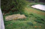

<< Our Photo Pages >> Cuccuru e Lai - Sculptured Stone in Italy in Sardinia (Sardegna)
Submitted by davidmorgan on Wednesday, 21 September 2011 Page Views: 4336
Multi-periodSite Name: Cuccuru e LaiCountry: Italy
NOTE: This site is 0.289 km away from the location you searched for.
Region: Sardinia (Sardegna) Type: Sculptured Stone
Nearest Town: Samugheo
Latitude: 39.949600N Longitude: 8.939900E
Condition:
| 5 | Perfect |
| 4 | Almost Perfect |
| 3 | Reasonable but with some damage |
| 2 | Ruined but still recognisable as an ancient site |
| 1 | Pretty much destroyed, possibly visible as crop marks |
| 0 | No data. |
| -1 | Completely destroyed |
| 5 | Superb |
| 4 | Good |
| 3 | Ordinary |
| 2 | Not Good |
| 1 | Awful |
| 0 | No data. |
| 5 | Can be driven to, probably with disabled access |
| 4 | Short walk on a footpath |
| 3 | Requiring a bit more of a walk |
| 2 | A long walk |
| 1 | In the middle of nowhere, a nightmare to find |
| 0 | No data. |
| 5 | co-ordinates taken by GPS or official recorded co-ordinates |
| 4 | co-ordinates scaled from a detailed map |
| 3 | co-ordinates scaled from a bad map |
| 2 | co-ordinates of the nearest village |
| 1 | co-ordinates of the nearest town |
| 0 | no data |
Internal Links:
External Links:
I have visited· I would like to visit
Andy B has visited here
")
A drystone wall entirely made of broken stelae-statues, many carved with stylised human figures, could make the site at Cuccuru e Lai, near Samugheo, one of the most important prehistoric sanctuaries of the island.
Note: Dozens of statue menhirs found in a Sardinian wall
You may be viewing yesterday's version of this page. To see the most up to date information please register for a free account.
Do not use the above information on other web sites or publications without permission of the contributor.
Nearby Images from Flickr


The above images may not be of the site on this page, but were taken nearby. They are loaded from Flickr so please click on them for image credits.
Click here to see more info for this site
Nearby sites
Click here to view sites on an interactive map of the areaKey: Red: member's photo, Blue: 3rd party photo, Yellow: other image, Green: no photo - please go there and take one, Grey: site destroyed
Download sites to:
KML (Google Earth)
GPX (GPS waypoints)
CSV (Garmin/Navman)
CSV (Excel)
To unlock full downloads you need to sign up as a Contributory Member. Otherwise downloads are limited to 50 sites.
Turn off the page maps and other distractions
Nearby sites listing. In the following links * = Image available
3.7km WNW 289° Sa Mura Nuraghe (Samugheo) Broch or Nuraghe
5.5km SW 224° Mesadda Domus de Janas* Rock Cut Tomb
6.3km WNW 292° Arasseda Nuraghe Broch or Nuraghe
6.6km E 80° Abbagadda Nuraghe* Broch or Nuraghe
6.8km ENE 61° Accoro Nuedda Nuraghe* Broch or Nuraghe
7.7km SE 137° Orrubiu Nuraghe Broch or Nuraghe
8.3km SE 130° Genna Corte Nuraghe* Broch or Nuraghe
8.6km SSW 193° Brentoni* Stone Row / Alignment
8.7km SE 134° Masone Perdu* Chambered Tomb
8.8km SSW 208° Baduggiana Standing Stone (Menhir)
8.8km NNE 16° Pira 'e Zuri Nuraghe Broch or Nuraghe
8.8km SSW 201° Is Forrus Domus de Janas* Rock Cut Tomb
8.9km SSW 202° Curru Tundu* Standing Stones
9.1km SSW 194° Cara Bassa* Stone Row / Alignment
9.1km SE 134° Corte Noa Menhir I* Standing Stone (Menhir)
9.2km SSW 206° Tuttiricchiu* Standing Stone (Menhir)
9.2km SE 130° Picciu Nuraghe* Broch or Nuraghe
9.2km NNW 333° Marapela Nuraghe Broch or Nuraghe
9.2km NNE 22° Su Linnari Nuraghe Broch or Nuraghe
9.3km SE 134° Corte Noa Stone row* Stone Row / Alignment
9.4km NNW 330° Sa Giacca Protonuraghe Broch or Nuraghe
9.4km SE 133° Corte Noa Dolmen* Burial Chamber or Dolmen
9.5km SE 136° Perda Iddocca* Standing Stones
9.7km SSW 213° Friarosu Protonuraghe* Broch or Nuraghe
10.0km S 173° Asuni Menhir* Standing Stones
View more nearby sites and additional images


 We would like to know more about this location. Please feel free to add a brief description and any relevant information in your own language.
 Wir möchten mehr über diese Stätte erfahren. Bitte zögern Sie nicht, eine kurze Beschreibung und relevante Informationen in Deutsch hinzuzufügen.
 Nous aimerions en savoir encore un peu sur les lieux. S'il vous plaît n'hesitez pas à ajouter une courte description et tous les renseignements pertinents dans votre propre langue.
 Quisieramos informarnos un poco más de las lugares. No dude en añadir una breve descripción y otros datos relevantes en su propio idioma.