<< Our Photo Pages >> Abri Schweizersbild - Cave or Rock Shelter in Switzerland in Schaffhausen
Submitted by KaiHofmann on Monday, 30 May 2011 Page Views: 5666
Neolithic and Bronze AgeSite Name: Abri SchweizersbildCountry: Switzerland
NOTE: This site is 5.549 km away from the location you searched for.
Canton: Schaffhausen Type: Cave or Rock Shelter
Nearest Town: Schaffhausen Nearest Village: Schaffhausen
Latitude: 47.723880N Longitude: 8.640070E
Condition:
| 5 | Perfect |
| 4 | Almost Perfect |
| 3 | Reasonable but with some damage |
| 2 | Ruined but still recognisable as an ancient site |
| 1 | Pretty much destroyed, possibly visible as crop marks |
| 0 | No data. |
| -1 | Completely destroyed |
| 5 | Superb |
| 4 | Good |
| 3 | Ordinary |
| 2 | Not Good |
| 1 | Awful |
| 0 | No data. |
| 5 | Can be driven to, probably with disabled access |
| 4 | Short walk on a footpath |
| 3 | Requiring a bit more of a walk |
| 2 | A long walk |
| 1 | In the middle of nowhere, a nightmare to find |
| 0 | No data. |
| 5 | co-ordinates taken by GPS or official recorded co-ordinates |
| 4 | co-ordinates scaled from a detailed map |
| 3 | co-ordinates scaled from a bad map |
| 2 | co-ordinates of the nearest village |
| 1 | co-ordinates of the nearest town |
| 0 | no data |
Be the first person to rate this site - see the 'Contribute!' box in the right hand menu.
Internal Links:
External Links:
I have visited· I would like to visit
nosnava visited on 1st May 2022 - their rating: Cond: 4 Amb: 4 Access: 4
")
In Abri cave many Palaeolithic artefacts and Neolithic burials has been found. One of the artefacts is a plate with engravings of 2 horses.
The site is located in Kanton Schaffhausen.
You may be viewing yesterday's version of this page. To see the most up to date information please register for a free account.
")
Do not use the above information on other web sites or publications without permission of the contributor.
Nearby Images from Flickr
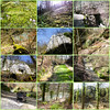


The above images may not be of the site on this page, but were taken nearby. They are loaded from Flickr so please click on them for image credits.
Click here to see more info for this site
Nearby sites
Click here to view sites on an interactive map of the areaKey: Red: member's photo, Blue: 3rd party photo, Yellow: other image, Green: no photo - please go there and take one, Grey: site destroyed
Download sites to:
KML (Google Earth)
GPX (GPS waypoints)
CSV (Garmin/Navman)
CSV (Excel)
To unlock full downloads you need to sign up as a Contributory Member. Otherwise downloads are limited to 50 sites.
Turn off the page maps and other distractions
Nearby sites listing. In the following links * = Image available
4.7km ENE 59° Kesslerloch* Cave or Rock Shelter
8.0km SSW 192° Altenburg Keltisches Oppidum Museum
11.9km NNW 345° Blauer Stein Natural Stone / Erratic / Other Natural Feature
12.9km NE 39° Ertenhag Grabhügelgruppe Barrow Cemetery
19.1km WSW 250° Degernau Menhir* Standing Stone (Menhir)
19.5km WSW 251° Steinkiste Degernau* Chambered Tomb
19.7km NE 39° Petersfels* Rock Outcrop
21.5km NE 38° Ziegelhau Grabhügelgruppe Barrow Cemetery
22.7km ESE 108° Museum Fischerhaus Öhningen-Wangen* Museum
23.4km ESE 107° Wangen-Hinterhorn* Crannog
24.5km WNW 295° Summstein Bonndorf Modern Stone Circle etc
26.5km NNW 346° Buckhäule Grabhügelgruppe Barrow Cemetery
27.6km E 97° Hornstaad-Hörnle Pfahlbausiedlungen Crannog
27.7km NNW 344° Unterer Schiessbühl Grabhügelgruppe Barrow Cemetery
27.8km NW 320° Guldenen Grabhügelgruppe Barrow Cemetery
28.0km NNW 343° Oberer Schiessbühl Grabhügelgruppe Barrow Cemetery
28.8km ENE 64° Bogental Grabhügelgruppe Barrow Cemetery
29.2km WSW 249° Langenstein - Tiengen* Standing Stone (Menhir)
29.4km NE 38° Henneleh Grabhügelgruppe Barrow Cemetery
30.3km E 85° Heidenbühl Grabhügel Artificial Mound
31.5km ENE 71° Bodman-Schachen/Löchle Crannog
31.9km ENE 60° Heidenhöhlen Stockach Cave or Rock Shelter
32.3km W 262° Langstein - Weilheim* Standing Stone (Menhir)
32.9km E 80° Hals Höhensiedlung Hillfort
32.9km E 93° Allensbach-Strandbad* Crannog
View more nearby sites and additional images


 We would like to know more about this location. Please feel free to add a brief description and any relevant information in your own language.
 Wir möchten mehr über diese Stätte erfahren. Bitte zögern Sie nicht, eine kurze Beschreibung und relevante Informationen in Deutsch hinzuzufügen.
 Nous aimerions en savoir encore un peu sur les lieux. S'il vous plaît n'hesitez pas à ajouter une courte description et tous les renseignements pertinents dans votre propre langue.
 Quisieramos informarnos un poco más de las lugares. No dude en añadir una breve descripción y otros datos relevantes en su propio idioma.