

<< Our Photo Pages >> Horster Sonnenstein - Rock Art in Germany in Lower Saxony, Bremen
Submitted by peterpf on Sunday, 30 July 2006 Page Views: 6017
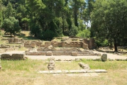
Rock ArtSite Name: Horster Sonnenstein Alternative Name: Horsten SonnensteinCountry: Germany
NOTE: This site is 7.575 km away from the location you searched for.
Land: Lower Saxony, Bremen Type: Rock Art
Nearest Town: Horsten
Latitude: 53.450770N Longitude: 7.938880E
Condition:
| 5 | Perfect |
| 4 | Almost Perfect |
| 3 | Reasonable but with some damage |
| 2 | Ruined but still recognisable as an ancient site |
| 1 | Pretty much destroyed, possibly visible as crop marks |
| 0 | No data. |
| -1 | Completely destroyed |
| 5 | Superb |
| 4 | Good |
| 3 | Ordinary |
| 2 | Not Good |
| 1 | Awful |
| 0 | No data. |
| 5 | Can be driven to, probably with disabled access |
| 4 | Short walk on a footpath |
| 3 | Requiring a bit more of a walk |
| 2 | A long walk |
| 1 | In the middle of nowhere, a nightmare to find |
| 0 | No data. |
| 5 | co-ordinates taken by GPS or official recorded co-ordinates |
| 4 | co-ordinates scaled from a detailed map |
| 3 | co-ordinates scaled from a bad map |
| 2 | co-ordinates of the nearest village |
| 1 | co-ordinates of the nearest town |
| 0 | no data |
Internal Links:
External Links:
I have visited· I would like to visit
CharcoalBurner89 visited on 20th Aug 2022 - their rating: Cond: 4 Amb: 2 Access: 5 Incredibly good replica. The original is in Horsten's local school!
")
This "Sun-Stone" carries 17 encarved circles as sun symbols.
You may be viewing yesterday's version of this page. To see the most up to date information please register for a free account.
")
")
")
")
")
Do not use the above information on other web sites or publications without permission of the contributor.
Click here to see more info for this site
Nearby sites
Click here to view sites on an interactive map of the areaKey: Red: member's photo, Blue: 3rd party photo, Yellow: other image, Green: no photo - please go there and take one, Grey: site destroyed
Download sites to:
KML (Google Earth)
GPX (GPS waypoints)
CSV (Garmin/Navman)
CSV (Excel)
To unlock full downloads you need to sign up as a Contributory Member. Otherwise downloads are limited to 50 sites.
Turn off the page maps and other distractions
Nearby sites listing. In the following links * = Image available
4.5km W 275° Stapelstein* Cist
9.3km WSW 238° Der Hunt* Standing Stones
10.3km WNW 293° Oll Gries* Marker Stone
10.5km NW 305° Hügelgräber Rispel* Barrow Cemetery
14.0km WSW 255° Wiesmoor Monolith* Standing Stone (Menhir)
14.2km SW 217° Monolith Ockenhausen Standing Stone (Menhir)
15.4km ESE 109° Haselberg* Round Barrow(s)
19.0km WNW 301° Hilgensteen* Natural Stone / Erratic / Other Natural Feature
22.5km NW 317° Foskort* Rock Art
24.8km NW 308° Radbodsberg* Round Barrow(s)
26.7km NW 317° Rillenstein von Stedesdorf* Sculptured Stone
31.8km WNW 283° Grosssteingrab Aurich-Tannenhausen* Chambered Tomb
32.1km E 99° Bronzezeithaus in Hartwarderwurp* Ancient Village or Settlement
35.2km SE 142° Wahnbek Alte Kapelle* Passage Grave
35.2km ESE 119° Steinsetzungen Oldenbrok* Modern Stone Circle etc
41.5km SW 235° Hünengrab Leer Passage Grave
43.6km ENE 76° Summstein Bremerhaven* Modern Stone Circle etc
43.9km ENE 77° Bremerhaven Morgenstern Museum* Museum
46.4km E 96° Wittstedt Steingrab* Passage Grave
46.5km ENE 69° Langen Dolmen* Chambered Tomb
46.7km ENE 60° Feddersen Wierde* Ancient Village or Settlement
46.8km ENE 78° Moltkestein* Modern Stone Circle etc
47.7km ENE 71° Rillenstein Leherheide* Sculptured Stone
47.8km ENE 78° Saalackerstein* Natural Stone / Erratic / Other Natural Feature
48.4km SE 139° Wittemoor Bohlenweg XLII (Ip)* Ancient Trackway
View more nearby sites and additional images


 We would like to know more about this location. Please feel free to add a brief description and any relevant information in your own language.
 Wir möchten mehr über diese Stätte erfahren. Bitte zögern Sie nicht, eine kurze Beschreibung und relevante Informationen in Deutsch hinzuzufügen.
 Nous aimerions en savoir encore un peu sur les lieux. S'il vous plaît n'hesitez pas à ajouter une courte description et tous les renseignements pertinents dans votre propre langue.
 Quisieramos informarnos un poco más de las lugares. No dude en añadir una breve descripción y otros datos relevantes en su propio idioma.