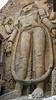
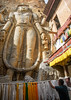
<< Text Pages >> Mulbekh Maitreya rock sculpture - Sculptured Stone in India
Submitted by KaiHofmann on Thursday, 28 July 2011 Page Views: 5358
Multi-periodSite Name: Mulbekh Maitreya rock sculptureCountry: India
NOTE: This site is 103.923 km away from the location you searched for.
Type: Sculptured Stone
Nearest Town: Kargil Nearest Village: Mulbekh
Latitude: 34.378656N Longitude: 76.366543E
Condition:
| 5 | Perfect |
| 4 | Almost Perfect |
| 3 | Reasonable but with some damage |
| 2 | Ruined but still recognisable as an ancient site |
| 1 | Pretty much destroyed, possibly visible as crop marks |
| 0 | No data. |
| -1 | Completely destroyed |
| 5 | Superb |
| 4 | Good |
| 3 | Ordinary |
| 2 | Not Good |
| 1 | Awful |
| 0 | No data. |
| 5 | Can be driven to, probably with disabled access |
| 4 | Short walk on a footpath |
| 3 | Requiring a bit more of a walk |
| 2 | A long walk |
| 1 | In the middle of nowhere, a nightmare to find |
| 0 | No data. |
| 5 | co-ordinates taken by GPS or official recorded co-ordinates |
| 4 | co-ordinates scaled from a detailed map |
| 3 | co-ordinates scaled from a bad map |
| 2 | co-ordinates of the nearest village |
| 1 | co-ordinates of the nearest town |
| 0 | no data |
Internal Links:
External Links:
Sculptured Stone in Kashmir
9 m tall Maitreya Buddha (Buddha of the Future) rock sculpture from the early buddhistic period in Kashmir.
You may be viewing yesterday's version of this page. To see the most up to date information please register for a free account.
Do not use the above information on other web sites or publications without permission of the contributor.
Nearby Images from Flickr
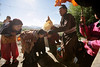
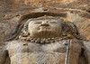
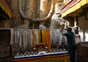
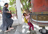
The above images may not be of the site on this page, but were taken nearby. They are loaded from Flickr so please click on them for image credits.
Click here to see more info for this site
Nearby sites
Click here to view sites on an interactive map of the areaKey: Red: member's photo, Blue: 3rd party photo, Yellow: other image, Green: no photo - please go there and take one, Grey: site destroyed
Download sites to:
KML (Google Earth)
GPX (GPS waypoints)
CSV (Garmin/Navman)
CSV (Excel)
To unlock full downloads you need to sign up as a Contributory Member. Otherwise downloads are limited to 50 sites.
Turn off the page maps and other distractions
Nearby sites listing. In the following links * = Image available
36.7km E 86° Dhomkar Rock Art* Rock Art
42.9km E 96° Khalsi Petroglyphs Rock Art
56.5km E 98° Nurla Petroglyphs Rock Art
65.5km E 96° Hemis Shukpachan engraved stone* Rock Art
65.6km E 96° Hemis Shukpachan cup marked stone* Rock Art
65.6km E 96° Hemis Shukpachan Menhir* Standing Stone (Menhir)
65.7km E 96° Hemis Shukpachen Palace* Ancient Palace
73.8km ESE 102° Alchi petroglyphs* Rock Art
76.3km ESE 103° Alchi Gompa* Ancient Temple
77.8km ESE 104° Chilungtse altar stone Carving
98.5km E 84° Camouflage Shield Stone* Rock Art
98.5km ESE 103° Taroo petroglyphs Rock Art
102.6km ENE 77° Hundar Buddha sculptured stone* Rock Art
110.6km E 80° Diskit petroglyphs* Rock Art
113.8km ESE 101° Maitreya Buddha and Avalokiteshvara rock carving* Sculptured Stone
114.6km ENE 67° Panamik Petroglyphs* Rock Art
116.3km ESE 119° Markha valley Ladakh, Shorten's (Stupa's)* Ancient Temple
118.0km ESE 105° Ladak N' India* Ancient Temple
118.3km E 88° Kardung petroglyphs* Rock Art
120.9km ESE 106° Shey buddha engravings* Carving
121.3km ESE 103° Saboo Rock* Rock Art
124.8km ESE 106° Thiksey (Kthiksey) Buddhist monestry in Ladak* Ancient Temple
126.9km ESE 107° Nyerma Monastery* Ancient Temple
139.7km W 261° Burzahom Archaeological Site Standing Stones
161.9km SE 126° TaglangLa Pass Buddhist road temple* Ancient Temple
View more nearby sites and additional images


 We would like to know more about this location. Please feel free to add a brief description and any relevant information in your own language.
 Wir möchten mehr über diese Stätte erfahren. Bitte zögern Sie nicht, eine kurze Beschreibung und relevante Informationen in Deutsch hinzuzufügen.
 Nous aimerions en savoir encore un peu sur les lieux. S'il vous plaît n'hesitez pas à ajouter une courte description et tous les renseignements pertinents dans votre propre langue.
 Quisieramos informarnos un poco más de las lugares. No dude en añadir una breve descripción y otros datos relevantes en su propio idioma.