<< Text Pages >> Balasagun stone Balbas - Sculptured Stone in Kyrgyzstan
Submitted by KaiHofmann on Thursday, 09 February 2012 Page Views: 3647
Neolithic and Bronze AgeSite Name: Balasagun stone Balbas Alternative Name: BuranaCountry: Kyrgyzstan Type: Sculptured Stone
Nearest Town: Tokmok Nearest Village: Balasagun
Latitude: 42.748106N Longitude: 75.249539E
Condition:
| 5 | Perfect |
| 4 | Almost Perfect |
| 3 | Reasonable but with some damage |
| 2 | Ruined but still recognisable as an ancient site |
| 1 | Pretty much destroyed, possibly visible as crop marks |
| 0 | No data. |
| -1 | Completely destroyed |
| 5 | Superb |
| 4 | Good |
| 3 | Ordinary |
| 2 | Not Good |
| 1 | Awful |
| 0 | No data. |
| 5 | Can be driven to, probably with disabled access |
| 4 | Short walk on a footpath |
| 3 | Requiring a bit more of a walk |
| 2 | A long walk |
| 1 | In the middle of nowhere, a nightmare to find |
| 0 | No data. |
| 5 | co-ordinates taken by GPS or official recorded co-ordinates |
| 4 | co-ordinates scaled from a detailed map |
| 3 | co-ordinates scaled from a bad map |
| 2 | co-ordinates of the nearest village |
| 1 | co-ordinates of the nearest town |
| 0 | no data |
Internal Links:
External Links:
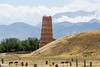
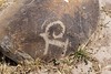
Sculptured standing stones or tomb markers of the 6th to 8th century CE.
The remains of the ancient city of Balasagun/Burana lies around the stones. The balbas (sculptured stones are collected from all over Kyrgyzstan to this place. The city was an important Silk Road station. Today, the Balbas with faces and the Burana tower are still visible.
You may be viewing yesterday's version of this page. To see the most up to date information please register for a free account.
Do not use the above information on other web sites or publications without permission of the contributor.
Nearby Images from Flickr

The above images may not be of the site on this page, but were taken nearby. They are loaded from Flickr so please click on them for image credits.
Click here to see more info for this site
Nearby sites
Click here to view sites on an interactive map of the areaKey: Red: member's photo, Blue: 3rd party photo, Yellow: other image, Green: no photo - please go there and take one, Grey: site destroyed
Download sites to:
KML (Google Earth)
GPX (GPS waypoints)
CSV (Garmin/Navman)
CSV (Excel)
To unlock full downloads you need to sign up as a Contributory Member. Otherwise downloads are limited to 50 sites.
Turn off the page maps and other distractions
Nearby sites listing. In the following links * = Image available
54.6km WNW 285° State Historical Museum of Kyrgyz Republic, Bishkek* Museum
74.6km NNE 31° Targan Barrow Cemetery Barrow Cemetery
106.0km S 174° East Song Köl Balbal* Sculptured Stone
119.6km N 11° Tamgaly Petroglyphs* Rock Art
148.6km ENE 68° The Central State Museum of the Republic of Kazakhstan* Museum
211.0km SW 215° Saimaly-Tash Rock Art
258.7km E 95° Karakol Regional Museum* Museum
259.3km E 95° Karakol Park* Sculptured Stone
272.6km ENE 60° Complex Besshatyr* Artificial Mound
336.9km SW 223° The Heavenly Horses Rock Art
357.8km SSE 166° Mor Stupas* Ancient Temple
544.9km S 180° Jirzankal cemetery* Barrow Cemetery
553.3km S 180° Tashkurgan* Ancient Village or Settlement
606.3km E 98° Kizil Caves of 1000 Buddhas* Cave or Rock Shelter
717.1km S 184° Hunza Valley Petroglyphs* Rock Art
728.8km SE 128° Karadong* Ancient Village or Settlement
742.6km NE 44° Eleke Sazy Burial Mounds* Barrow Cemetery
744.9km WSW 244° Sarazm Ancient Village or Settlement
747.8km SE 146° Dandan Oilik* Ancient Village or Settlement
765.0km S 187° Kargah Buddha* Rock Art
784.3km SE 140° Rawak* Ancient Village or Settlement
795.0km SW 221° Ai-Khanoum Ancient Village or Settlement
810.9km SW 233° Dalverzin Tepe Ancient Village or Settlement
824.1km SSW 202° Chitral Graves Ancient Village or Settlement
851.5km WSW 255° Kara-Karga* Rock Art
View more nearby sites and additional images


 We would like to know more about this location. Please feel free to add a brief description and any relevant information in your own language.
 Wir möchten mehr über diese Stätte erfahren. Bitte zögern Sie nicht, eine kurze Beschreibung und relevante Informationen in Deutsch hinzuzufügen.
 Nous aimerions en savoir encore un peu sur les lieux. S'il vous plaît n'hesitez pas à ajouter une courte description et tous les renseignements pertinents dans votre propre langue.
 Quisieramos informarnos un poco más de las lugares. No dude en añadir una breve descripción y otros datos relevantes en su propio idioma.