<< Our Photo Pages >> State Historical Museum of Kyrgyz Republic, Bishkek - Museum in Kyrgyzstan
Submitted by h_fenton on Tuesday, 26 May 2009 Page Views: 10591
MuseumsSite Name: State Historical Museum of Kyrgyz Republic, BishkekCountry: Kyrgyzstan
NOTE: This site is 188.926 km away from the location you searched for.
Type: Museum
Nearest Town: Bishkek
Latitude: 42.877374N Longitude: 74.603754E
Condition:
| 5 | Perfect |
| 4 | Almost Perfect |
| 3 | Reasonable but with some damage |
| 2 | Ruined but still recognisable as an ancient site |
| 1 | Pretty much destroyed, possibly visible as crop marks |
| 0 | No data. |
| -1 | Completely destroyed |
| 5 | Superb |
| 4 | Good |
| 3 | Ordinary |
| 2 | Not Good |
| 1 | Awful |
| 0 | No data. |
| 5 | Can be driven to, probably with disabled access |
| 4 | Short walk on a footpath |
| 3 | Requiring a bit more of a walk |
| 2 | A long walk |
| 1 | In the middle of nowhere, a nightmare to find |
| 0 | No data. |
| 5 | co-ordinates taken by GPS or official recorded co-ordinates |
| 4 | co-ordinates scaled from a detailed map |
| 3 | co-ordinates scaled from a bad map |
| 2 | co-ordinates of the nearest village |
| 1 | co-ordinates of the nearest town |
| 0 | no data |
Internal Links:
External Links:
I have visited· I would like to visit
h_fenton has visited here
")
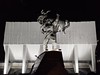
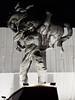
Ala-Too Square, Bishkek, Kyrgyzstan.
This used to be the Lenin Museum and still has a whole floor dedicated to him. Another floor displays recent state gifts, while there is also a floor displaying Kyrgyz History from the Neolithic onwards.
Most labelling in the museum is in Russian, although there are a few labels in English.
Displays include petroglyph's at Saimaluu Tash (3000-2000 BCE), and finds from the Ketmen-Tube Valley (2nd-4th Century CE). Judging from painted pictures on the walls there also appears to be stone circles, stone rows and single menhirs in Kyrgyzstan.
Outside the museum on the eastern side there are a number of stone Balbals – which are carved stone figures used to mark burial sites dating from 6th-10th Century CE.
You may be viewing yesterday's version of this page. To see the most up to date information please register for a free account.
")
")
")
Do not use the above information on other web sites or publications without permission of the contributor.
Nearby Images from Flickr


The above images may not be of the site on this page, but were taken nearby. They are loaded from Flickr so please click on them for image credits.
Click here to see more info for this site
Nearby sites
Click here to view sites on an interactive map of the areaKey: Red: member's photo, Blue: 3rd party photo, Yellow: other image, Green: no photo - please go there and take one, Grey: site destroyed
Download sites to:
KML (Google Earth)
GPX (GPS waypoints)
CSV (Garmin/Navman)
CSV (Excel)
To unlock full downloads you need to sign up as a Contributory Member. Otherwise downloads are limited to 50 sites.
Turn off the page maps and other distractions
Nearby sites listing. In the following links * = Image available
54.6km ESE 105° Balasagun stone Balbas Sculptured Stone
103.8km ENE 61° Targan Barrow Cemetery Barrow Cemetery
127.6km NE 36° Tamgaly Petroglyphs* Rock Art
136.2km SSE 151° East Song Köl Balbal* Sculptured Stone
194.8km ENE 77° The Central State Museum of the Republic of Kazakhstan* Museum
199.8km SSW 199° Saimaly-Tash Rock Art
312.6km E 97° Karakol Regional Museum* Museum
313.2km E 97° Karakol Park* Sculptured Stone
313.5km ENE 67° Complex Besshatyr* Artificial Mound
315.0km SW 214° The Heavenly Horses Rock Art
387.5km SSE 159° Mor Stupas* Ancient Temple
561.5km S 175° Jirzankal cemetery* Barrow Cemetery
570.1km S 175° Tashkurgan* Ancient Village or Settlement
660.5km E 98° Kizil Caves of 1000 Buddhas* Cave or Rock Shelter
705.1km WSW 240° Sarazm Ancient Village or Settlement
729.6km S 180° Hunza Valley Petroglyphs* Rock Art
770.4km NE 47° Eleke Sazy Burial Mounds* Barrow Cemetery
773.4km SW 217° Ai-Khanoum Ancient Village or Settlement
775.2km S 182° Kargah Buddha* Rock Art
778.9km SW 229° Dalverzin Tepe Ancient Village or Settlement
779.6km SE 126° Karadong* Ancient Village or Settlement
790.4km SE 143° Dandan Oilik* Ancient Village or Settlement
804.8km WSW 253° Kara-Karga* Rock Art
819.3km SSW 198° Chitral Graves Ancient Village or Settlement
829.9km SE 137° Rawak* Ancient Village or Settlement
View more nearby sites and additional images


 We would like to know more about this location. Please feel free to add a brief description and any relevant information in your own language.
 Wir möchten mehr über diese Stätte erfahren. Bitte zögern Sie nicht, eine kurze Beschreibung und relevante Informationen in Deutsch hinzuzufügen.
 Nous aimerions en savoir encore un peu sur les lieux. S'il vous plaît n'hesitez pas à ajouter une courte description et tous les renseignements pertinents dans votre propre langue.
 Quisieramos informarnos un poco más de las lugares. No dude en añadir una breve descripción y otros datos relevantes en su propio idioma.