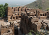
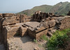
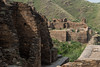
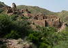
<< Our Photo Pages >> Takht-e-Bhai - Ancient Temple in Pakistan
Submitted by DrewParsons on Tuesday, 19 July 2022 Page Views: 2968
Multi-periodSite Name: Takht-e-BhaiCountry: Pakistan Type: Ancient Temple
Nearest Town: Mardan Nearest Village: Takht-e-Bhai
Latitude: 34.286340N Longitude: 71.947010E
Condition:
| 5 | Perfect |
| 4 | Almost Perfect |
| 3 | Reasonable but with some damage |
| 2 | Ruined but still recognisable as an ancient site |
| 1 | Pretty much destroyed, possibly visible as crop marks |
| 0 | No data. |
| -1 | Completely destroyed |
| 5 | Superb |
| 4 | Good |
| 3 | Ordinary |
| 2 | Not Good |
| 1 | Awful |
| 0 | No data. |
| 5 | Can be driven to, probably with disabled access |
| 4 | Short walk on a footpath |
| 3 | Requiring a bit more of a walk |
| 2 | A long walk |
| 1 | In the middle of nowhere, a nightmare to find |
| 0 | No data. |
| 5 | co-ordinates taken by GPS or official recorded co-ordinates |
| 4 | co-ordinates scaled from a detailed map |
| 3 | co-ordinates scaled from a bad map |
| 2 | co-ordinates of the nearest village |
| 1 | co-ordinates of the nearest town |
| 0 | no data |
Internal Links:
External Links:
I have visited· I would like to visit
DrewParsons has visited here
")
You may be viewing yesterday's version of this page. To see the most up to date information please register for a free account.
")
")
")
")
Do not use the above information on other web sites or publications without permission of the contributor.
Nearby Images from Flickr


The above images may not be of the site on this page, but were taken nearby. They are loaded from Flickr so please click on them for image credits.
Click here to see more info for this site
Nearby sites
Click here to view sites on an interactive map of the areaKey: Red: member's photo, Blue: 3rd party photo, Yellow: other image, Green: no photo - please go there and take one, Grey: site destroyed
Download sites to:
KML (Google Earth)
GPX (GPS waypoints)
CSV (Garmin/Navman)
CSV (Excel)
To unlock full downloads you need to sign up as a Contributory Member. Otherwise downloads are limited to 50 sites.
Turn off the page maps and other distractions
Nearby sites listing. In the following links * = Image available
36.1km E 98° Asota (Kalula) circle* Stone Circle
53.0km NNE 31° Shingardar Stupa Ancient Temple
54.6km NNE 32° Swat Buddha Sculptured Stone
54.6km NNE 32° Ghalegay Caves Cave or Rock Shelter
100.2km SE 126° Taxila Museum* Museum
113.0km ESE 122° Margalla Buddhist Caves Cave or Rock Shelter
121.1km ESE 121° Threatened Rock Shelters in Islamabad* Cave or Rock Shelter
173.2km N 355° Chitral Graves Ancient Village or Settlement
236.8km W 274° Mes Aynak Ancient Temple
268.8km E 92° Burzahom Archaeological Site Standing Stones
277.4km NE 49° Kargah Buddha* Rock Art
333.4km NE 47° Hunza Valley Petroglyphs* Rock Art
382.1km W 280° Buddhas of Bamiyan* Sculptured Stone
394.0km NW 325° Ai-Khanoum Ancient Village or Settlement
405.9km E 87° Mulbekh Maitreya rock sculpture Sculptured Stone
415.3km SSE 168° Harappa* Ancient Village or Settlement
442.6km E 87° Dhomkar Rock Art* Rock Art
448.5km E 88° Khalsi Petroglyphs Rock Art
461.9km E 88° Nurla Petroglyphs Rock Art
471.1km E 88° Hemis Shukpachan engraved stone* Rock Art
471.2km E 88° Hemis Shukpachan cup marked stone* Rock Art
471.2km E 88° Hemis Shukpachan Menhir* Standing Stone (Menhir)
471.3km E 88° Hemis Shukpachen Palace* Ancient Palace
478.4km E 89° Alchi petroglyphs* Rock Art
480.5km E 89° Alchi Gompa* Ancient Temple
View more nearby sites and additional images


 We would like to know more about this location. Please feel free to add a brief description and any relevant information in your own language.
 Wir möchten mehr über diese Stätte erfahren. Bitte zögern Sie nicht, eine kurze Beschreibung und relevante Informationen in Deutsch hinzuzufügen.
 Nous aimerions en savoir encore un peu sur les lieux. S'il vous plaît n'hesitez pas à ajouter une courte description et tous les renseignements pertinents dans votre propre langue.
 Quisieramos informarnos un poco más de las lugares. No dude en añadir una breve descripción y otros datos relevantes en su propio idioma.