

<< Our Photo Pages >> Meltingen Schalenstein - Rock Art in Switzerland in Solothurn
Submitted by Megalithic89 on Tuesday, 31 October 2023 Page Views: 198
Rock ArtSite Name: Meltingen SchalensteinCountry: Switzerland
NOTE: This site is 1.557 km away from the location you searched for.
Canton: Solothurn Type: Rock Art
Nearest Town: Solothurn
Latitude: 47.387960N Longitude: 7.589450E
Condition:
| 5 | Perfect |
| 4 | Almost Perfect |
| 3 | Reasonable but with some damage |
| 2 | Ruined but still recognisable as an ancient site |
| 1 | Pretty much destroyed, possibly visible as crop marks |
| 0 | No data. |
| -1 | Completely destroyed |
| 5 | Superb |
| 4 | Good |
| 3 | Ordinary |
| 2 | Not Good |
| 1 | Awful |
| 0 | No data. |
| 5 | Can be driven to, probably with disabled access |
| 4 | Short walk on a footpath |
| 3 | Requiring a bit more of a walk |
| 2 | A long walk |
| 1 | In the middle of nowhere, a nightmare to find |
| 0 | No data. |
| 5 | co-ordinates taken by GPS or official recorded co-ordinates |
| 4 | co-ordinates scaled from a detailed map |
| 3 | co-ordinates scaled from a bad map |
| 2 | co-ordinates of the nearest village |
| 1 | co-ordinates of the nearest town |
| 0 | no data |
Internal Links:
External Links:
")
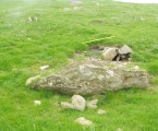
Flat block with 5 cup marks of 4 - 8 cm Ø, of which two are conical and one probably natural. A second block has been destroyed.
The stone is located at The municipal house, Hauptstrasse 54, Meltingen. This is not the site of the discovery.
References:
Swiss Inventory of Stone Monuments, http://www.ssdi.ch.
Link to SSDI Object No. 4233.01 PDF document in German.
Link to Municipality of Meltingen, History Written in German.
Note to site admins: You already have a photo of this stone, submitted on 10th October 2023 by silex1948. He (or she) put the title “Meltingen Cup Stone”. Would you please link in this photo? Thank you so much.
OK, done
You may be viewing yesterday's version of this page. To see the most up to date information please register for a free account.
Do not use the above information on other web sites or publications without permission of the contributor.
Nearby Images from Flickr

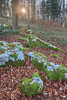
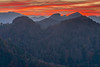
The above images may not be of the site on this page, but were taken nearby. They are loaded from Flickr so please click on them for image credits.
Click here to see more info for this site
Nearby sites
Click here to view sites on an interactive map of the areaKey: Red: member's photo, Blue: 3rd party photo, Yellow: other image, Green: no photo - please go there and take one, Grey: site destroyed
Download sites to:
KML (Google Earth)
GPX (GPS waypoints)
CSV (Garmin/Navman)
CSV (Excel)
To unlock full downloads you need to sign up as a Contributory Member. Otherwise downloads are limited to 50 sites.
Turn off the page maps and other distractions
Nearby sites listing. In the following links * = Image available
7.8km WNW 300° Laufen Dolmen* Chambered Tomb
9.1km N 350° Aesch Dolmen* Chambered Tomb
10.9km NNW 344° Summstein Ettingen Modern Stone Circle etc
14.1km SE 137° Oensingen Schalenstein* Rock Art
14.9km SSE 159° Oberbipp Dolmen* Burial Chamber or Dolmen
15.7km SSE 164° Menhir Wiedlisbach* Modern Stone Circle etc
16.1km S 173° Attiswil Freistein* Standing Stone (Menhir)
16.7km WSW 254° Pierre de Saint Germain* Rock Art
17.8km S 189° Schildchrott - Solothurner Megalithweg* Natural Stone / Erratic / Other Natural Feature
18.0km S 190° Namenloser Findling - Solothurner Megalithweg* Natural Stone / Erratic / Other Natural Feature
18.0km S 190° Chli Matterhorn - Solothurner Megalithweg* Natural Stone / Erratic / Other Natural Feature
18.0km S 189° Steinsetzungen - Solothurner Megalithweg* Natural Stone / Erratic / Other Natural Feature
18.1km SSW 193° Rüttenen Schalenstein Rock Art
18.1km S 189° Rütschelistein - Solothurner Megalithweg* Natural Stone / Erratic / Other Natural Feature
18.4km WNW 295° Saint-Joseph Abri* Cave or Rock Shelter
19.0km NNE 32° Augusta Raurica* Ancient Village or Settlement
19.4km NNE 17° Hornfels* Hillfort
21.8km SSW 210° Selzach Schalenstein* Rock Art
23.8km E 100° Archaeological Museum of the Canton of Solothurn* Museum
23.8km SSW 200° Nennigkofen Schalenstein* Rock Art
25.3km NNE 12° Burghof Museum Museum
26.5km WNW 298° Kastelberg Oppidium* Promontory Fort / Cliff Castle
26.5km SSE 164° Findling grosse Fluh* Natural Stone / Erratic / Other Natural Feature
26.9km NNE 15° Homburger Wald Grabhügelgruppe Barrow Cemetery
27.2km WSW 258° Bassecourt Menhir Standing Stone (Menhir)
View more nearby sites and additional images


 We would like to know more about this location. Please feel free to add a brief description and any relevant information in your own language.
 Wir möchten mehr über diese Stätte erfahren. Bitte zögern Sie nicht, eine kurze Beschreibung und relevante Informationen in Deutsch hinzuzufügen.
 Nous aimerions en savoir encore un peu sur les lieux. S'il vous plaît n'hesitez pas à ajouter une courte description et tous les renseignements pertinents dans votre propre langue.
 Quisieramos informarnos un poco más de las lugares. No dude en añadir una breve descripción y otros datos relevantes en su propio idioma.