<< Our Photo Pages >> Rocio Clapier - Rock Art in Italy in Piemonte
Submitted by SolarMegalith on Saturday, 09 August 2014 Page Views: 2989
Rock ArtSite Name: Rocio ClapierCountry: Italy Region: Piemonte Type: Rock Art
Latitude: 44.907617N Longitude: 7.179212E
Condition:
| 5 | Perfect |
| 4 | Almost Perfect |
| 3 | Reasonable but with some damage |
| 2 | Ruined but still recognisable as an ancient site |
| 1 | Pretty much destroyed, possibly visible as crop marks |
| 0 | No data. |
| -1 | Completely destroyed |
| 5 | Superb |
| 4 | Good |
| 3 | Ordinary |
| 2 | Not Good |
| 1 | Awful |
| 0 | No data. |
| 5 | Can be driven to, probably with disabled access |
| 4 | Short walk on a footpath |
| 3 | Requiring a bit more of a walk |
| 2 | A long walk |
| 1 | In the middle of nowhere, a nightmare to find |
| 0 | No data. |
| 5 | co-ordinates taken by GPS or official recorded co-ordinates |
| 4 | co-ordinates scaled from a detailed map |
| 3 | co-ordinates scaled from a bad map |
| 2 | co-ordinates of the nearest village |
| 1 | co-ordinates of the nearest town |
| 0 | no data |
Internal Links:
External Links:
I have visited· I would like to visit
SolarMegalith visited on 4th Aug 2014 - their rating: Cond: 4 Amb: 5 Access: 3
")
One of the most prominent cup-markd rocks of Piemonte is located on the altitude of 1230 m. This remarkable outcrop is marked with circa 100 cup-marks ("coppelle in Italian"), some of them larger and deeper than others.
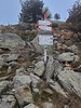
To reach Rocio Clapier follow the red trail from Sapiatti, it starts just behind the houses (the path splits into two, choose the one descending to the left, there is a wooden singpost "Rocio Clapie").
You may be viewing yesterday's version of this page. To see the most up to date information please register for a free account.
")
")
Do not use the above information on other web sites or publications without permission of the contributor.
Nearby Images from Flickr

The above images may not be of the site on this page, but were taken nearby. They are loaded from Flickr so please click on them for image credits.
Click here to see more info for this site
Nearby sites
Click here to view sites on an interactive map of the areaKey: Red: member's photo, Blue: 3rd party photo, Yellow: other image, Green: no photo - please go there and take one, Grey: site destroyed
Download sites to:
KML (Google Earth)
GPX (GPS waypoints)
CSV (Garmin/Navman)
CSV (Excel)
To unlock full downloads you need to sign up as a Contributory Member. Otherwise downloads are limited to 50 sites.
Turn off the page maps and other distractions
Nearby sites listing. In the following links * = Image available
4.5km WSW 248° Roccia del Mago* Rock Art
22.7km ENE 57° Bosco de Celti* Henge
28.6km NNW 328° Necropolis la Maddalena* Barrow Cemetery
28.8km NNW 328° Museo e Area Archeologica della Maddalena di Chiomonte Museum
31.7km WSW 241° Menhir dit la Pierre Fiche (Ville-Vieille) Standing Stone (Menhir)
43.6km NE 38° Dreamland* Modern Stone Circle etc
43.6km ENE 66° Museo Egizio* Museum
44.0km W 273° Pierre à cupules dite la Pierre aux Oeufs Rock Art
45.4km NNW 337° Pierre Gravée (Crosats) Rock Art
46.1km NNW 338° La Pierre des Saints Rock Art
46.5km NNW 334° Pierre Gravée (St Pierre) Rock Art
48.8km NW 317° Parc archéologique des Lozes Rock Art
48.9km NW 323° Musée Archéologique (Sollieres) Museum
49.6km NW 320° Sardieres Monolithe Natural Stone / Erratic / Other Natural Feature
50.2km WSW 250° Roche de Rame Sepulture Cave or Rock Shelter
50.2km NNW 335° La Pierre aux Pieds Rock Art
50.2km NNW 335° Pierre à Cupules dite Le Rocher aux Pieds Rock Art
50.3km NNW 346° Les Peintures du Rocher du Château* Rock Art
50.3km WSW 250° La Roche-de-Rame Sepulture Ancient Village or Settlement
50.6km SSE 165° Rocce Re Rock Art
52.6km WSW 248° Grotte de Rame Cave or Rock Shelter
61.2km WSW 238° Dolmen de Chateauroux Burial Chamber or Dolmen
63.7km ENE 60° Chivasso Menhir* Standing Stone (Menhir)
64.2km WNW 304° Dolmen du Thyl* Cave or Rock Shelter
64.3km WNW 303° Roche gravée du Thyl-Dessous Rock Art
View more nearby sites and additional images


 We would like to know more about this location. Please feel free to add a brief description and any relevant information in your own language.
 Wir möchten mehr über diese Stätte erfahren. Bitte zögern Sie nicht, eine kurze Beschreibung und relevante Informationen in Deutsch hinzuzufügen.
 Nous aimerions en savoir encore un peu sur les lieux. S'il vous plaît n'hesitez pas à ajouter une courte description et tous les renseignements pertinents dans votre propre langue.
 Quisieramos informarnos un poco más de las lugares. No dude en añadir una breve descripción y otros datos relevantes en su propio idioma.