

<< Our Photo Pages >> Les Peintures du Rocher du Château - Rock Art in France in Rhone:Savoie (73)
Submitted by DrewParsons on Monday, 28 December 2009 Page Views: 5932
Rock ArtSite Name: Les Peintures du Rocher du ChâteauCountry: France
NOTE: This site is 9.433 km away from the location you searched for.
Département: Rhone:Savoie (73) Type: Rock Art
Nearest Town: Bessans Nearest Village: le Villaron
Latitude: 45.346970N Longitude: 7.027080E
Condition:
| 5 | Perfect |
| 4 | Almost Perfect |
| 3 | Reasonable but with some damage |
| 2 | Ruined but still recognisable as an ancient site |
| 1 | Pretty much destroyed, possibly visible as crop marks |
| 0 | No data. |
| -1 | Completely destroyed |
| 5 | Superb |
| 4 | Good |
| 3 | Ordinary |
| 2 | Not Good |
| 1 | Awful |
| 0 | No data. |
| 5 | Can be driven to, probably with disabled access |
| 4 | Short walk on a footpath |
| 3 | Requiring a bit more of a walk |
| 2 | A long walk |
| 1 | In the middle of nowhere, a nightmare to find |
| 0 | No data. |
| 5 | co-ordinates taken by GPS or official recorded co-ordinates |
| 4 | co-ordinates scaled from a detailed map |
| 3 | co-ordinates scaled from a bad map |
| 2 | co-ordinates of the nearest village |
| 1 | co-ordinates of the nearest town |
| 0 | no data |
Internal Links:
External Links:
I have visited· I would like to visit
DrewParsons has visited here
")
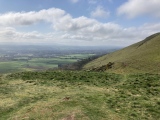
The valley has been free of ice for the last 10000 to 12000 years and evidence of human habitation has been found tracing activity here back to 5000 BC. The rock shelter at the base of the cliff provided a panel for art works whilst the rock itself contained serpentine useful for making tools. The site is reached on a footpath from le Villaron village which is north of Bessans. There is a car park on the D902 on the east bank of the l'Arc river at le Villaron and after crossing the bridge turn right (north east) and follow the footpath along the true right bank of the river (west bank) for 2 kilometres to reach the well signed site. It's a site for enthusiasts as the paintings are very indistinct, but nevertheless it's an important link to our past and worth a visit. The trail is a pleasant walk along the river with fine views to the mountains on both sides of the valley. At the site keep behind the fence line and use a telephoto for close up photos as the site is very fragile.
You may be viewing yesterday's version of this page. To see the most up to date information please register for a free account.
")
")
")
")
")
")
")
")
")
Do not use the above information on other web sites or publications without permission of the contributor.
Click here to see more info for this site
Nearby sites
Click here to view sites on an interactive map of the areaKey: Red: member's photo, Blue: 3rd party photo, Yellow: other image, Green: no photo - please go there and take one, Grey: site destroyed
Download sites to:
KML (Google Earth)
GPX (GPS waypoints)
CSV (Garmin/Navman)
CSV (Excel)
To unlock full downloads you need to sign up as a Contributory Member. Otherwise downloads are limited to 50 sites.
Turn off the page maps and other distractions
Nearby sites listing. In the following links * = Image available
8.2km SW 222° La Pierre des Saints Rock Art
9.4km SW 220° Pierre Gravée (Crosats) Rock Art
10.1km WSW 250° Pierre à Cupules dite Le Rocher aux Pieds Rock Art
10.1km WSW 250° La Pierre aux Pieds Rock Art
10.9km SW 230° Pierre Gravée (St Pierre) Rock Art
16.4km NW 311° Col des Ves* Standing Stone (Menhir)
19.9km WSW 241° Musée Archéologique (Sollieres) Museum
23.1km WSW 241° Sardieres Monolithe Natural Stone / Erratic / Other Natural Feature
24.6km S 187° Museo e Area Archeologica della Maddalena di Chiomonte Museum
24.7km S 187° Necropolis la Maddalena* Barrow Cemetery
25.1km WSW 238° Parc archéologique des Lozes Rock Art
29.2km WNW 293° Champagny 1 Rock Art
30.2km WNW 292° Tincave 1 Rock Art
31.0km WNW 291° Tincave 2 Rock Art
31.1km WNW 289° Site du Moulin de Bozel Ancient Village or Settlement
32.3km W 280° Menhir des Verdons* Standing Stone (Menhir)
33.3km NW 308° Dolmen de Nantfrozin Burial Chamber or Dolmen
38.7km NNW 343° Col du Petit Saint-Bernard Cromlech* Stone Circle
38.7km NNW 343° Cromlech del Piccolo San Bernardo* Stone Circle
40.3km WNW 291° Pierre de Feisson Rock Art
40.3km WNW 291° Pierre à cupules de Feisson sur Salin Rock Art
41.5km ESE 111° Dreamland* Modern Stone Circle etc
43.5km WSW 253° Pierre à Cupules du Perthuit Rock Art
43.6km WSW 253° Pierre à Cupules du Pré Bérard Rock Art
43.8km WSW 252° Dolmen du Thyl* Cave or Rock Shelter
View more nearby sites and additional images


 We would like to know more about this location. Please feel free to add a brief description and any relevant information in your own language.
 Wir möchten mehr über diese Stätte erfahren. Bitte zögern Sie nicht, eine kurze Beschreibung und relevante Informationen in Deutsch hinzuzufügen.
 Nous aimerions en savoir encore un peu sur les lieux. S'il vous plaît n'hesitez pas à ajouter une courte description et tous les renseignements pertinents dans votre propre langue.
 Quisieramos informarnos un poco más de las lugares. No dude en añadir una breve descripción y otros datos relevantes en su propio idioma.