<< Text Pages >> Sarazm - Ancient Village or Settlement in Tajikistan
Submitted by davidmorgan on Wednesday, 28 June 2017 Page Views: 1783
Multi-periodSite Name: SarazmCountry: Tajikistan
NOTE: This site is 257.837 km away from the location you searched for.
Type: Ancient Village or Settlement
Nearest Town: Panjakent
Latitude: 39.508000N Longitude: 67.460000E
Condition:
| 5 | Perfect |
| 4 | Almost Perfect |
| 3 | Reasonable but with some damage |
| 2 | Ruined but still recognisable as an ancient site |
| 1 | Pretty much destroyed, possibly visible as crop marks |
| 0 | No data. |
| -1 | Completely destroyed |
| 5 | Superb |
| 4 | Good |
| 3 | Ordinary |
| 2 | Not Good |
| 1 | Awful |
| 0 | No data. |
| 5 | Can be driven to, probably with disabled access |
| 4 | Short walk on a footpath |
| 3 | Requiring a bit more of a walk |
| 2 | A long walk |
| 1 | In the middle of nowhere, a nightmare to find |
| 0 | No data. |
| 5 | co-ordinates taken by GPS or official recorded co-ordinates |
| 4 | co-ordinates scaled from a detailed map |
| 3 | co-ordinates scaled from a bad map |
| 2 | co-ordinates of the nearest village |
| 1 | co-ordinates of the nearest town |
| 0 | no data |
Internal Links:
External Links:
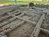
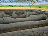
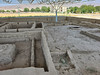
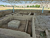
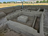
Ancient Settlement in Tajikistan
An Early Bronze Age settlement with 4 major phases dating between 3500 and 2000 BCE.
A UNESCO World Heritage site: Proto-urban Site of Sarazm.
You may be viewing yesterday's version of this page. To see the most up to date information please register for a free account.
Do not use the above information on other web sites or publications without permission of the contributor.
Nearby Images from Flickr
The above images may not be of the site on this page, but were taken nearby. They are loaded from Flickr so please click on them for image credits.
Click here to see more info for this site
Nearby sites
Click here to view sites on an interactive map of the areaKey: Red: member's photo, Blue: 3rd party photo, Yellow: other image, Green: no photo - please go there and take one, Grey: site destroyed
Download sites to:
KML (Google Earth)
GPX (GPS waypoints)
CSV (Garmin/Navman)
CSV (Excel)
To unlock full downloads you need to sign up as a Contributory Member. Otherwise downloads are limited to 50 sites.
Turn off the page maps and other distractions
Nearby sites listing. In the following links * = Image available
160.4km SSE 167° Dalverzin Tepe Ancient Village or Settlement
192.7km WNW 301° Kara-Karga* Rock Art
236.3km S 189° Kampirtepa Ancient Village or Settlement
262.8km W 278° Bukhara Ark* Ancient Village or Settlement
310.6km SE 146° Ai-Khanoum Ancient Village or Settlement
344.8km SSW 206° Tillia tepe Artificial Mound
444.5km ENE 74° The Heavenly Horses Rock Art
491.0km WSW 255° Gonur Tepe* Ancient Village or Settlement
501.6km WSW 248° Merv, Turkmenistan* Ancient Village or Settlement
521.0km S 176° Buddhas of Bamiyan* Sculptured Stone
557.9km SE 136° Chitral Graves Ancient Village or Settlement
569.5km ENE 69° Saimaly-Tash Rock Art
590.5km WNW 297° Koi Krylgan Kala Ancient Temple
592.8km SSE 163° Mes Aynak Ancient Temple
642.8km NNW 330° Magazine Hill Artificial Mound
682.7km SE 140° Ghalegay Caves Cave or Rock Shelter
682.8km SE 140° Swat Buddha Sculptured Stone
683.2km SE 140° Shingardar Stupa Ancient Temple
696.8km ESE 103° Jirzankal cemetery* Barrow Cemetery
701.2km ESE 104° Tashkurgan* Ancient Village or Settlement
704.3km SE 144° Takht-e-Bhai* Ancient Temple
705.1km NE 56° State Historical Museum of Kyrgyz Republic, Bishkek* Museum
715.9km ENE 67° East Song Köl Balbal* Sculptured Stone
719.4km ESE 122° Kargah Buddha* Rock Art
723.6km ESE 117° Hunza Valley Petroglyphs* Rock Art
View more nearby sites and additional images


 We would like to know more about this location. Please feel free to add a brief description and any relevant information in your own language.
 Wir möchten mehr über diese Stätte erfahren. Bitte zögern Sie nicht, eine kurze Beschreibung und relevante Informationen in Deutsch hinzuzufügen.
 Nous aimerions en savoir encore un peu sur les lieux. S'il vous plaît n'hesitez pas à ajouter une courte description et tous les renseignements pertinents dans votre propre langue.
 Quisieramos informarnos un poco más de las lugares. No dude en añadir una breve descripción y otros datos relevantes en su propio idioma.