

<< Our Photo Pages >> Dolmen de Quintal - Burial Chamber or Dolmen in France in Rhone:Haute-Savoie (74)
Submitted by TheCaptain on Wednesday, 08 September 2010 Page Views: 3707
Neolithic and Bronze AgeSite Name: Dolmen de QuintalCountry: France
NOTE: This site is 14.543 km away from the location you searched for.
Département: Rhone:Haute-Savoie (74) Type: Burial Chamber or Dolmen
Nearest Town: Annecy Nearest Village: Quintal
Latitude: 45.841000N Longitude: 6.085000E
Condition:
| 5 | Perfect |
| 4 | Almost Perfect |
| 3 | Reasonable but with some damage |
| 2 | Ruined but still recognisable as an ancient site |
| 1 | Pretty much destroyed, possibly visible as crop marks |
| 0 | No data. |
| -1 | Completely destroyed |
| 5 | Superb |
| 4 | Good |
| 3 | Ordinary |
| 2 | Not Good |
| 1 | Awful |
| 0 | No data. |
| 5 | Can be driven to, probably with disabled access |
| 4 | Short walk on a footpath |
| 3 | Requiring a bit more of a walk |
| 2 | A long walk |
| 1 | In the middle of nowhere, a nightmare to find |
| 0 | No data. |
| 5 | co-ordinates taken by GPS or official recorded co-ordinates |
| 4 | co-ordinates scaled from a detailed map |
| 3 | co-ordinates scaled from a bad map |
| 2 | co-ordinates of the nearest village |
| 1 | co-ordinates of the nearest town |
| 0 | no data |
Be the first person to rate this site - see the 'Contribute!' box in the right hand menu.
Internal Links:
External Links:
")
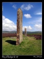
Dolmen de Quintal is a burial chamber in the community of Quintal, Departement of Haute-Savoie, Region of Rhône-Alps
You may be viewing yesterday's version of this page. To see the most up to date information please register for a free account.
Do not use the above information on other web sites or publications without permission of the contributor.
Nearby Images from Flickr
The above images may not be of the site on this page, but were taken nearby. They are loaded from Flickr so please click on them for image credits.
Click here to see more info for this site
Nearby sites
Click here to view sites on an interactive map of the areaKey: Red: member's photo, Blue: 3rd party photo, Yellow: other image, Green: no photo - please go there and take one, Grey: site destroyed
Download sites to:
KML (Google Earth)
GPX (GPS waypoints)
CSV (Garmin/Navman)
CSV (Excel)
To unlock full downloads you need to sign up as a Contributory Member. Otherwise downloads are limited to 50 sites.
Turn off the page maps and other distractions
Nearby sites listing. In the following links * = Image available
24.1km WSW 238° Pierre à Cupules de Santourin Rock Art
24.7km WSW 240° Blocs Cupulaires des Follioules Rock Art
26.1km WSW 238° Pierre à Cupules de la Roche Rock Art
28.0km SSW 195° Mont Peney Rock Art
32.3km SSW 192° Grotte des Fées (Curienne) Cave or Rock Shelter
32.7km NNE 25° Dolmen de Pers-Jussy Burial Chamber or Dolmen
35.9km NNE 26° La Pierre aux Fées (Reignier)* Burial Chamber or Dolmen
35.9km N 8° Troinex Menhirs* Standing Stone (Menhir)
37.0km S 189° Chignin Menhir* Standing Stone (Menhir)
38.7km NNE 16° Dolmen de Etrembieres Burial Chamber or Dolmen
40.2km N 7° Pierre-aux-Dames Rock Art
45.2km NNE 26° Dolmen de Cranves-Sales Burial Chamber or Dolmen
45.5km NNE 22° La Cave Aux Fées (St-Cergues)* Burial Chamber or Dolmen
47.2km N 3° Zeichenstein von Bois Prodom Rock Art
49.0km SSW 208° Grottes des Echelles Cave or Rock Shelter
51.7km N 4° Chavannes-des-Bois Menhir* Standing Stone (Menhir)
52.1km NNE 25° Dolmen de Bons-en-Chablais Burial Chamber or Dolmen
52.7km SW 215° Dolmen dit la Pierre à Mata Burial Chamber or Dolmen
54.2km SE 139° Pierre de Feisson Rock Art
54.2km SE 139° Pierre à cupules de Feisson sur Salin Rock Art
55.6km N 2° Menhir du Mont-Mourex Standing Stone (Menhir)
57.8km W 272° Grottes de la Balme* Cave or Rock Shelter
58.3km SE 126° Dolmen de Nantfrozin Burial Chamber or Dolmen
58.8km NNE 22° Pierre a Cupules (Sciez) Rock Art
58.8km NNE 16° Pierre a Cupules (Messery) Rock Art
View more nearby sites and additional images


 We would like to know more about this location. Please feel free to add a brief description and any relevant information in your own language.
 Wir möchten mehr über diese Stätte erfahren. Bitte zögern Sie nicht, eine kurze Beschreibung und relevante Informationen in Deutsch hinzuzufügen.
 Nous aimerions en savoir encore un peu sur les lieux. S'il vous plaît n'hesitez pas à ajouter une courte description et tous les renseignements pertinents dans votre propre langue.
 Quisieramos informarnos un poco más de las lugares. No dude en añadir una breve descripción y otros datos relevantes en su propio idioma.