<< Text Pages >> La Côte de Drince Oppidum - Ancient Village or Settlement in France in Alsace-Lorraine:Moselle (57)
Submitted by KaiHofmann on Monday, 13 March 2017 Page Views: 965
Multi-periodSite Name: La Côte de Drince OppidumCountry: France Département: Alsace-Lorraine:Moselle (57) Type: Ancient Village or Settlement
Nearest Town: Metz Nearest Village: Pierrevillers
Latitude: 49.225380N Longitude: 6.087571E
Condition:
| 5 | Perfect |
| 4 | Almost Perfect |
| 3 | Reasonable but with some damage |
| 2 | Ruined but still recognisable as an ancient site |
| 1 | Pretty much destroyed, possibly visible as crop marks |
| 0 | No data. |
| -1 | Completely destroyed |
| 5 | Superb |
| 4 | Good |
| 3 | Ordinary |
| 2 | Not Good |
| 1 | Awful |
| 0 | No data. |
| 5 | Can be driven to, probably with disabled access |
| 4 | Short walk on a footpath |
| 3 | Requiring a bit more of a walk |
| 2 | A long walk |
| 1 | In the middle of nowhere, a nightmare to find |
| 0 | No data. |
| 5 | co-ordinates taken by GPS or official recorded co-ordinates |
| 4 | co-ordinates scaled from a detailed map |
| 3 | co-ordinates scaled from a bad map |
| 2 | co-ordinates of the nearest village |
| 1 | co-ordinates of the nearest town |
| 0 | no data |
Internal Links:
External Links:
Ancient Village or Settlement in Alsace-Lorraine:Moselle (57)
A Gallo-Roman Oppidum on the Côte de Drince hill.
You may be viewing yesterday's version of this page. To see the most up to date information please register for a free account.
Do not use the above information on other web sites or publications without permission of the contributor.
Nearby Images from Flickr
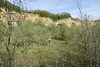


The above images may not be of the site on this page, but were taken nearby. They are loaded from Flickr so please click on them for image credits.
Click here to see more info for this site
Nearby sites
Click here to view sites on an interactive map of the areaKey: Red: member's photo, Blue: 3rd party photo, Yellow: other image, Green: no photo - please go there and take one, Grey: site destroyed
Download sites to:
KML (Google Earth)
GPX (GPS waypoints)
CSV (Garmin/Navman)
CSV (Excel)
To unlock full downloads you need to sign up as a Contributory Member. Otherwise downloads are limited to 50 sites.
Turn off the page maps and other distractions
Nearby sites listing. In the following links * = Image available
1.0km NNE 23° La pierre qui tourne Pierrevillers Standing Stone (Menhir)
5.8km NE 54° Archéosite Celte Museum
9.6km SSE 165° Lorry-les-Metz burial chamber Burial Chamber or Dolmen
10.8km S 185° Mont-Saint-Germain Hillfort
11.8km NNW 346° Eperon barré du bois des Chênes Hillfort
12.7km SW 235° Fontaine des Bons Malades Holy Well or Sacred Spring
16.4km S 175° Croix-St-Clement Burial Chamber or Dolmen
20.0km S 190° La Pierre qui tourne Ancy-Sur-Moselle Natural Stone / Erratic / Other Natural Feature
20.6km S 188° Rochers-de-la-Frasse Cave or Rock Shelter
22.4km S 188° Mont Jouy Burial Chamber or Dolmen
23.5km ENE 65° Nonnenfels* Rock Art
24.2km S 190° Le Rudemont Cave or Rock Shelter
24.4km SSW 197° Le Trou-des-Fées Cave or Rock Shelter
28.7km NNW 340° Nécropole Mérovingienne Audun-le-Tiche Barrow Cemetery
31.4km N 10° Aalburg Befort* Hillfort
31.6km NE 49° Stèle de Paffenacker* Standing Stone (Menhir)
33.5km S 190° La Pierre-au-Jô Menhir* Standing Stone (Menhir)
33.7km E 89° Nécropole tumulaire de Téterchen Barrow Cemetery
37.0km NNE 19° Vicus Ricciaco* Ancient Village or Settlement
37.6km ENE 67° Grabhuegelfeld Niedaltdorf Barrow Cemetery
39.0km NE 53° Site des Menhirs de l´Europe Modern Stone Circle etc
39.3km NE 40° Hunnenschanze Borg Misc. Earthwork
39.5km NNE 32° Molknopp* Round Barrow(s)
39.6km ENE 72° Sudelfels* Holy Well or Sacred Spring
39.7km NE 54° Steine an der Grenze Modern Stone Circle etc
View more nearby sites and additional images


 We would like to know more about this location. Please feel free to add a brief description and any relevant information in your own language.
 Wir möchten mehr über diese Stätte erfahren. Bitte zögern Sie nicht, eine kurze Beschreibung und relevante Informationen in Deutsch hinzuzufügen.
 Nous aimerions en savoir encore un peu sur les lieux. S'il vous plaît n'hesitez pas à ajouter une courte description et tous les renseignements pertinents dans votre propre langue.
 Quisieramos informarnos un poco más de las lugares. No dude en añadir una breve descripción y otros datos relevantes en su propio idioma.