 with our Megalithic Portal iPhone app")

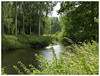
<< Our Photo Pages >> Vinke Posterholt - Barrow Cemetery in Netherlands in Limburg
Submitted by Shunt on Friday, 27 June 2008 Page Views: 4856
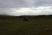
Neolithic and Bronze AgeSite Name: Vinke Posterholt Alternative Name: Aan Hommen, Klodot, FinnkeCountry: Netherlands
NOTE: This site is 6.66 km away from the location you searched for.
Province: Limburg Type: Barrow Cemetery
Nearest Village: Posterholt
Latitude: 51.121704N Longitude: 6.077027E
Condition:
| 5 | Perfect |
| 4 | Almost Perfect |
| 3 | Reasonable but with some damage |
| 2 | Ruined but still recognisable as an ancient site |
| 1 | Pretty much destroyed, possibly visible as crop marks |
| 0 | No data. |
| -1 | Completely destroyed |
| 5 | Superb |
| 4 | Good |
| 3 | Ordinary |
| 2 | Not Good |
| 1 | Awful |
| 0 | No data. |
| 5 | Can be driven to, probably with disabled access |
| 4 | Short walk on a footpath |
| 3 | Requiring a bit more of a walk |
| 2 | A long walk |
| 1 | In the middle of nowhere, a nightmare to find |
| 0 | No data. |
| 5 | co-ordinates taken by GPS or official recorded co-ordinates |
| 4 | co-ordinates scaled from a detailed map |
| 3 | co-ordinates scaled from a bad map |
| 2 | co-ordinates of the nearest village |
| 1 | co-ordinates of the nearest town |
| 0 | no data |
Internal Links:
External Links:
")
On this site several excavations dug up many things such as bracelets, razorblades, pottery etc. dating from the late Bronze Age and Iron Age. It was only discovered recently that this mound was a burial mound.
Take a look at this website for some real nice pictures.
You may be viewing yesterday's version of this page. To see the most up to date information please register for a free account.
")
Do not use the above information on other web sites or publications without permission of the contributor.
Nearby Images from Flickr

The above images may not be of the site on this page, but were taken nearby. They are loaded from Flickr so please click on them for image credits.
Click here to see more info for this site
Nearby sites
Click here to view sites on an interactive map of the areaKey: Red: member's photo, Blue: 3rd party photo, Yellow: other image, Green: no photo - please go there and take one, Grey: site destroyed
Download sites to:
KML (Google Earth)
GPX (GPS waypoints)
CSV (Garmin/Navman)
CSV (Excel)
To unlock full downloads you need to sign up as a Contributory Member. Otherwise downloads are limited to 50 sites.
Turn off the page maps and other distractions
Nearby sites listing. In the following links * = Image available
2.8km NW 309° Posterholt (45733) Ancient Village or Settlement
3.2km ENE 69° Grabhügelgruppe Schleidbahn Barrow Cemetery
4.0km ENE 76° Grabhügel Frankenstrasse Round Barrow(s)
4.1km ENE 72° Grabhügel Keltenstrasse Round Barrow(s)
5.4km N 4° Herkenbosch (340950) Ancient Village or Settlement
5.7km ENE 74° Grabhügel Vickesheider Weg Round Barrow(s)
5.7km ENE 73° Grabhügelgruppe Rödger Bahn Barrow Cemetery
8.6km N 360° Grabhügel VIE 059* Round Barrow(s)
8.6km NW 320° O.L. Vrouweput in Kapel het Zand Holy Well or Sacred Spring
12.0km N 355° Grafheuvel Swalmen (46021)* Round Barrow(s)
12.0km N 356° Grafheuvel Swalmen (46022)* Round Barrow(s)
13.6km N 358° Swalmen* Barrow Cemetery
16.2km NNW 332° Servaasput, Nunhem Holy Well or Sacred Spring
16.8km SW 221° Grabhügelgruppe in der Westerheide Barrow Cemetery
17.2km NNE 24° Grabhügel Brüggener Wald* Round Barrow(s)
17.6km NW 320° Grafheuvels en Urnenveld Haelen (47112)* Round Barrow(s)
17.7km NW 320° De Busschop (531045) Ancient Village or Settlement
19.5km ENE 68° Grabhügelfeld Hardt* Barrow Cemetery
20.2km W 262° Regionaal archeologisch museum* Museum
20.3km NNW 345° Helden (45566) Ancient Village or Settlement
20.4km E 84° Archäologisches Museum Wasserturm Rheindahlen* Museum
20.4km NW 308° Baexem (340668) Ancient Village or Settlement
21.4km N 359° Maasbree (45733) Ancient Village or Settlement
25.2km SW 220° Sweikhuizen (341113) Ancient Village or Settlement
25.2km NE 53° Viersener Steinlabyrinth* Turf Maze
View more nearby sites and additional images


 We would like to know more about this location. Please feel free to add a brief description and any relevant information in your own language.
 Wir möchten mehr über diese Stätte erfahren. Bitte zögern Sie nicht, eine kurze Beschreibung und relevante Informationen in Deutsch hinzuzufügen.
 Nous aimerions en savoir encore un peu sur les lieux. S'il vous plaît n'hesitez pas à ajouter une courte description et tous les renseignements pertinents dans votre propre langue.
 Quisieramos informarnos un poco más de las lugares. No dude en añadir una breve descripción y otros datos relevantes en su propio idioma.