

<< Text Pages >> Le Trou-des-Fées - Cave or Rock Shelter in France in Alsace-Lorraine:Meurthe-et-Moselle
Submitted by TheCaptain on Wednesday, 08 September 2010 Page Views: 1885
Natural PlacesSite Name: Le Trou-des-FéesCountry: France
NOTE: This site is 2.43 km away from the location you searched for.
Département: Alsace-Lorraine:Meurthe-et-Moselle Type: Cave or Rock Shelter
Nearest Town: Metz Nearest Village: Bayonville
Latitude: 49.015000N Longitude: 5.991000E
Condition:
| 5 | Perfect |
| 4 | Almost Perfect |
| 3 | Reasonable but with some damage |
| 2 | Ruined but still recognisable as an ancient site |
| 1 | Pretty much destroyed, possibly visible as crop marks |
| 0 | No data. |
| -1 | Completely destroyed |
| 5 | Superb |
| 4 | Good |
| 3 | Ordinary |
| 2 | Not Good |
| 1 | Awful |
| 0 | No data. |
| 5 | Can be driven to, probably with disabled access |
| 4 | Short walk on a footpath |
| 3 | Requiring a bit more of a walk |
| 2 | A long walk |
| 1 | In the middle of nowhere, a nightmare to find |
| 0 | No data. |
| 5 | co-ordinates taken by GPS or official recorded co-ordinates |
| 4 | co-ordinates scaled from a detailed map |
| 3 | co-ordinates scaled from a bad map |
| 2 | co-ordinates of the nearest village |
| 1 | co-ordinates of the nearest town |
| 0 | no data |
Be the first person to rate this site - see the 'Contribute!' box in the right hand menu.
Internal Links:
External Links:
Grotte Sepulcrale in Alsace:Meurthe-et-Moselle (54)
Le Trou-des-Fées is a Grotte Sepulcrale in the community of Bayonville, Departement of Meurthe-et-Moselle, Region of Alsace-Lorraine
You may be viewing yesterday's version of this page. To see the most up to date information please register for a free account.
Do not use the above information on other web sites or publications without permission of the contributor.
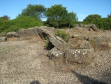
Nearby Images from Flickr
The above images may not be of the site on this page, but were taken nearby. They are loaded from Flickr so please click on them for image credits.
Click here to see more info for this site
Nearby sites
Click here to view sites on an interactive map of the areaKey: Red: member's photo, Blue: 3rd party photo, Yellow: other image, Green: no photo - please go there and take one, Grey: site destroyed
Download sites to:
KML (Google Earth)
GPX (GPS waypoints)
CSV (Garmin/Navman)
CSV (Excel)
To unlock full downloads you need to sign up as a Contributory Member. Otherwise downloads are limited to 50 sites.
Turn off the page maps and other distractions
Nearby sites listing. In the following links * = Image available
3.0km E 99° Le Rudemont Cave or Rock Shelter
4.1km ENE 72° Mont Jouy Burial Chamber or Dolmen
5.1km NE 54° Rochers-de-la-Frasse Cave or Rock Shelter
5.2km NE 44° La Pierre qui tourne Ancy-Sur-Moselle Natural Stone / Erratic / Other Natural Feature
9.7km S 171° La Pierre-au-Jô Menhir* Standing Stone (Menhir)
10.9km NE 50° Croix-St-Clement Burial Chamber or Dolmen
14.0km NNE 25° Mont-Saint-Germain Hillfort
16.4km NNW 348° Fontaine des Bons Malades Holy Well or Sacred Spring
17.0km NE 34° Lorry-les-Metz burial chamber Burial Chamber or Dolmen
24.4km NNE 17° La Côte de Drince Oppidum Ancient Village or Settlement
24.7km SE 146° Le Trou-du-Chien Cave or Rock Shelter
25.5km NNE 17° La pierre qui tourne Pierrevillers Standing Stone (Menhir)
27.6km WSW 242° Woinville Menhir* Standing Stone (Menhir)
29.2km NNE 24° Archéosite Celte Museum
29.6km WSW 246° La Dame Schone Menhir* Standing Stone (Menhir)
29.7km S 170° La Garenne (Liverdun) Burial Chamber or Dolmen
33.5km ESE 110° Tincry Oppidum protohistorique Ancient Village or Settlement
34.9km SSE 159° Enceinte préhistorique de la Fourasse Ancient Village or Settlement
35.1km N 7° Eperon barré du bois des Chênes Hillfort
35.6km WSW 248° La Cote-de-Bar Cave or Rock Shelter
36.3km WSW 248° La Grosse Borne (Chauvoncourt)* Standing Stone (Menhir)
36.4km WSW 245° Le Camp des Romains Ancient Village or Settlement
37.4km SSE 152° Oppidum Sainte-Geneviève Ancient Village or Settlement
39.2km S 178° Grotte du Géant Cave or Rock Shelter
40.4km WSW 238° La Pierre Trouée * Standing Stone (Menhir)
View more nearby sites and additional images


 We would like to know more about this location. Please feel free to add a brief description and any relevant information in your own language.
 Wir möchten mehr über diese Stätte erfahren. Bitte zögern Sie nicht, eine kurze Beschreibung und relevante Informationen in Deutsch hinzuzufügen.
 Nous aimerions en savoir encore un peu sur les lieux. S'il vous plaît n'hesitez pas à ajouter une courte description et tous les renseignements pertinents dans votre propre langue.
 Quisieramos informarnos un poco más de las lugares. No dude en añadir una breve descripción y otros datos relevantes en su propio idioma.