<< Other Photo Pages >> Pierrefiche Menhir - Standing Stone (Menhir) in France in Rhone:Ain (01)
Submitted by AlexHunger on Tuesday, 07 June 2005 Page Views: 4341
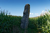
Neolithic and Bronze AgeSite Name: Pierrefiche MenhirCountry: France Département: Rhone:Ain (01) Type: Standing Stone (Menhir)
Nearest Town: Bourg-En-Bresse Nearest Village: Simandre-sur-Suran
Latitude: 46.232584N Longitude: 5.421653E
Condition:
| 5 | Perfect |
| 4 | Almost Perfect |
| 3 | Reasonable but with some damage |
| 2 | Ruined but still recognisable as an ancient site |
| 1 | Pretty much destroyed, possibly visible as crop marks |
| 0 | No data. |
| -1 | Completely destroyed |
| 5 | Superb |
| 4 | Good |
| 3 | Ordinary |
| 2 | Not Good |
| 1 | Awful |
| 0 | No data. |
| 5 | Can be driven to, probably with disabled access |
| 4 | Short walk on a footpath |
| 3 | Requiring a bit more of a walk |
| 2 | A long walk |
| 1 | In the middle of nowhere, a nightmare to find |
| 0 | No data. |
| 5 | co-ordinates taken by GPS or official recorded co-ordinates |
| 4 | co-ordinates scaled from a detailed map |
| 3 | co-ordinates scaled from a bad map |
| 2 | co-ordinates of the nearest village |
| 1 | co-ordinates of the nearest town |
| 0 | no data |
Internal Links:
External Links:
Menhir in Ain
You may be viewing yesterday's version of this page. To see the most up to date information please register for a free account.
Do not use the above information on other web sites or publications without permission of the contributor.
davidmorgan has found this location on Google Street View:
Nearby Images from Flickr
The above images may not be of the site on this page, but were taken nearby. They are loaded from Flickr so please click on them for image credits.
Click here to see more info for this site
Nearby sites
Click here to view sites on an interactive map of the areaKey: Red: member's photo, Blue: 3rd party photo, Yellow: other image, Green: no photo - please go there and take one, Grey: site destroyed
Download sites to:
KML (Google Earth)
GPX (GPS waypoints)
CSV (Garmin/Navman)
CSV (Excel)
To unlock full downloads you need to sign up as a Contributory Member. Otherwise downloads are limited to 50 sites.
Turn off the page maps and other distractions
Nearby sites listing. In the following links * = Image available
16.7km S 186° Grotte de la Colombiere* Cave or Rock Shelter
42.7km S 189° Grottes de la Balme* Cave or Rock Shelter
49.7km S 191° Camp de Larina* Ancient Village or Settlement
50.4km NNE 12° Lons-le-Saunier Musée d'Archéologie Museum
50.7km S 191° Pierre à Cupule de Chatelans Rock Art
51.2km WNW 294° Pierre des Druides de Petite Fontaine Rock Outcrop
51.4km NE 41° Pierre d'Autel Rock Art
51.9km SSW 192° Le Tombeau du General Burial Chamber or Dolmen
53.8km E 86° Zeichenstein von Bois Prodom Rock Art
53.9km ENE 77° Menhir du Mont-Mourex Standing Stone (Menhir)
54.5km W 278° Musée départemental de Préhistoire Solutré* Museum
54.6km W 278° Solutré-Pouilly Gisement Prehistorique* Natural Stone / Erratic / Other Natural Feature
54.9km W 279° Menhir de Chancerons* Standing Stone (Menhir)
54.9km E 81° Chavannes-des-Bois Menhir* Standing Stone (Menhir)
55.7km NW 316° Menhirs de Sanguignis* Standing Stone (Menhir)
55.9km NW 320° Nécropole d'Ormes-Simandre Barrow Cemetery
56.3km E 93° Pierre-aux-Dames Rock Art
56.6km E 98° Troinex Menhirs* Standing Stone (Menhir)
59.9km NW 305° Pierre-Levée du champ de la Fa* Standing Stone (Menhir)
62.0km E 96° Dolmen de Etrembieres Burial Chamber or Dolmen
63.3km ENE 70° Givrins Menhir* Standing Stone (Menhir)
63.5km SSE 152° Blocs Cupulaires des Follioules Rock Art
63.7km SW 216° Montaberlet Menhir* Standing Stone (Menhir)
64.3km SSE 151° Pierre à Cupules de Santourin Rock Art
64.5km SSE 153° Pierre à Cupules de la Roche Rock Art
View more nearby sites and additional images


 We would like to know more about this location. Please feel free to add a brief description and any relevant information in your own language.
 Wir möchten mehr über diese Stätte erfahren. Bitte zögern Sie nicht, eine kurze Beschreibung und relevante Informationen in Deutsch hinzuzufügen.
 Nous aimerions en savoir encore un peu sur les lieux. S'il vous plaît n'hesitez pas à ajouter une courte description et tous les renseignements pertinents dans votre propre langue.
 Quisieramos informarnos un poco más de las lugares. No dude en añadir una breve descripción y otros datos relevantes en su propio idioma.