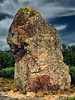
<< Text Pages >> Menhir du Flat - Standing Stone (Menhir) in France in Rhone:Loire (42)
Submitted by holger_rix on Sunday, 26 June 2016 Page Views: 1176
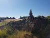
Neolithic and Bronze AgeSite Name: Menhir du FlatCountry: France
NOTE: This site is 15.527 km away from the location you searched for.
Département: Rhone:Loire (42) Type: Standing Stone (Menhir)
Nearest Town: Colombier Nearest Village: Les Fougères
Latitude: 45.336471N Longitude: 4.605730E
Condition:
| 5 | Perfect |
| 4 | Almost Perfect |
| 3 | Reasonable but with some damage |
| 2 | Ruined but still recognisable as an ancient site |
| 1 | Pretty much destroyed, possibly visible as crop marks |
| 0 | No data. |
| -1 | Completely destroyed |
| 5 | Superb |
| 4 | Good |
| 3 | Ordinary |
| 2 | Not Good |
| 1 | Awful |
| 0 | No data. |
| 5 | Can be driven to, probably with disabled access |
| 4 | Short walk on a footpath |
| 3 | Requiring a bit more of a walk |
| 2 | A long walk |
| 1 | In the middle of nowhere, a nightmare to find |
| 0 | No data. |
| 5 | co-ordinates taken by GPS or official recorded co-ordinates |
| 4 | co-ordinates scaled from a detailed map |
| 3 | co-ordinates scaled from a bad map |
| 2 | co-ordinates of the nearest village |
| 1 | co-ordinates of the nearest town |
| 0 | no data |
Be the first person to rate this site - see the 'Contribute!' box in the right hand menu.
Internal Links:
External Links:
Standing Stone (Menhir) in Rhone:Loire (42)
Le Flat, Les Fougères, Colombier, Saint-Étienne, Loire, Auvergne-Rhône-Alpes
Source: T4T35
Information and Pictures:
t4t35.fr
Wikipedia article
Sites mégalithiques de la Loire
You may be viewing yesterday's version of this page. To see the most up to date information please register for a free account.
Do not use the above information on other web sites or publications without permission of the contributor.
Nearby Images from Flickr

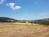
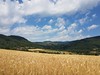
The above images may not be of the site on this page, but were taken nearby. They are loaded from Flickr so please click on them for image credits.
Click here to see more info for this site
Nearby sites
Click here to view sites on an interactive map of the areaKey: Red: member's photo, Blue: 3rd party photo, Yellow: other image, Green: no photo - please go there and take one, Grey: site destroyed
Download sites to:
KML (Google Earth)
GPX (GPS waypoints)
CSV (Garmin/Navman)
CSV (Excel)
To unlock full downloads you need to sign up as a Contributory Member. Otherwise downloads are limited to 50 sites.
Turn off the page maps and other distractions
Nearby sites listing. In the following links * = Image available
7.0km WSW 250° Saint-Romain-en-Gal Ancient Village or Settlement
12.7km SSW 204° Roches à Cupules de Peyremalle Rock Art
22.8km WNW 287° Dolmen de Chambon-Feugerolles Burial Chamber or Dolmen
27.9km SE 134° Les Roches qui dansent* Natural Stone / Erratic / Other Natural Feature
29.4km WNW 287° Dolmen des Echandes Burial Chamber or Dolmen
32.8km NNW 347° Dolmen de Vaudragon Burial Chamber or Dolmen
34.3km ESE 105° Palais idéal* Modern Stone Circle etc
35.9km SSE 168° Dolmen de Chabot Burial Chamber or Dolmen
36.4km SW 227° Croix-Menhir de Mendigoules* Standing Stone (Menhir)
39.3km WSW 246° Roche à Cupules des Barris Standing Stones
40.1km SSW 205° Lichessol Statue-menhir Standing Stone (Menhir)
41.0km SW 223° Dolmen de Vacheresses Burial Chamber or Dolmen
41.4km N 2° Dolmen dit la Roche aux Fées Burial Chamber or Dolmen
41.6km SW 230° Saint-Jeurés Menhir* Standing Stone (Menhir)
42.3km WNW 288° Dolmen de Roche-Cubertelle* Burial Chamber or Dolmen
43.8km WNW 284° Saint-Bonnet-Le-Chateau Roches* Not Known (by us)
44.0km SW 217° Dolmen des Pennes* Burial Chamber or Dolmen
44.2km N 360° Oppidum du Châtelar Ancient Village or Settlement
45.4km SW 226° Chièze Menhir* Standing Stone (Menhir)
49.7km WSW 255° Artites Dolmen Burial Chamber or Dolmen
49.8km SW 232° Pierre à Cupules de Monedeyre Rock Art
49.9km NNE 19° Lugdunum* Ancient Village or Settlement
50.0km NNE 19° Musée Gallo-Romain* Museum
50.5km ENE 67° Ciste de Meyrieu-les-Étangs Burial Chamber or Dolmen
51.9km NNE 20° Gros Caillou (Lyon)* Natural Stone / Erratic / Other Natural Feature
View more nearby sites and additional images


 We would like to know more about this location. Please feel free to add a brief description and any relevant information in your own language.
 Wir möchten mehr über diese Stätte erfahren. Bitte zögern Sie nicht, eine kurze Beschreibung und relevante Informationen in Deutsch hinzuzufügen.
 Nous aimerions en savoir encore un peu sur les lieux. S'il vous plaît n'hesitez pas à ajouter une courte description et tous les renseignements pertinents dans votre propre langue.
 Quisieramos informarnos un poco más de las lugares. No dude en añadir una breve descripción y otros datos relevantes en su propio idioma.