

<< Text Pages >> Mas Cadenet dolmen - Passage Grave in France in Provence:Bouches-du-Rhône (13)
Submitted by thecaptain on Wednesday, 25 April 2007 Page Views: 2735
Neolithic and Bronze AgeSite Name: Mas Cadenet dolmenCountry: France
NOTE: This site is 2.5 km away from the location you searched for.
Département: Provence:Bouches-du-Rhône (13) Type: Passage Grave
Nearest Town: Arles Nearest Village: Fontvieille
Latitude: 43.706000N Longitude: 4.702000E
Condition:
| 5 | Perfect |
| 4 | Almost Perfect |
| 3 | Reasonable but with some damage |
| 2 | Ruined but still recognisable as an ancient site |
| 1 | Pretty much destroyed, possibly visible as crop marks |
| 0 | No data. |
| -1 | Completely destroyed |
| 5 | Superb |
| 4 | Good |
| 3 | Ordinary |
| 2 | Not Good |
| 1 | Awful |
| 0 | No data. |
| 5 | Can be driven to, probably with disabled access |
| 4 | Short walk on a footpath |
| 3 | Requiring a bit more of a walk |
| 2 | A long walk |
| 1 | In the middle of nowhere, a nightmare to find |
| 0 | No data. |
| 5 | co-ordinates taken by GPS or official recorded co-ordinates |
| 4 | co-ordinates scaled from a detailed map |
| 3 | co-ordinates scaled from a bad map |
| 2 | co-ordinates of the nearest village |
| 1 | co-ordinates of the nearest town |
| 0 | no data |
Internal Links:
External Links:
I have visited· I would like to visit
TheCaptain couldn't find on 22nd Sep 2005 I could not find this dolmen or hypogae, there are lots of private property signs all around, although not the big fences this time.
IMPORTANT NOTE: Site believed to be near this position
You may be viewing yesterday's version of this page. To see the most up to date information please register for a free account.
Do not use the above information on other web sites or publications without permission of the contributor.
Nearby Images from Flickr
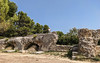
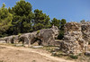
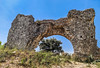
The above images may not be of the site on this page, but were taken nearby. They are loaded from Flickr so please click on them for image credits.
Click here to see more info for this site
Nearby sites
Click here to view sites on an interactive map of the areaKey: Red: member's photo, Blue: 3rd party photo, Yellow: other image, Green: no photo - please go there and take one, Grey: site destroyed
Download sites to:
KML (Google Earth)
GPX (GPS waypoints)
CSV (Garmin/Navman)
CSV (Excel)
To unlock full downloads you need to sign up as a Contributory Member. Otherwise downloads are limited to 50 sites.
Turn off the page maps and other distractions
Nearby sites listing. In the following links * = Image available
1.0km SE 130° Dolmen du Mas d'Agard Burial Chamber or Dolmen
1.4km WNW 284° Hypogée de Bonnias Passage Grave
1.6km WNW 289° Grotte de la Source Passage Grave
1.6km ESE 102° Barbegal Mill and Aquaduct* Ancient Mine, Quarry or other Industry
1.9km W 272° Menhir de Saint-Contignarde Standing Stone (Menhir)
2.0km W 272° Dolmen de Saint-Contignarde Passage Grave
2.1km W 280° Hypogee du Castelet* Passage Grave
2.2km WSW 253° La Grotte des Fées de Cordes* Passage Grave
2.3km WSW 256° Epée de Roland Menhir Standing Stone (Menhir)
2.4km WSW 252° Arnaud Hypogee Long Barrow
2.5km E 100° Dolmen de la Mérindole Burial Chamber or Dolmen
8.5km ENE 61° La grotte de Costapera Cave or Rock Shelter
8.7km ENE 60° Les Baux* Ancient Village or Settlement
9.4km N 5° Menhir Mourgue Standing Stone (Menhir)
11.5km SE 131° Mas deu Moulin Artificial Mound
11.6km SE 131° Baume de Trou Cave or Rock Shelter
13.0km NE 54° Glanum* Ancient Village or Settlement
13.3km NE 49° Grotte Baldouin Cave or Rock Shelter
13.3km NE 49° Grotte Romanin 1 Cave or Rock Shelter
13.4km NE 48° Grotte Romanin 2 Cave or Rock Shelter
13.4km NE 48° Grotte des Chats Cave or Rock Shelter
14.3km E 87° Oppidum des Caisses* Ancient Village or Settlement
19.6km E 90° Roucas de l'Eure Burial Chamber or Dolmen
20.8km ENE 72° Tombe Meynier Cave or Rock Shelter
23.0km NNE 32° Les Tours Cave or Rock Shelter
View more nearby sites and additional images


 We would like to know more about this location. Please feel free to add a brief description and any relevant information in your own language.
 Wir möchten mehr über diese Stätte erfahren. Bitte zögern Sie nicht, eine kurze Beschreibung und relevante Informationen in Deutsch hinzuzufügen.
 Nous aimerions en savoir encore un peu sur les lieux. S'il vous plaît n'hesitez pas à ajouter une courte description et tous les renseignements pertinents dans votre propre langue.
 Quisieramos informarnos un poco más de las lugares. No dude en añadir una breve descripción y otros datos relevantes en su propio idioma.