<< Our Photo Pages >> Arsameia - Ancient Village or Settlement in Turkey
Submitted by davidmorgan on Thursday, 01 December 2011 Page Views: 7531
Multi-periodSite Name: ArsameiaCountry: Turkey
NOTE: This site is 7.504 km away from the location you searched for.
Type: Ancient Village or Settlement
Nearest Town: Kahta
Latitude: 37.937125N Longitude: 38.652721E
Condition:
| 5 | Perfect |
| 4 | Almost Perfect |
| 3 | Reasonable but with some damage |
| 2 | Ruined but still recognisable as an ancient site |
| 1 | Pretty much destroyed, possibly visible as crop marks |
| 0 | No data. |
| -1 | Completely destroyed |
| 5 | Superb |
| 4 | Good |
| 3 | Ordinary |
| 2 | Not Good |
| 1 | Awful |
| 0 | No data. |
| 5 | Can be driven to, probably with disabled access |
| 4 | Short walk on a footpath |
| 3 | Requiring a bit more of a walk |
| 2 | A long walk |
| 1 | In the middle of nowhere, a nightmare to find |
| 0 | No data. |
| 5 | co-ordinates taken by GPS or official recorded co-ordinates |
| 4 | co-ordinates scaled from a detailed map |
| 3 | co-ordinates scaled from a bad map |
| 2 | co-ordinates of the nearest village |
| 1 | co-ordinates of the nearest town |
| 0 | no data |
Internal Links:
External Links:
I have visited· I would like to visit
Jansold visited on 23rd Sep 2011 - their rating: Cond: 3 Amb: 4 Access: 4
PAB h_fenton davidmorgan have visited here

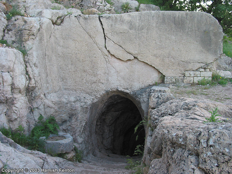
Most of the way down the tunnel there are steps although in places these have been completely worn away. At times water flows down the floor of the tunnel carrying any debris with it, in the top photo you can see the floor of the tunnel is wet.
The lower photo shows what is currently the end of the tunnel, in the 1950s the tunnel was excavated, I'm not too sure whether they got right to the bottom but at the present time the bottom of the tunnel is choked with all the debris that gets washed down with the water in the tunnel - so the debris consists of rock fragments, soil, ancient pottery, chocolate wrappers and plastic bottles.
If you do visit this site and are thinking about going down the tunnel, beyond about 50metres the tunnel gets steeper (and lower - so watch your head!), in places there are no steps, it gets muddy, it can get very slippery - where there are no steps there is just a worn smooth steep rock slope instead.
On my decent I slipped a couple of times and on the way back up I went most of the way on all fours, in some places I was taking two steps forwards then sliding one step backwards. so all in all if you descend this tunnel you are exposing yourself to a certain amount of danger.
I would suggest you take a torch, it is dark down there.
12 May 2003
You may be viewing yesterday's version of this page. To see the most up to date information please register for a free account.


Do not use the above information on other web sites or publications without permission of the contributor.
Click here to see more info for this site
Nearby sites
Click here to view sites on an interactive map of the areaKey: Red: member's photo, Blue: 3rd party photo, Yellow: other image, Green: no photo - please go there and take one, Grey: site destroyed
Download sites to:
KML (Google Earth)
GPX (GPS waypoints)
CSV (Garmin/Navman)
CSV (Excel)
To unlock full downloads you need to sign up as a Contributory Member. Otherwise downloads are limited to 50 sites.
Turn off the page maps and other distractions
Nearby sites listing. In the following links * = Image available
3.9km W 262° Cendere Bridge* Ancient Trackway
9.1km ENE 58° Nemrut Dag* Artificial Mound
12.6km SSW 209° Karakus Tumulus* Artificial Mound
18.9km SW 225° Kilisik Statue Sculptured Stone
39.1km S 183° Nevali Cori Ancient Temple
43.7km S 190° Gritille Ancient Village or Settlement
44.0km SSW 192° Sürük Mevkii Ancient Village or Settlement
51.3km S 178° Titris Höyük* Ancient Village or Settlement
54.0km N 9° Cafer Höyük Ancient Village or Settlement
55.6km NNW 333° Arslantepe* Ancient Village or Settlement
60.1km SW 218° Girik Tepe Ancient Village or Settlement
75.8km WSW 238° Levzin Höyuk Ancient Village or Settlement
82.9km SSE 163° Göbekli Tepe* Ancient Temple
84.0km S 186° Ayanlar Höyük Ancient Village or Settlement
84.9km SE 139° Başbük Ancient Village or Settlement
85.0km SE 139° Tasli Tepe Ancient Village or Settlement
88.4km S 172° Yeni Mahalle Ancient Village or Settlement
91.9km S 182° Sayburç* Ancient Village or Settlement
92.5km S 169° Gürcütepe Ancient Village or Settlement
93.4km ENE 70° Gri Havsarik Ancient Village or Settlement
93.8km SE 146° Kurt Tepesi Ancient Village or Settlement
94.3km ENE 71° Kikan Harabesi Ancient Village or Settlement
94.3km NNE 30° Elazig Museum Museum
95.8km S 172° Hamzan Tepe Ancient Village or Settlement
97.6km S 182° Çakmaktepe Ancient Village or Settlement
View more nearby sites and additional images


 We would like to know more about this location. Please feel free to add a brief description and any relevant information in your own language.
 Wir möchten mehr über diese Stätte erfahren. Bitte zögern Sie nicht, eine kurze Beschreibung und relevante Informationen in Deutsch hinzuzufügen.
 Nous aimerions en savoir encore un peu sur les lieux. S'il vous plaît n'hesitez pas à ajouter une courte description et tous les renseignements pertinents dans votre propre langue.
 Quisieramos informarnos un poco más de las lugares. No dude en añadir una breve descripción y otros datos relevantes en su propio idioma.