

<< Our Photo Pages >> Wadi Rum Petroglyphs - Rock Art in Jordan
Submitted by mrcrow on Thursday, 21 March 2024 Page Views: 42
Rock ArtSite Name: Wadi Rum PetroglyphsCountry: Jordan
NOTE: This site is 17.508 km away from the location you searched for.
Type: Rock Art
Latitude: 29.759200N Longitude: 35.496300E
Condition:
| 5 | Perfect |
| 4 | Almost Perfect |
| 3 | Reasonable but with some damage |
| 2 | Ruined but still recognisable as an ancient site |
| 1 | Pretty much destroyed, possibly visible as crop marks |
| 0 | No data. |
| -1 | Completely destroyed |
| 5 | Superb |
| 4 | Good |
| 3 | Ordinary |
| 2 | Not Good |
| 1 | Awful |
| 0 | No data. |
| 5 | Can be driven to, probably with disabled access |
| 4 | Short walk on a footpath |
| 3 | Requiring a bit more of a walk |
| 2 | A long walk |
| 1 | In the middle of nowhere, a nightmare to find |
| 0 | No data. |
| 5 | co-ordinates taken by GPS or official recorded co-ordinates |
| 4 | co-ordinates scaled from a detailed map |
| 3 | co-ordinates scaled from a bad map |
| 2 | co-ordinates of the nearest village |
| 1 | co-ordinates of the nearest town |
| 0 | no data |
Internal Links:
External Links:
I have visited· I would like to visit
mrcrow has visited here
")
At one site in Wadi Rum, under a rock overhang, are several petroglyphs and Safaitic writings. The petroglyphs are about 30 feet up the rock wall, above the desert floor. The rock wall can be scrambled up to get to a narrow shelf just below the the petroglyphs. The petroglyphs depict camels, oryx, lions, and ostriches. There are some modern graffiti alongside the Safaitic writings, which are obvious due to the coloration. The graffiti appears to be modern Arabic that has been scratched upon.
Wikipedia - Safaitic
The Safaitic scripts: palaeography of an ancient nomadic writing culture, Della Puppa, C. (2022)
You may be viewing yesterday's version of this page. To see the most up to date information please register for a free account.
")
")
Do not use the above information on other web sites or publications without permission of the contributor.
Nearby Images from Flickr


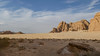


The above images may not be of the site on this page, but were taken nearby. They are loaded from Flickr so please click on them for image credits.
Click here to see more info for this site
Nearby sites
Click here to view sites on an interactive map of the areaKey: Red: member's photo, Blue: 3rd party photo, Yellow: other image, Green: no photo - please go there and take one, Grey: site destroyed
Download sites to:
KML (Google Earth)
GPX (GPS waypoints)
CSV (Garmin/Navman)
CSV (Excel)
To unlock full downloads you need to sign up as a Contributory Member. Otherwise downloads are limited to 50 sites.
Turn off the page maps and other distractions
Nearby sites listing. In the following links * = Image available
22.9km SSW 198° Wadi Rum Ritual Structures* Ancient Temple
23.3km SSW 198° Wadi Rum Chambered Tomb* Chambered Tomb
23.6km SSW 199° Wadi Rum Massebah (1)* Cairn
24.4km SSW 197° Wadi Rum Massebah (2)* Burial Chamber or Dolmen
24.7km SSW 200° Wadi Rum Masseboth* Standing Stones
25.8km NNW 326° Humeima* Ancient Village or Settlement
27.6km SSW 191° Wadi Kahkashea* Carving
27.6km SSW 191° Jabel Kashkash Statue* Sculptured Stone
31.8km N 358° Big Circle J8 Misc. Earthwork
37.1km NNE 12° M'aan district* Carving
37.2km SSW 205° Wadi Rum Engravings* Carving
37.6km SSW 212° Wadi Dhaika Engravings* Carving
44.3km SSW 199° Khirbet Rizqeh* Standing Stone (Menhir)
48.1km WNW 289° Zugan Pass Cult Site* Ancient Temple
49.0km W 277° Ancient Copper Strip-mine north of Mt. Michrot* Ancient Mine, Quarry or other Industry
49.1km W 274° Sasgon valley* Standing Stones
49.4km WNW 301° Grofit hights* Ancient Temple
49.6km WNW 290° S' of Shacharut pass Open Air Sanctuaries* Ancient Temple
49.6km NW 306° lower wadi Qtura* Ancient Village or Settlement
49.9km W 276° Mount. Michrot* Ancient Temple
49.9km WNW 294° Southern Itro pass * Stone Row / Alignment
50.2km NW 314° South to Kibuts Yahel* Ancient Village or Settlement
50.2km W 276° N' W' Timna valley ancient copper industry* Ancient Mine, Quarry or other Industry
50.4km WNW 296° Itro pass Roded Figurines* Ancient Temple
50.4km WNW 298° Top Itro pass 7 Matseboth* Standing Stone (Menhir)
View more nearby sites and additional images


 We would like to know more about this location. Please feel free to add a brief description and any relevant information in your own language.
 Wir möchten mehr über diese Stätte erfahren. Bitte zögern Sie nicht, eine kurze Beschreibung und relevante Informationen in Deutsch hinzuzufügen.
 Nous aimerions en savoir encore un peu sur les lieux. S'il vous plaît n'hesitez pas à ajouter une courte description et tous les renseignements pertinents dans votre propre langue.
 Quisieramos informarnos un poco más de las lugares. No dude en añadir una breve descripción y otros datos relevantes en su propio idioma.