<< Our Photo Pages >> Hdhabat Chajaj Nawamis - Burial Chamber or Dolmen in Egypt in Sinai
Submitted by Motist on Monday, 29 May 2006 Page Views: 6883
Neolithic and Bronze AgeSite Name: Hdhabat Chajaj Nawamis Alternative Name: Hdhabat Chajaj NawamisCountry: Egypt
NOTE: This site is 36.543 km away from the location you searched for.
Region: Sinai Type: Burial Chamber or Dolmen
Nearest Town: Hdhabat Chajaj Nearest Village: Sharm El Shaykh
Latitude: 28.858702N Longitude: 34.376503E
Condition:
| 5 | Perfect |
| 4 | Almost Perfect |
| 3 | Reasonable but with some damage |
| 2 | Ruined but still recognisable as an ancient site |
| 1 | Pretty much destroyed, possibly visible as crop marks |
| 0 | No data. |
| -1 | Completely destroyed |
| 5 | Superb |
| 4 | Good |
| 3 | Ordinary |
| 2 | Not Good |
| 1 | Awful |
| 0 | No data. |
| 5 | Can be driven to, probably with disabled access |
| 4 | Short walk on a footpath |
| 3 | Requiring a bit more of a walk |
| 2 | A long walk |
| 1 | In the middle of nowhere, a nightmare to find |
| 0 | No data. |
| 5 | co-ordinates taken by GPS or official recorded co-ordinates |
| 4 | co-ordinates scaled from a detailed map |
| 3 | co-ordinates scaled from a bad map |
| 2 | co-ordinates of the nearest village |
| 1 | co-ordinates of the nearest town |
| 0 | no data |
Be the first person to rate this site - see the 'Contribute!' box in the right hand menu.
Internal Links:
External Links:
I have visited· I would like to visit
AnnetFransen visited on 2nd Jan 2021 - their rating: Cond: 4 Amb: 5 Access: 4
AnnetFransen visited on 2nd Jan 2021 - their rating: Cond: 4 Amb: 5 Access: 4
Average ratings for this site from all visit loggers: Condition: 4 Ambience: 5 Access: 4
")
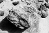
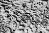
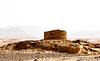
In central south Sinai there old tombs from the 5th millennium BCE. The Beduin call them NAWAMIS (plu.) and Namus (sing.) by. The facing West door is built from local sandstone. According to prof. O. Bar-Yosef pre-dinastic people belived that the soul departed westward to the under world. All the tombs in the main part of Egypt are on the western of the Nile. The Nawamis in Southern Sinai are built from local stones, in this area, sandstone, but places like W. Zalaqa are built from local limestone. The construction of the Nawamis is interesting as Namus in Arabic is moskito. The local legend is that when the Israelites were dweling in the desert they encountered a plague of moskitos, so they constracted Nawamis to hide.
Note: Coordinates converted from old Israel datum: 088750E, 808520N.
You may be viewing yesterday's version of this page. To see the most up to date information please register for a free account.
")
Do not use the above information on other web sites or publications without permission of the contributor.
Nearby Images from Flickr
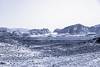
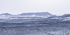
The above images may not be of the site on this page, but were taken nearby. They are loaded from Flickr so please click on them for image credits.
Click here to see more info for this site
Nearby sites
Click here to view sites on an interactive map of the areaKey: Red: member's photo, Blue: 3rd party photo, Yellow: other image, Green: no photo - please go there and take one, Grey: site destroyed
Download sites to:
KML (Google Earth)
GPX (GPS waypoints)
CSV (Garmin/Navman)
CSV (Excel)
To unlock full downloads you need to sign up as a Contributory Member. Otherwise downloads are limited to 50 sites.
Turn off the page maps and other distractions
Nearby sites listing. In the following links * = Image available
28.6km WSW 253° Zaranich Ras Al Zalaka rock painting* Cave or Rock Shelter
29.3km WSW 252° Moiat Dhaba'iya Masseboth* Standing Stones
31.6km WSW 254° Al trefiya Nawamis* Portal Tomb
53.5km WSW 246° Aqrat Safna nabatean village in Sinai Ancient Village or Settlement
69.3km SW 219° Mount Umm Shomar Predator Trap* Ancient Mine, Quarry or other Industry
84.9km NE 34° Wadi Tweiba* Rock Art
91.4km WNW 283° Serabit el-Khadem Temple of Hathor* Ancient Temple
91.8km NE 34° Ramat Yotam 'roded' type site* Ancient Temple
93.6km NNE 15° Gebel Khashm el Tarif* Ancient Temple
95.1km NNE 31° Netafim Neolithic sanctuary* Ancient Temple
96.2km NNE 31° North of Netafim spring* Ancient Temple
97.3km NNE 32° Roded cult sites* Ancient Temple
97.3km NNE 33° Wadi Tawahin* Ancient Mine, Quarry or other Industry
97.8km W 273° Wadi Maghareh* Ancient Mine, Quarry or other Industry
97.9km NE 34° Shahmon Desert Kite* Misc. Earthwork
98.0km NNE 32° Wadi Roded Open Air Sanctuaries* Ancient Temple
98.9km NNE 32° Yedidyah pass Roded type cult site* Ancient Village or Settlement
100.5km NE 34° Arround Shchoret hills* Ancient Village or Settlement
100.5km NNE 34° Shehoret Hills Desert Kite* Misc. Earthwork
100.6km NNE 33° Shchoret habitation site* Ancient Village or Settlement
100.9km NNE 29° Mount Uzia West Predators Trap* Misc. Earthwork
100.9km NE 34° Shchoret hills Open Air Mosque* Ancient Temple
103.8km NNE 31° Upper Wadi Racham Camp* Standing Stones
104.3km NNE 32° Mt. 'Amram Tumulus* Burial Chamber or Dolmen
104.9km NNE 29° North of Wadi Shani Masseboth* Standing Stones
View more nearby sites and additional images


 We would like to know more about this location. Please feel free to add a brief description and any relevant information in your own language.
 Wir möchten mehr über diese Stätte erfahren. Bitte zögern Sie nicht, eine kurze Beschreibung und relevante Informationen in Deutsch hinzuzufügen.
 Nous aimerions en savoir encore un peu sur les lieux. S'il vous plaît n'hesitez pas à ajouter une courte description et tous les renseignements pertinents dans votre propre langue.
 Quisieramos informarnos un poco más de las lugares. No dude en añadir una breve descripción y otros datos relevantes en su propio idioma.