

<< Text Pages >> Ukula Rock Paintings - Rock Art in Kenya
Submitted by KaiHofmann on Thursday, 29 January 2015 Page Views: 2225
Rock ArtSite Name: Ukula Rock PaintingsCountry: Kenya
NOTE: This site is 180.45 km away from the location you searched for.
Type: Rock Art
Nearest Village: Ukula
Latitude: 0.458074S Longitude: 33.995495E
Condition:
| 5 | Perfect |
| 4 | Almost Perfect |
| 3 | Reasonable but with some damage |
| 2 | Ruined but still recognisable as an ancient site |
| 1 | Pretty much destroyed, possibly visible as crop marks |
| 0 | No data. |
| -1 | Completely destroyed |
| 5 | Superb |
| 4 | Good |
| 3 | Ordinary |
| 2 | Not Good |
| 1 | Awful |
| 0 | No data. |
| 5 | Can be driven to, probably with disabled access |
| 4 | Short walk on a footpath |
| 3 | Requiring a bit more of a walk |
| 2 | A long walk |
| 1 | In the middle of nowhere, a nightmare to find |
| 0 | No data. |
| 5 | co-ordinates taken by GPS or official recorded co-ordinates |
| 4 | co-ordinates scaled from a detailed map |
| 3 | co-ordinates scaled from a bad map |
| 2 | co-ordinates of the nearest village |
| 1 | co-ordinates of the nearest town |
| 0 | no data |
Internal Links:
External Links:
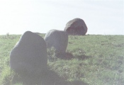
Rock paintings on Mfangano island at Lake Victoria in Kenya.
The paintings are located in a small cave close to Ukula and are showing up to 50cm large spirals and other geometric paintings in reddish colour.
You may be viewing yesterday's version of this page. To see the most up to date information please register for a free account.
Do not use the above information on other web sites or publications without permission of the contributor.
Click here to see more info for this site
Nearby sites
Click here to view sites on an interactive map of the areaKey: Red: member's photo, Blue: 3rd party photo, Yellow: other image, Green: no photo - please go there and take one, Grey: site destroyed
Download sites to:
KML (Google Earth)
GPX (GPS waypoints)
CSV (Garmin/Navman)
CSV (Excel)
To unlock full downloads you need to sign up as a Contributory Member. Otherwise downloads are limited to 50 sites.
Turn off the page maps and other distractions
Nearby sites listing. In the following links * = Image available
179.6km NNE 31° Orchard Cave, Kenya* Cave or Rock Shelter
182.0km N 3° Kakoro Rock art Rock Art
215.8km N 356° Nyero Rockpaintings Rock Art
235.4km E 85° Hyrax Hill Ancient Village or Settlement
266.4km SSE 161° Gong Rock* Rock Art
363.6km NE 40° Namoratunga Rock Engravings Rock Art
395.4km NE 37° Lokori Stone Pillars Standing Stone (Menhir)
396.5km ENE 79° Lewa Rock Gongs Rock Art
440.9km NNE 31° Lothagam Pillar site Standing Stones
476.0km NNE 25° Kalokol stone pillars* Standing Stones
479.9km WNW 293° Matupi Cave Cave or Rock Shelter
667.6km SSE 163° Dodoma Stones* Natural Stone / Erratic / Other Natural Feature
842.0km SSE 168° Isimila* Ancient Village or Settlement
886.4km NNE 32° Tutu Fela* Sculptured Stone
1113.4km NNE 27° Tiya Stelae Standing Stones
1124.4km SSW 196° Mwela rock paintings Rock Art
1414.2km NNW 337° Dar Kabira settlement* Ancient Village or Settlement
1414.4km NNW 337° Dar Kabira Paintings* Rock Art
1425.2km NNW 338° Tareen basin and cup marks* Carving
1428.2km NNW 338° Warina ancient settlement* Ancient Village or Settlement
1458.1km NNE 14° Gorgora Rock Shelter* Cave or Rock Shelter
1539.0km S 179° Chongoni Rock Art Rock Art
1583.1km NE 45° Laas Gaal* Cave or Rock Shelter
1611.3km SW 217° Nyambwezu Rock Shelter Rock Art
1703.5km NNE 18° Aksum* Ancient Village or Settlement
View more nearby sites and additional images


 We would like to know more about this location. Please feel free to add a brief description and any relevant information in your own language.
 Wir möchten mehr über diese Stätte erfahren. Bitte zögern Sie nicht, eine kurze Beschreibung und relevante Informationen in Deutsch hinzuzufügen.
 Nous aimerions en savoir encore un peu sur les lieux. S'il vous plaît n'hesitez pas à ajouter une courte description et tous les renseignements pertinents dans votre propre langue.
 Quisieramos informarnos un poco más de las lugares. No dude en añadir una breve descripción y otros datos relevantes en su propio idioma.