

<< Text Pages >> Grotte Sépulcrale du Bouillon - Cave or Rock Shelter in France in Picardie:Aisne (02)
Submitted by holger_rix on Monday, 09 May 2016 Page Views: 1459
Natural PlacesSite Name: Grotte Sépulcrale du BouillonCountry: France Département: Picardie:Aisne (02) Type: Cave or Rock Shelter
Nearest Town: Château-Thierry Nearest Village: Vichel-Nanteuil
Latitude: 49.187173N Longitude: 3.272810E
Condition:
| 5 | Perfect |
| 4 | Almost Perfect |
| 3 | Reasonable but with some damage |
| 2 | Ruined but still recognisable as an ancient site |
| 1 | Pretty much destroyed, possibly visible as crop marks |
| 0 | No data. |
| -1 | Completely destroyed |
| 5 | Superb |
| 4 | Good |
| 3 | Ordinary |
| 2 | Not Good |
| 1 | Awful |
| 0 | No data. |
| 5 | Can be driven to, probably with disabled access |
| 4 | Short walk on a footpath |
| 3 | Requiring a bit more of a walk |
| 2 | A long walk |
| 1 | In the middle of nowhere, a nightmare to find |
| 0 | No data. |
| 5 | co-ordinates taken by GPS or official recorded co-ordinates |
| 4 | co-ordinates scaled from a detailed map |
| 3 | co-ordinates scaled from a bad map |
| 2 | co-ordinates of the nearest village |
| 1 | co-ordinates of the nearest town |
| 0 | no data |
Be the first person to rate this site - see the 'Contribute!' box in the right hand menu.
Internal Links:
External Links:
Cave or Rock Shelter in Picardie:Aisne(02)
Les Guains, Vichel-Nanteuil, Château-Thierry, Aisne, Picardy
Source: Mégalithes dans le monde
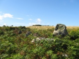
"The "Creutte de Bovillon" (local expression) is 2 meters wide, 2.50 meters deep and 3 m high. His very regular quadrangular reflects an intentional work (more like that of Orrouy as burial caves of the Marne, much more elaborate). Two hundred bodies were piled about 80 cm deep, head leaning against the wall, feet toward the center, about seven or eight rows. A flat stone was arranged under each head. Funerary offerings were placed on the skeletons and in the upper part of the ossuary"
You may be viewing yesterday's version of this page. To see the most up to date information please register for a free account.
Do not use the above information on other web sites or publications without permission of the contributor.
Nearby Images from Flickr

The above images may not be of the site on this page, but were taken nearby. They are loaded from Flickr so please click on them for image credits.
Click here to see more info for this site
Nearby sites
Click here to view sites on an interactive map of the areaKey: Red: member's photo, Blue: 3rd party photo, Yellow: other image, Green: no photo - please go there and take one, Grey: site destroyed
Download sites to:
KML (Google Earth)
GPX (GPS waypoints)
CSV (Garmin/Navman)
CSV (Excel)
To unlock full downloads you need to sign up as a Contributory Member. Otherwise downloads are limited to 50 sites.
Turn off the page maps and other distractions
Nearby sites listing. In the following links * = Image available
11.0km NW 309° Hypogée de la Pierre Fortière* Chambered Tomb
12.0km W 267° Menhir de Précy-à-Mont* Standing Stone (Menhir)
12.6km NNE 27° Dolmen de Taux* Burial Chamber or Dolmen
17.2km ENE 59° Dolmen de la Butte de Housse Burial Chamber or Dolmen
17.8km NW 307° la Pierre Clouise* Polissoir
20.3km SW 220° Allée Couverte du Bois des Marêts Passage Grave
20.4km SW 220° Belleville Hypogee Ancient Village or Settlement
21.3km NE 37° Allée Couverte de la Forte-Terre Burial Chamber or Dolmen
22.0km SW 222° Dolmen du Bois de Belleville Burial Chamber or Dolmen
22.6km E 95° Allée Couverte de Caranda* Burial Chamber or Dolmen
22.6km ENE 61° Banc des Trois-Seigneurs Rock Art
23.9km SE 127° Pierre des Cosaques* Polissoir
25.6km WNW 286° Grotte Sepulcrale du Laris-Goguet Chambered Tomb
26.1km WNW 288° Grotte Sepulcrale de Lari-Baré Cave or Rock Shelter
26.2km NNE 16° Pierre Frite de Crouy Natural Stone / Erratic / Other Natural Feature
27.1km N 3° Dolmen dit la Pierre Laye* Burial Chamber or Dolmen
29.2km NW 320° Cromlech du Parc-aux-Loups Stone Circle
31.2km W 265° Dolmen de Nanteuil-le-Haudouin Burial Chamber or Dolmen
31.3km WNW 285° Dolmen de Séry-Magneval Burial Chamber or Dolmen
31.4km WNW 285° Grotte du Sery-Magneval Cave or Rock Shelter
32.2km W 268° Pierre Glissoire de Péroy-les-Gombries Standing Stone (Menhir)
32.2km SW 228° Germigny-l'Eveque sepulture Passage Grave
32.3km WNW 291° Grotte du Mont-Megre Cave or Rock Shelter
34.8km NW 315° La Pierre Torniche* Burial Chamber or Dolmen
38.3km SW 228° Le Poteau Vert Passage Grave
View more nearby sites and additional images


 We would like to know more about this location. Please feel free to add a brief description and any relevant information in your own language.
 Wir möchten mehr über diese Stätte erfahren. Bitte zögern Sie nicht, eine kurze Beschreibung und relevante Informationen in Deutsch hinzuzufügen.
 Nous aimerions en savoir encore un peu sur les lieux. S'il vous plaît n'hesitez pas à ajouter une courte description et tous les renseignements pertinents dans votre propre langue.
 Quisieramos informarnos un poco más de las lugares. No dude en añadir una breve descripción y otros datos relevantes en su propio idioma.