<< Our Photo Pages >> Turtudui menhir - Standing Stone (Menhir) in Romania
Submitted by mfrincu on Friday, 05 August 2016 Page Views: 1901
Neolithic and Bronze AgeSite Name: Turtudui menhirCountry: Romania
NOTE: This site is 39.159 km away from the location you searched for.
Type: Standing Stone (Menhir)
Nearest Town: Patarlagele Nearest Village: Nucu
Latitude: 45.429329N Longitude: 26.450486E
Condition:
| 5 | Perfect |
| 4 | Almost Perfect |
| 3 | Reasonable but with some damage |
| 2 | Ruined but still recognisable as an ancient site |
| 1 | Pretty much destroyed, possibly visible as crop marks |
| 0 | No data. |
| -1 | Completely destroyed |
| 5 | Superb |
| 4 | Good |
| 3 | Ordinary |
| 2 | Not Good |
| 1 | Awful |
| 0 | No data. |
| 5 | Can be driven to, probably with disabled access |
| 4 | Short walk on a footpath |
| 3 | Requiring a bit more of a walk |
| 2 | A long walk |
| 1 | In the middle of nowhere, a nightmare to find |
| 0 | No data. |
| 5 | co-ordinates taken by GPS or official recorded co-ordinates |
| 4 | co-ordinates scaled from a detailed map |
| 3 | co-ordinates scaled from a bad map |
| 2 | co-ordinates of the nearest village |
| 1 | co-ordinates of the nearest town |
| 0 | no data |
Internal Links:
External Links:
")
On the top of the Turtudui peak in the Buzau mountains we can find the remains of a once standing menhir with some petroglyphs which have yet to be deciphered.
Legend has it that the menhir was initially placed on an horizontal platform which was destroyed in the 80s.
You may be viewing yesterday's version of this page. To see the most up to date information please register for a free account.
")
Do not use the above information on other web sites or publications without permission of the contributor.
Nearby Images from Flickr
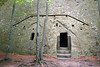
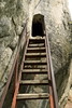
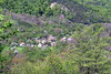


The above images may not be of the site on this page, but were taken nearby. They are loaded from Flickr so please click on them for image credits.
Click here to see more info for this site
Nearby sites
Click here to view sites on an interactive map of the areaKey: Red: member's photo, Blue: 3rd party photo, Yellow: other image, Green: no photo - please go there and take one, Grey: site destroyed
Download sites to:
KML (Google Earth)
GPX (GPS waypoints)
CSV (Garmin/Navman)
CSV (Excel)
To unlock full downloads you need to sign up as a Contributory Member. Otherwise downloads are limited to 50 sites.
Turn off the page maps and other distractions
Nearby sites listing. In the following links * = Image available
1.1km SW 232° Menhir near Fundul Pesterii* Standing Stone (Menhir)
1.1km SW 233° Fundul Pesterii Cave* Rock Art
113.5km S 187° Cernica Neolithic Tombs* Barrow Cemetery
114.4km SSW 194° National Museum of Romanian History Museum
157.9km NNW 336° Gheorgheni Museum Museum
165.7km SE 128° Capidava* Ancient Village or Settlement
168.2km E 100° Telita-Celic Dere* Barrow Cemetery
179.1km NE 50° Upper Trajan's Wall Misc. Earthwork
180.7km NNW 337° Teasc Mountain* Rock Art
189.0km S 172° Sveshtari Thracian Tomb* Chambered Cairn
189.4km SE 141° Tropaeum Traiani* Sculptured Stone
190.8km SE 141° Adamclisi Museum of Antiquities* Museum
191.9km N 359° Grumăzești - Deleni Ancient Village or Settlement
204.6km ESE 117° Istria burial site* Barrow Cemetery
206.9km SSW 212° Crangu Artifical Mounds* Artificial Mound
207.2km ESE 117° Histria Museum of History* Museum
207.4km ESE 117° Histria* Ancient Village or Settlement
208.8km ESE 116° Fertility menhir* Standing Stone (Menhir)
209.2km ESE 110° Argamum* Ancient Village or Settlement
216.6km NNW 335° Gura Haitii Petroglyphs* Rock Art
217.7km WNW 283° Capâlna Dacian citadel Hillfort
223.2km SE 128° Constanta Museum of National History and Archaeology* Museum
230.6km SW 232° Olt Burial Site Round Cairn
233.3km SSE 166° Pliska Mound Artificial Mound
236.4km SSE 167° Pliska Menhirs* Standing Stones
View more nearby sites and additional images


 We would like to know more about this location. Please feel free to add a brief description and any relevant information in your own language.
 Wir möchten mehr über diese Stätte erfahren. Bitte zögern Sie nicht, eine kurze Beschreibung und relevante Informationen in Deutsch hinzuzufügen.
 Nous aimerions en savoir encore un peu sur les lieux. S'il vous plaît n'hesitez pas à ajouter une courte description et tous les renseignements pertinents dans votre propre langue.
 Quisieramos informarnos un poco más de las lugares. No dude en añadir una breve descripción y otros datos relevantes en su propio idioma.