

<< Our Photo Pages >> Lūžų akmuo su dubeniu - Holed Stone in Lithuania
Submitted by Alta-Falisa on Tuesday, 08 March 2016 Page Views: 1337
Neolithic and Bronze AgeSite Name: Lūžų akmuo su dubeniuCountry: Lithuania
NOTE: This site is 11.392 km away from the location you searched for.
Type: Holed Stone
Nearest Town: Kaunas Nearest Village: Zarasai
Latitude: 55.641700N Longitude: 25.845000E
Condition:
| 5 | Perfect |
| 4 | Almost Perfect |
| 3 | Reasonable but with some damage |
| 2 | Ruined but still recognisable as an ancient site |
| 1 | Pretty much destroyed, possibly visible as crop marks |
| 0 | No data. |
| -1 | Completely destroyed |
| 5 | Superb |
| 4 | Good |
| 3 | Ordinary |
| 2 | Not Good |
| 1 | Awful |
| 0 | No data. |
| 5 | Can be driven to, probably with disabled access |
| 4 | Short walk on a footpath |
| 3 | Requiring a bit more of a walk |
| 2 | A long walk |
| 1 | In the middle of nowhere, a nightmare to find |
| 0 | No data. |
| 5 | co-ordinates taken by GPS or official recorded co-ordinates |
| 4 | co-ordinates scaled from a detailed map |
| 3 | co-ordinates scaled from a bad map |
| 2 | co-ordinates of the nearest village |
| 1 | co-ordinates of the nearest town |
| 0 | no data |
Internal Links:
External Links:
")
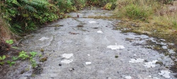
Ritual akmuo su debeniu (stone with a bowl) kept in its original place.
The site was excavated in 1971 and dated 16th – 17th century.
Source : Wikipedia.
Non vidi. While in the region in June 2015, I didn't find it, not even the earth road meant to lead to a farmstead just before the stone. The coordinates might be wrong.
You may be viewing yesterday's version of this page. To see the most up to date information please register for a free account.
")
Do not use the above information on other web sites or publications without permission of the contributor.
Nearby Images from Flickr

The above images may not be of the site on this page, but were taken nearby. They are loaded from Flickr so please click on them for image credits.
Click here to see more info for this site
Nearby sites
Click here to view sites on an interactive map of the areaKey: Red: member's photo, Blue: 3rd party photo, Yellow: other image, Green: no photo - please go there and take one, Grey: site destroyed
Download sites to:
KML (Google Earth)
GPX (GPS waypoints)
CSV (Garmin/Navman)
CSV (Excel)
To unlock full downloads you need to sign up as a Contributory Member. Otherwise downloads are limited to 50 sites.
Turn off the page maps and other distractions
Nearby sites listing. In the following links * = Image available
29.5km SE 124° Vardžiukiemio akmuo* Natural Stone / Erratic / Other Natural Feature
33.9km WSW 237° Zarasų akmuo su dubeniu* Holed Stone
33.9km WSW 237° Kilėviškių akmuo su dubeniu* Holed Stone
52.4km WSW 251° Puntuko akmuo* Natural Stone / Erratic / Other Natural Feature
52.7km SSE 156° Bajorų akmuo* Natural Stone / Erratic / Other Natural Feature
55.3km SSE 157° Šventos akmuo* Natural Stone / Erratic / Other Natural Feature
68.6km NE 34° Nīcgales Lielais Akmens* Natural Stone / Erratic / Other Natural Feature
80.7km WSW 238° Ukmergės piliakalnis* Artificial Mound
84.0km ENE 69° Ūdrīši Akmeņi* Modern Stone Circle etc
85.9km SSW 193° Nemenčinės Bilith* Modern Stone Circle etc
88.3km N 9° Vaiķu Laukakmens* Natural Stone / Erratic / Other Natural Feature
96.9km SW 235° Juozapavos akmuo* Natural Stone / Erratic / Other Natural Feature
107.6km N 354° Stukmaņu Pētera akmens* Natural Stone / Erratic / Other Natural Feature
109.5km SW 222° Zasliai Footprint Stone* Rock Art
109.6km SW 222° Laukagalio akmuo su dubenėliais* Rock Art
112.2km NNW 348° Pastmuižas Velnakmens* Natural Stone / Erratic / Other Natural Feature
118.5km NNW 338° Kraukļu akmens* Natural Stone / Erratic / Other Natural Feature
120.0km NNW 341° Meļķitāru Muldas akmens* Natural Stone / Erratic / Other Natural Feature
126.9km WSW 257° Dotnuvo akmuo* Modern Stone Circle etc
127.8km SSW 195° Marijampolio akmuo* Natural Stone / Erratic / Other Natural Feature
128.2km SW 221° Girelių akmuo* Natural Stone / Erratic / Other Natural Feature
147.3km WSW 248° Karalgirio akmuo* Natural Stone / Erratic / Other Natural Feature
149.5km WSW 237° Santakos parkas* Modern Stone Circle etc
169.4km SSW 200° Mantviliškų akmuo* Natural Stone / Erratic / Other Natural Feature
170.0km N 350° Ūdri (Pūķi) cross stone* Ancient Cross
View more nearby sites and additional images


 We would like to know more about this location. Please feel free to add a brief description and any relevant information in your own language.
 Wir möchten mehr über diese Stätte erfahren. Bitte zögern Sie nicht, eine kurze Beschreibung und relevante Informationen in Deutsch hinzuzufügen.
 Nous aimerions en savoir encore un peu sur les lieux. S'il vous plaît n'hesitez pas à ajouter une courte description et tous les renseignements pertinents dans votre propre langue.
 Quisieramos informarnos un poco más de las lugares. No dude en añadir una breve descripción y otros datos relevantes en su propio idioma.