<< Our Photo Pages >> Zarasų akmuo su dubeniu - Holed Stone in Lithuania
Submitted by Alta-Falisa on Monday, 07 March 2016 Page Views: 1298
Neolithic and Bronze AgeSite Name: Zarasų akmuo su dubeniuCountry: Lithuania
NOTE: This site is 27.941 km away from the location you searched for.
Type: Holed Stone
Nearest Town: Kaunas Nearest Village: Leliūnai
Latitude: 55.475600N Longitude: 25.393200E
Condition:
| 5 | Perfect |
| 4 | Almost Perfect |
| 3 | Reasonable but with some damage |
| 2 | Ruined but still recognisable as an ancient site |
| 1 | Pretty much destroyed, possibly visible as crop marks |
| 0 | No data. |
| -1 | Completely destroyed |
| 5 | Superb |
| 4 | Good |
| 3 | Ordinary |
| 2 | Not Good |
| 1 | Awful |
| 0 | No data. |
| 5 | Can be driven to, probably with disabled access |
| 4 | Short walk on a footpath |
| 3 | Requiring a bit more of a walk |
| 2 | A long walk |
| 1 | In the middle of nowhere, a nightmare to find |
| 0 | No data. |
| 5 | co-ordinates taken by GPS or official recorded co-ordinates |
| 4 | co-ordinates scaled from a detailed map |
| 3 | co-ordinates scaled from a bad map |
| 2 | co-ordinates of the nearest village |
| 1 | co-ordinates of the nearest town |
| 0 | no data |
Internal Links:
External Links:
")
Ritual holed stone found around Zarasai, a town 50 km to the NE towards Daugavpils (Latvia), just before the border.
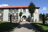
Exhibited on the front garden of the Ceramic Museum of Leliūnai, with two other similar stones.
Please see Kilėviškių akmuo su dubeniu for more information.
As soon as the name of one these two stones is found, we will have to split this page in two (June 2015).
You may be viewing yesterday's version of this page. To see the most up to date information please register for a free account.
")
")
Do not use the above information on other web sites or publications without permission of the contributor.
Nearby Images from Flickr

The above images may not be of the site on this page, but were taken nearby. They are loaded from Flickr so please click on them for image credits.
Click here to see more info for this site
Nearby sites
Click here to view sites on an interactive map of the areaKey: Red: member's photo, Blue: 3rd party photo, Yellow: other image, Green: no photo - please go there and take one, Grey: site destroyed
Download sites to:
KML (Google Earth)
GPX (GPS waypoints)
CSV (Garmin/Navman)
CSV (Excel)
To unlock full downloads you need to sign up as a Contributory Member. Otherwise downloads are limited to 50 sites.
Turn off the page maps and other distractions
Nearby sites listing. In the following links * = Image available
23m SSE 164° Kilėviškių akmuo su dubeniu* Holed Stone
21.0km W 273° Puntuko akmuo* Natural Stone / Erratic / Other Natural Feature
33.9km ENE 57° Lūžų akmuo su dubeniu* Holed Stone
46.8km WSW 238° Ukmergės piliakalnis* Artificial Mound
52.8km E 88° Vardžiukiemio akmuo* Natural Stone / Erratic / Other Natural Feature
58.3km ESE 120° Bajorų akmuo* Natural Stone / Erratic / Other Natural Feature
60.0km ESE 122° Šventos akmuo* Natural Stone / Erratic / Other Natural Feature
63.0km SW 234° Juozapavos akmuo* Natural Stone / Erratic / Other Natural Feature
66.1km S 171° Nemenčinės Bilith* Modern Stone Circle etc
77.3km SW 216° Laukagalio akmuo su dubenėliais* Rock Art
77.4km SW 215° Zasliai Footprint Stone* Rock Art
95.7km W 263° Dotnuvo akmuo* Modern Stone Circle etc
96.2km SW 214° Girelių akmuo* Natural Stone / Erratic / Other Natural Feature
100.6km NE 41° Nīcgales Lielais Akmens* Natural Stone / Erratic / Other Natural Feature
105.0km S 182° Marijampolio akmuo* Natural Stone / Erratic / Other Natural Feature
113.8km NNE 22° Vaiķu Laukakmens* Natural Stone / Erratic / Other Natural Feature
114.3km WSW 251° Karalgirio akmuo* Natural Stone / Erratic / Other Natural Feature
115.7km WSW 237° Santakos parkas* Modern Stone Circle etc
117.4km ENE 65° Ūdrīši Akmeņi* Modern Stone Circle etc
126.7km N 8° Stukmaņu Pētera akmens* Natural Stone / Erratic / Other Natural Feature
128.1km N 2° Pastmuižas Velnakmens* Natural Stone / Erratic / Other Natural Feature
129.3km N 353° Kraukļu akmens* Natural Stone / Erratic / Other Natural Feature
132.3km N 355° Meļķitāru Muldas akmens* Natural Stone / Erratic / Other Natural Feature
144.0km S 191° Mantviliškų akmuo* Natural Stone / Erratic / Other Natural Feature
147.6km SSW 195° Kalesninkų akmuo* Standing Stone (Menhir)
View more nearby sites and additional images


 We would like to know more about this location. Please feel free to add a brief description and any relevant information in your own language.
 Wir möchten mehr über diese Stätte erfahren. Bitte zögern Sie nicht, eine kurze Beschreibung und relevante Informationen in Deutsch hinzuzufügen.
 Nous aimerions en savoir encore un peu sur les lieux. S'il vous plaît n'hesitez pas à ajouter une courte description et tous les renseignements pertinents dans votre propre langue.
 Quisieramos informarnos un poco más de las lugares. No dude en añadir una breve descripción y otros datos relevantes en su propio idioma.