<< Other Photo Pages >> Nenkovo Rock Womb - Cave or Rock Shelter in Bulgaria
Submitted by AlexHunger on Tuesday, 15 April 2008 Page Views: 10409
Natural PlacesSite Name: Nenkovo Rock Womb Alternative Name: Nenkovo Cave Womb, ненково пещеCountry: Bulgaria
NOTE: This site is 17.047 km away from the location you searched for.
Type: Cave or Rock Shelter
Nearest Town: Kurdzhali Nearest Village: Nenkovo
Latitude: 41.733333N Longitude: 25.166667E
Condition:
| 5 | Perfect |
| 4 | Almost Perfect |
| 3 | Reasonable but with some damage |
| 2 | Ruined but still recognisable as an ancient site |
| 1 | Pretty much destroyed, possibly visible as crop marks |
| 0 | No data. |
| -1 | Completely destroyed |
| 5 | Superb |
| 4 | Good |
| 3 | Ordinary |
| 2 | Not Good |
| 1 | Awful |
| 0 | No data. |
| 5 | Can be driven to, probably with disabled access |
| 4 | Short walk on a footpath |
| 3 | Requiring a bit more of a walk |
| 2 | A long walk |
| 1 | In the middle of nowhere, a nightmare to find |
| 0 | No data. |
| 5 | co-ordinates taken by GPS or official recorded co-ordinates |
| 4 | co-ordinates scaled from a detailed map |
| 3 | co-ordinates scaled from a bad map |
| 2 | co-ordinates of the nearest village |
| 1 | co-ordinates of the nearest town |
| 0 | no data |
Internal Links:
External Links:
I have visited· I would like to visit
eirrac5 would like to visit
")
A vagina shaped ritual cave in the mountain above the Borovitsa Chalet, some 14 miles from Kurdzali.
Natural cave originally 15 Meters deep then lengthened to 20 Meters deep.
At noon, the sun seeps into the cave through an opening in the ceiling and projects the representation of a phallus onto the floor which progressively grows longer, reaching out to the womb altar. In January and February, when the sun is at the lowest on the horizon, the phallus becomes long enough to reach the altar and symbolically fertilises the womb.
The site was apparently used for Bacchic rituals. Even now, once a year, young unmarried men and women gather in the local caves to take part in the sacrament of conception.
You may be viewing yesterday's version of this page. To see the most up to date information please register for a free account.
")
Do not use the above information on other web sites or publications without permission of the contributor.
Nearby Images from Flickr
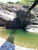
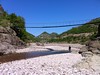
The above images may not be of the site on this page, but were taken nearby. They are loaded from Flickr so please click on them for image credits.
Click here to see more info for this site
Nearby sites
Click here to view sites on an interactive map of the areaKey: Red: member's photo, Blue: 3rd party photo, Yellow: other image, Green: no photo - please go there and take one, Grey: site destroyed
Download sites to:
KML (Google Earth)
GPX (GPS waypoints)
CSV (Garmin/Navman)
CSV (Excel)
To unlock full downloads you need to sign up as a Contributory Member. Otherwise downloads are limited to 50 sites.
Turn off the page maps and other distractions
Nearby sites listing. In the following links * = Image available
20.8km NW 308° Belintash Ancient Temple
24.6km E 95° Perperikon* Ancient Temple
25.4km ESE 103° Perperikon Tombs Rock Cut Tomb
33.9km SSE 158° Ovchevo Rock Cut Tomb Rock Cut Tomb
34.0km ESE 121° Harman Kaya Cave or Rock Shelter
38.0km SE 124° Tatul Thracian Temple* Ancient Temple
44.3km ESE 104° Pchelari Rock Cut Tomb Rock Cut Tomb
53.9km E 96° Dolni Glavanak Stone Circle* Stone Circle
57.4km NW 323° Eumolpias Ancient Village or Settlement
58.1km NW 323° Plovdiv Archaelogical Museum Museum
60.2km ENE 73° Ostur kamuk Dolmen Burial Chamber or Dolmen
66.7km SE 130° Chernichevo Dolmen Burial Chamber or Dolmen
71.2km ESE 113° Zhelezino Dolmen* Chambered Tomb
73.3km N 356° The Brothers Megalith* Standing Stones
75.4km ENE 66° Chuchul Kamak Standing Stone (Menhir)
77.4km ESE 114° Plevun dolmen Chambered Tomb
77.6km E 90° Mezek Thracian tomb Chambered Tomb
80.9km ESE 103° Oryahovo Dolmen* Chambered Tomb
80.9km ENE 73° Mound near Izvorovo* Round Barrow(s)
83.8km ENE 77° Eshmedzhika Dolmen Burial Chamber or Dolmen
85.3km ESE 123° Dolmen Roussa 3* Burial Chamber or Dolmen
85.3km ESE 123° Roussa Dolmen* Burial Chamber or Dolmen
85.4km NNE 25° Stara Zagora Neolithic dwellings* Ancient Village or Settlement
86.2km SE 124° Dolmen Roussa* Burial Chamber or Dolmen
88.8km NNW 332° Staro Zhelezare Stone Circle
View more nearby sites and additional images


 We would like to know more about this location. Please feel free to add a brief description and any relevant information in your own language.
 Wir möchten mehr über diese Stätte erfahren. Bitte zögern Sie nicht, eine kurze Beschreibung und relevante Informationen in Deutsch hinzuzufügen.
 Nous aimerions en savoir encore un peu sur les lieux. S'il vous plaît n'hesitez pas à ajouter une courte description et tous les renseignements pertinents dans votre propre langue.
 Quisieramos informarnos un poco más de las lugares. No dude en añadir una breve descripción y otros datos relevantes en su propio idioma.