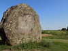
<< Our Photo Pages >> Kalesninkų akmuo - Standing Stone (Menhir) in Lithuania
Submitted by Alta-Falisa on Monday, 21 September 2015 Page Views: 1582
Neolithic and Bronze AgeSite Name: Kalesninkų akmuoCountry: Lithuania
NOTE: This site is 17.142 km away from the location you searched for.
Type: Standing Stone (Menhir)
Nearest Town: Vilnius Nearest Village: Kalesninkai
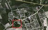
Latitude: 54.192270N Longitude: 24.802050E
Condition:
| 5 | Perfect |
| 4 | Almost Perfect |
| 3 | Reasonable but with some damage |
| 2 | Ruined but still recognisable as an ancient site |
| 1 | Pretty much destroyed, possibly visible as crop marks |
| 0 | No data. |
| -1 | Completely destroyed |
| 5 | Superb |
| 4 | Good |
| 3 | Ordinary |
| 2 | Not Good |
| 1 | Awful |
| 0 | No data. |
| 5 | Can be driven to, probably with disabled access |
| 4 | Short walk on a footpath |
| 3 | Requiring a bit more of a walk |
| 2 | A long walk |
| 1 | In the middle of nowhere, a nightmare to find |
| 0 | No data. |
| 5 | co-ordinates taken by GPS or official recorded co-ordinates |
| 4 | co-ordinates scaled from a detailed map |
| 3 | co-ordinates scaled from a bad map |
| 2 | co-ordinates of the nearest village |
| 1 | co-ordinates of the nearest town |
| 0 | no data |
Internal Links:
External Links:
")
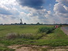
Being at the border between two regions (Varėna district, Alytus county to the West ; Šalčininkai district, Vilnius county to the East) -- or the border having been fixed to take advantage of that traditional landmark --, it used to bear a coat of arms which has recently gone.
Visible from far away, on the Southern side of the road.
Ample car park for the needs of visitors.
Visited June 2015.
You may be viewing yesterday's version of this page. To see the most up to date information please register for a free account.
")
")
Do not use the above information on other web sites or publications without permission of the contributor.
Nearby Images from Flickr
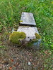
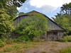
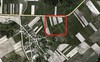
The above images may not be of the site on this page, but were taken nearby. They are loaded from Flickr so please click on them for image credits.
Click here to see more info for this site
Nearby sites
Click here to view sites on an interactive map of the areaKey: Red: member's photo, Blue: 3rd party photo, Yellow: other image, Green: no photo - please go there and take one, Grey: site destroyed
Download sites to:
KML (Google Earth)
GPX (GPS waypoints)
CSV (Garmin/Navman)
CSV (Excel)
To unlock full downloads you need to sign up as a Contributory Member. Otherwise downloads are limited to 50 sites.
Turn off the page maps and other distractions
Nearby sites listing. In the following links * = Image available
11.1km E 83° Mantviliškų akmuo* Natural Stone / Erratic / Other Natural Feature
25.5km W 276° Perlojos akmuo* Marker Stone
50.7km NE 42° Marijampolio akmuo* Natural Stone / Erratic / Other Natural Feature
51.6km W 280° Didysis Dzūkijos akmuo* Natural Stone / Erratic / Other Natural Feature
61.4km WSW 248° Velnio akmuo* Natural Stone / Erratic / Other Natural Feature
65.1km NNW 345° Girelių akmuo* Natural Stone / Erratic / Other Natural Feature
78.8km WNW 294° Riečių piliakalnis* Artificial Mound
79.1km N 355° Zasliai Footprint Stone* Rock Art
80.0km N 355° Laukagalio akmuo su dubenėliais* Rock Art
81.7km WNW 298° Gudelių akmuo* Natural Stone / Erratic / Other Natural Feature
82.1km WNW 289° Bambininkų piliakalnis* Artificial Mound
82.6km WNW 300° Šakališkių piliakalnis* Artificial Mound
88.6km WNW 292° Varnupių piliakalnis* Artificial Mound
88.6km WNW 292° Varnupių akmuo* Natural Stone / Erratic / Other Natural Feature
91.0km NNE 32° Nemenčinės Bilith* Modern Stone Circle etc
94.5km W 261° Grodzisko Posejnele Hillfort
94.8km WNW 292° Padovinio piliakalnis* Artificial Mound
98.6km NW 323° Santakos parkas* Modern Stone Circle etc
106.1km N 353° Juozapavos akmuo* Natural Stone / Erratic / Other Natural Feature
117.6km N 359° Ukmergės piliakalnis* Artificial Mound
118.7km W 268° Grodzisko Osinki Hillfort
120.6km W 272° Kurhan Wołownia Round Barrow(s)
120.9km W 270° Kurhany Prudziszki (2) Barrow Cemetery
122.1km W 269° Kurhany Prudziszki (1) Barrow Cemetery
124.7km W 273° Grodzisko Szurpiły* Hillfort
View more nearby sites and additional images


 We would like to know more about this location. Please feel free to add a brief description and any relevant information in your own language.
 Wir möchten mehr über diese Stätte erfahren. Bitte zögern Sie nicht, eine kurze Beschreibung und relevante Informationen in Deutsch hinzuzufügen.
 Nous aimerions en savoir encore un peu sur les lieux. S'il vous plaît n'hesitez pas à ajouter une courte description et tous les renseignements pertinents dans votre propre langue.
 Quisieramos informarnos un poco más de las lugares. No dude en añadir una breve descripción y otros datos relevantes en su propio idioma.