<< Our Photo Pages >> Blue Springs of Saula - Holy Well or Sacred Spring in Estonia
Submitted by Lorienc on Sunday, 19 August 2018 Page Views: 2292
Springs and Holy WellsSite Name: Blue Springs of Saula Alternative Name: Saula SiniallikadCountry: Estonia
NOTE: This site is 75.992 km away from the location you searched for.
Type: Holy Well or Sacred Spring
Nearest Village: Saula
Latitude: 59.215000N Longitude: 25.042778E
Condition:
| 5 | Perfect |
| 4 | Almost Perfect |
| 3 | Reasonable but with some damage |
| 2 | Ruined but still recognisable as an ancient site |
| 1 | Pretty much destroyed, possibly visible as crop marks |
| 0 | No data. |
| -1 | Completely destroyed |
| 5 | Superb |
| 4 | Good |
| 3 | Ordinary |
| 2 | Not Good |
| 1 | Awful |
| 0 | No data. |
| 5 | Can be driven to, probably with disabled access |
| 4 | Short walk on a footpath |
| 3 | Requiring a bit more of a walk |
| 2 | A long walk |
| 1 | In the middle of nowhere, a nightmare to find |
| 0 | No data. |
| 5 | co-ordinates taken by GPS or official recorded co-ordinates |
| 4 | co-ordinates scaled from a detailed map |
| 3 | co-ordinates scaled from a bad map |
| 2 | co-ordinates of the nearest village |
| 1 | co-ordinates of the nearest town |
| 0 | no data |
Internal Links:
External Links:
")
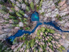
Approaching the springs from the road, the first one appearing is the deepest with the depth of 4 metres. Other two are 2 metres deep. On the bottom of the most distant one from the road about 30 minor springs in the form of sandy spots constantly changing the shapes and sizes can be counted. The mineral matter suspended near the bottom determines the colour of the springs. The springs discharge water with the all-year-round temperature of 5 ºC into the Pirita River. The surroundings of the springs freeze only in very harsh winters. The spring water has been described as having remedial power to heal eyes.
https://www.visitestonia.com/en/blue-springs-of-saula-sacrifical-springs
You may be viewing yesterday's version of this page. To see the most up to date information please register for a free account.
")
")
Do not use the above information on other web sites or publications without permission of the contributor.
Nearby Images from Flickr
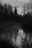
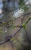
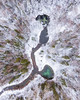
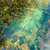
The above images may not be of the site on this page, but were taken nearby. They are loaded from Flickr so please click on them for image credits.
Click here to see more info for this site
Nearby sites
Click here to view sites on an interactive map of the areaKey: Red: member's photo, Blue: 3rd party photo, Yellow: other image, Green: no photo - please go there and take one, Grey: site destroyed
Download sites to:
KML (Google Earth)
GPX (GPS waypoints)
CSV (Garmin/Navman)
CSV (Excel)
To unlock full downloads you need to sign up as a Contributory Member. Otherwise downloads are limited to 50 sites.
Turn off the page maps and other distractions
Nearby sites listing. In the following links * = Image available
23.7km N 9° Kostivere Sliding Stone* Natural Stone / Erratic / Other Natural Feature
25.6km NNE 12° Jõelähtme* Barrow Cemetery
26.9km NNW 328° Linda Kivi* Natural Stone / Erratic / Other Natural Feature
27.4km N 5° Rebala* Barrow Cemetery
34.2km NE 40° Lauritsakivi* Natural Stone / Erratic / Other Natural Feature
35.2km NNE 25° Augusuurkivi* Natural Stone / Erratic / Other Natural Feature
41.2km NE 40° Hundikangrud* Cist
58.2km NE 48° Tammispea rändrahn* Natural Stone / Erratic / Other Natural Feature
59.5km NE 44° Jaani-Tooma Suurkivi* Natural Stone / Erratic / Other Natural Feature
64.5km NE 49° Saadumetsa suurkivi* Natural Stone / Erratic / Other Natural Feature
80.8km ENE 59° Kaarnakivi* Natural Stone / Erratic / Other Natural Feature
95.1km ENE 66° Ehalkivi* Natural Stone / Erratic / Other Natural Feature
106.9km N 357° National Museum of Finland Museum
107.4km SE 125° Kalevipoja lingukivi* Natural Stone / Erratic / Other Natural Feature
107.6km N 354° Pronssikautinen hauta Lehtisaari (2)* Cairn
107.8km N 355° Pronssikautinen hauta Lehtisaari (1)* Cairn
108.4km N 356° Pronssikautinen hauta Meilahti (1)* Cairn
111.3km N 357° Käpylä Hiidenkirnu* Natural Stone / Erratic / Other Natural Feature
113.9km N 359° Pihlajamäki Hiidenkirnu Natural Stone / Erratic / Other Natural Feature
130.0km E 95° Iisaku Muuseum* Museum
133.7km SE 133° Toomemäe ohvrikivi* Holed Stone
144.0km NE 48° Megaliths of Hogland Island* Standing Stones
147.9km W 262° Kootsaare Labyrinth Turf Maze
152.1km NW 316° Lupaja* Barrow Cemetery
164.0km NNE 29° Ahvenkoski Harbour Ancient Village or Settlement
View more nearby sites and additional images


 We would like to know more about this location. Please feel free to add a brief description and any relevant information in your own language.
 Wir möchten mehr über diese Stätte erfahren. Bitte zögern Sie nicht, eine kurze Beschreibung und relevante Informationen in Deutsch hinzuzufügen.
 Nous aimerions en savoir encore un peu sur les lieux. S'il vous plaît n'hesitez pas à ajouter une courte description et tous les renseignements pertinents dans votre propre langue.
 Quisieramos informarnos un poco más de las lugares. No dude en añadir una breve descripción y otros datos relevantes en su propio idioma.