<< Our Photo Pages >> Perlojos akmuo - Marker Stone in Lithuania
Submitted by Alta-Falisa on Wednesday, 23 September 2015 Page Views: 1408
Multi-periodSite Name: Perlojos akmuoCountry: Lithuania
NOTE: This site is 27.236 km away from the location you searched for.
Type: Marker Stone
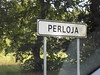
Nearest Town: Druskininkai Nearest Village: Perloja
Latitude: 54.217230N Longitude: 24.412860E
Condition:
| 5 | Perfect |
| 4 | Almost Perfect |
| 3 | Reasonable but with some damage |
| 2 | Ruined but still recognisable as an ancient site |
| 1 | Pretty much destroyed, possibly visible as crop marks |
| 0 | No data. |
| -1 | Completely destroyed |
| 5 | Superb |
| 4 | Good |
| 3 | Ordinary |
| 2 | Not Good |
| 1 | Awful |
| 0 | No data. |
| 5 | Can be driven to, probably with disabled access |
| 4 | Short walk on a footpath |
| 3 | Requiring a bit more of a walk |
| 2 | A long walk |
| 1 | In the middle of nowhere, a nightmare to find |
| 0 | No data. |
| 5 | co-ordinates taken by GPS or official recorded co-ordinates |
| 4 | co-ordinates scaled from a detailed map |
| 3 | co-ordinates scaled from a bad map |
| 2 | co-ordinates of the nearest village |
| 1 | co-ordinates of the nearest town |
| 0 | no data |
Internal Links:
External Links:
")
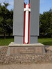
A boulder utilized to bear the coat of arms of Perloja (which was missing as recently as 2013 but has been replaced since then), and the still clearly legible date 1792. The coat of arms was the subject of a 80-centai stamp in 1994.
The boulder now stands on the lawn of a disused building, obviously not at its original place, and set upright on a recent concrete base. No information on site.
In 1792, a war between Poland and Russia took place over a vast area which included present day's Eastern Lithuania. One of its consequences was the end of the long standing Polish-Lithuanian Commonwealth.
Also in 1792, the town of Perloja was granted the Magdeburg Rights (Magdeburg Rights).
Easily accessible by the A4, which links the capital Vilnius to the famous spa resort Druskininkai. But you would overlook it if you didn't know about it.
Visited June 2015.
You may be viewing yesterday's version of this page. To see the most up to date information please register for a free account.
")
")
Do not use the above information on other web sites or publications without permission of the contributor.
Nearby Images from Flickr
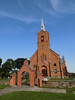


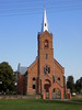
The above images may not be of the site on this page, but were taken nearby. They are loaded from Flickr so please click on them for image credits.
Click here to see more info for this site
Nearby sites
Click here to view sites on an interactive map of the areaKey: Red: member's photo, Blue: 3rd party photo, Yellow: other image, Green: no photo - please go there and take one, Grey: site destroyed
Download sites to:
KML (Google Earth)
GPX (GPS waypoints)
CSV (Garmin/Navman)
CSV (Excel)
To unlock full downloads you need to sign up as a Contributory Member. Otherwise downloads are limited to 50 sites.
Turn off the page maps and other distractions
Nearby sites listing. In the following links * = Image available
25.5km E 96° Kalesninkų akmuo* Standing Stone (Menhir)
26.2km WNW 284° Didysis Dzūkijos akmuo* Natural Stone / Erratic / Other Natural Feature
36.3km E 92° Mantviliškų akmuo* Natural Stone / Erratic / Other Natural Feature
40.8km SW 231° Velnio akmuo* Natural Stone / Erratic / Other Natural Feature
55.1km WNW 302° Riečių piliakalnis* Artificial Mound
57.5km WNW 294° Bambininkų piliakalnis* Artificial Mound
58.7km NW 306° Gudelių akmuo* Natural Stone / Erratic / Other Natural Feature
60.0km NW 309° Šakališkių piliakalnis* Artificial Mound
60.8km N 8° Girelių akmuo* Natural Stone / Erratic / Other Natural Feature
64.5km WNW 298° Varnupių piliakalnis* Artificial Mound
64.5km WNW 298° Varnupių akmuo* Natural Stone / Erratic / Other Natural Feature
68.6km ENE 59° Marijampolio akmuo* Natural Stone / Erratic / Other Natural Feature
70.2km WSW 256° Grodzisko Posejnele Hillfort
70.7km WNW 298° Padovinio piliakalnis* Artificial Mound
78.4km NNE 14° Zasliai Footprint Stone* Rock Art
78.9km NNE 13° Laukagalio akmuo su dubenėliais* Rock Art
83.2km NNW 336° Santakos parkas* Modern Stone Circle etc
93.6km W 266° Grodzisko Osinki Hillfort
95.2km W 270° Kurhan Wołownia Round Barrow(s)
95.6km W 268° Kurhany Prudziszki (2) Barrow Cemetery
96.9km W 267° Kurhany Prudziszki (1) Barrow Cemetery
99.3km W 272° Grodzisko Szurpiły* Hillfort
103.1km N 6° Juozapavos akmuo* Natural Stone / Erratic / Other Natural Feature
103.9km WNW 297° Vilkaviškio krašto akmuo* Marker Stone
104.4km NE 44° Nemenčinės Bilith* Modern Stone Circle etc
View more nearby sites and additional images


 We would like to know more about this location. Please feel free to add a brief description and any relevant information in your own language.
 Wir möchten mehr über diese Stätte erfahren. Bitte zögern Sie nicht, eine kurze Beschreibung und relevante Informationen in Deutsch hinzuzufügen.
 Nous aimerions en savoir encore un peu sur les lieux. S'il vous plaît n'hesitez pas à ajouter une courte description et tous les renseignements pertinents dans votre propre langue.
 Quisieramos informarnos un poco más de las lugares. No dude en añadir una breve descripción y otros datos relevantes en su propio idioma.