

<< Our Photo Pages >> Velatouri Mycenaean Tholos 1 - Cairn in Greece in Central Greece
Submitted by AlexHunger on Monday, 30 October 2006 Page Views: 4758
Neolithic and Bronze AgeSite Name: Velatouri Mycenaean Tholos 1Country: Greece
NOTE: This site is 3.699 km away from the location you searched for.
Region: Central Greece Type: Cairn
Nearest Town: Athens Nearest Village: Thorikos
Latitude: 37.742146N Longitude: 24.056060E
Condition:
| 5 | Perfect |
| 4 | Almost Perfect |
| 3 | Reasonable but with some damage |
| 2 | Ruined but still recognisable as an ancient site |
| 1 | Pretty much destroyed, possibly visible as crop marks |
| 0 | No data. |
| -1 | Completely destroyed |
| 5 | Superb |
| 4 | Good |
| 3 | Ordinary |
| 2 | Not Good |
| 1 | Awful |
| 0 | No data. |
| 5 | Can be driven to, probably with disabled access |
| 4 | Short walk on a footpath |
| 3 | Requiring a bit more of a walk |
| 2 | A long walk |
| 1 | In the middle of nowhere, a nightmare to find |
| 0 | No data. |
| 5 | co-ordinates taken by GPS or official recorded co-ordinates |
| 4 | co-ordinates scaled from a detailed map |
| 3 | co-ordinates scaled from a bad map |
| 2 | co-ordinates of the nearest village |
| 1 | co-ordinates of the nearest town |
| 0 | no data |
Internal Links:
External Links:
")
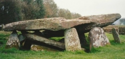
The Velatouri hill is the centre of a Mycenaean settlement and the later ancient deme of Thorikos. The Mycenaean acropolis on the top of the Velatouri hill and the two tholos tombs of the same period. The first excavations were carried out in 1820.
You may be viewing yesterday's version of this page. To see the most up to date information please register for a free account.
")
")
")
")
Do not use the above information on other web sites or publications without permission of the contributor.
Nearby Images from Flickr


The above images may not be of the site on this page, but were taken nearby. They are loaded from Flickr so please click on them for image credits.
Click here to see more info for this site
Nearby sites
Click here to view sites on an interactive map of the areaKey: Red: member's photo, Blue: 3rd party photo, Yellow: other image, Green: no photo - please go there and take one, Grey: site destroyed
Download sites to:
KML (Google Earth)
GPX (GPS waypoints)
CSV (Garmin/Navman)
CSV (Excel)
To unlock full downloads you need to sign up as a Contributory Member. Otherwise downloads are limited to 50 sites.
Turn off the page maps and other distractions
Nearby sites listing. In the following links * = Image available
116m S 189° Velatouri Hill Acropolis Ancient Temple
217m SE 135° Velatouri Mycenaean Tholos 2 Cairn
519m SSW 205° Velatouri Settlement* Ancient Village or Settlement
5.0km W 259° Kitsos Cave Cave or Rock Shelter
10.2km SSW 194° Sounion Temple of Athena* Ancient Temple
10.6km SSW 195° Sounion Temple of Poseidon* Ancient Temple
20.9km NNW 346° Vravrona Museum* Museum
21.1km NNW 345° Vravrona Tomb of Iphigenia* Chambered Cairn
21.2km NNW 345° Vravrona Temple of Artemis* Ancient Temple
26.7km N 351° Temple of Artemis Tauropolos* Ancient Temple
27.1km WNW 301° Cave of Nympholyptou* Cave or Rock Shelter
29.8km N 354° Askitario* Ancient Village or Settlement
31.4km SE 130° Karthea Temple* Ancient Village or Settlement
37.9km NW 313° Cycladic Museum at Athens* Museum
37.9km NW 312° Temple of Olympian Zeus* Ancient Temple
38.3km NW 311° New Acropolis Museum* Museum
38.4km NW 311° Theatre of Dionysus* Ancient Temple
38.5km NW 312° Acropolis Museum* Museum
38.6km NW 312° Acropolis* Hillfort
38.6km NW 311° Parthenon* Ancient Temple
38.6km NW 312° Erechteion* Ancient Temple
38.7km NW 311° Odeon Of Herodes Atticus* Ancient Village or Settlement
38.7km NW 311° Propylaia* Ancient Temple
39.2km NW 312° Temple of Hephaestos* Ancient Temple
39.5km NW 314° National Archaeological Museum Athens* Museum
View more nearby sites and additional images


 We would like to know more about this location. Please feel free to add a brief description and any relevant information in your own language.
 Wir möchten mehr über diese Stätte erfahren. Bitte zögern Sie nicht, eine kurze Beschreibung und relevante Informationen in Deutsch hinzuzufügen.
 Nous aimerions en savoir encore un peu sur les lieux. S'il vous plaît n'hesitez pas à ajouter une courte description et tous les renseignements pertinents dans votre propre langue.
 Quisieramos informarnos un poco más de las lugares. No dude en añadir una breve descripción y otros datos relevantes en su propio idioma.