

<< Our Photo Pages >> Bambininkų piliakalnis - Artificial Mound in Lithuania
Submitted by Alta-Falisa on Thursday, 24 September 2015 Page Views: 1135
Multi-periodSite Name: Bambininkų piliakalnis Alternative Name: Dembavaragio piliakalnisCountry: Lithuania
NOTE: This site is 17.251 km away from the location you searched for.
Type: Artificial Mound
Nearest Town: Alytus Nearest Village: Ąžuoliniai
Latitude: 54.428100N Longitude: 23.603500E
Condition:
| 5 | Perfect |
| 4 | Almost Perfect |
| 3 | Reasonable but with some damage |
| 2 | Ruined but still recognisable as an ancient site |
| 1 | Pretty much destroyed, possibly visible as crop marks |
| 0 | No data. |
| -1 | Completely destroyed |
| 5 | Superb |
| 4 | Good |
| 3 | Ordinary |
| 2 | Not Good |
| 1 | Awful |
| 0 | No data. |
| 5 | Can be driven to, probably with disabled access |
| 4 | Short walk on a footpath |
| 3 | Requiring a bit more of a walk |
| 2 | A long walk |
| 1 | In the middle of nowhere, a nightmare to find |
| 0 | No data. |
| 5 | co-ordinates taken by GPS or official recorded co-ordinates |
| 4 | co-ordinates scaled from a detailed map |
| 3 | co-ordinates scaled from a bad map |
| 2 | co-ordinates of the nearest village |
| 1 | co-ordinates of the nearest town |
| 0 | no data |
Internal Links:
External Links:
")
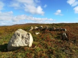
Artificial mound dated late 1st millennium - early 2nd millennium AD.
It derives its name from being built on the left bank of the small Bambena river, which flows at its foot to the North (this photo shows the southern slope).
Several versions of a legend linger around this mound, implying that Demburis, the last Worshipper of the Thunder, would be be buried hereunder. Hence its alternate name : Dembavaragio piliakalnis, sometimes (erroneously) spelled Dambavaragio piliakalnis.
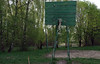
Recently (after July 2012) signposted along road 1112, at (54.4281,23.6014).
A stair allows to climb to the top.
Information board at the foot of the mound.
More general information about Piliakalniai (plural of Piliakalnis) : Piliakalniai.
You may be viewing yesterday's version of this page. To see the most up to date information please register for a free account.
")
")
")
")
Do not use the above information on other web sites or publications without permission of the contributor.
Nearby Images from Flickr

The above images may not be of the site on this page, but were taken nearby. They are loaded from Flickr so please click on them for image credits.
Click here to see more info for this site
Nearby sites
Click here to view sites on an interactive map of the areaKey: Red: member's photo, Blue: 3rd party photo, Yellow: other image, Green: no photo - please go there and take one, Grey: site destroyed
Download sites to:
KML (Google Earth)
GPX (GPS waypoints)
CSV (Garmin/Navman)
CSV (Excel)
To unlock full downloads you need to sign up as a Contributory Member. Otherwise downloads are limited to 50 sites.
Turn off the page maps and other distractions
Nearby sites listing. In the following links * = Image available
7.7km NE 45° Riečių piliakalnis* Artificial Mound
8.1km NW 326° Varnupių akmuo* Natural Stone / Erratic / Other Natural Feature
8.2km NNW 327° Varnupių piliakalnis* Artificial Mound
12.1km NNE 24° Gudelių akmuo* Natural Stone / Erratic / Other Natural Feature
13.7km NW 311° Padovinio piliakalnis* Artificial Mound
15.0km NNE 21° Šakališkių piliakalnis* Artificial Mound
32.1km ESE 122° Didysis Dzūkijos akmuo* Natural Stone / Erratic / Other Natural Feature
44.2km SSW 200° Grodzisko Posejnele Hillfort
46.6km WNW 300° Vilkaviškio krašto akmuo* Marker Stone
49.1km WSW 240° Kurhan Wołownia Round Barrow(s)
51.3km WSW 237° Kurhany Prudziszki (2) Barrow Cemetery
51.3km SW 232° Grodzisko Osinki Hillfort
51.3km WSW 245° Grodzisko Szurpiły* Hillfort
52.8km WSW 237° Kurhany Prudziszki (1) Barrow Cemetery
53.6km SSE 157° Velnio akmuo* Natural Stone / Erratic / Other Natural Feature
55.2km NNE 19° Santakos parkas* Modern Stone Circle etc
57.5km ESE 114° Perlojos akmuo* Marker Stone
58.3km W 275° Vištyčio akmuo* Natural Stone / Erratic / Other Natural Feature
60.1km NW 308° Lithuanian Millenium Stone* Modern Stone Circle etc
71.0km ENE 58° Girelių akmuo* Natural Stone / Erratic / Other Natural Feature
71.5km WSW 253° Grodzisko Gulberek* Hillfort
79.0km N 4° Karalgirio akmuo* Natural Stone / Erratic / Other Natural Feature
82.1km ESE 108° Kalesninkų akmuo* Standing Stone (Menhir)
87.8km NE 52° Laukagalio akmuo su dubenėliais* Rock Art
88.2km NE 53° Zasliai Footprint Stone* Rock Art
View more nearby sites and additional images


 We would like to know more about this location. Please feel free to add a brief description and any relevant information in your own language.
 Wir möchten mehr über diese Stätte erfahren. Bitte zögern Sie nicht, eine kurze Beschreibung und relevante Informationen in Deutsch hinzuzufügen.
 Nous aimerions en savoir encore un peu sur les lieux. S'il vous plaît n'hesitez pas à ajouter une courte description et tous les renseignements pertinents dans votre propre langue.
 Quisieramos informarnos un poco más de las lugares. No dude en añadir una breve descripción y otros datos relevantes en su propio idioma.