

<< Our Photo Pages >> Zaječar museum - Museum in Serbia
Submitted by Armand on Monday, 07 January 2019 Page Views: 1031
MuseumsSite Name: Zaječar museumCountry: Serbia
NOTE: This site is 54.745 km away from the location you searched for.
Type: Museum
Nearest Town: Zaječar
Latitude: 43.903500N Longitude: 22.278700E
Condition:
| 5 | Perfect |
| 4 | Almost Perfect |
| 3 | Reasonable but with some damage |
| 2 | Ruined but still recognisable as an ancient site |
| 1 | Pretty much destroyed, possibly visible as crop marks |
| 0 | No data. |
| -1 | Completely destroyed |
| 5 | Superb |
| 4 | Good |
| 3 | Ordinary |
| 2 | Not Good |
| 1 | Awful |
| 0 | No data. |
| 5 | Can be driven to, probably with disabled access |
| 4 | Short walk on a footpath |
| 3 | Requiring a bit more of a walk |
| 2 | A long walk |
| 1 | In the middle of nowhere, a nightmare to find |
| 0 | No data. |
| 5 | co-ordinates taken by GPS or official recorded co-ordinates |
| 4 | co-ordinates scaled from a detailed map |
| 3 | co-ordinates scaled from a bad map |
| 2 | co-ordinates of the nearest village |
| 1 | co-ordinates of the nearest town |
| 0 | no data |
Internal Links:
External Links:
")
Web Site: http://directory.serbia.com/item/national-museum-zajecar/
You may be viewing yesterday's version of this page. To see the most up to date information please register for a free account.
")
")
")
Do not use the above information on other web sites or publications without permission of the contributor.
Nearby Images from Flickr
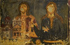
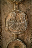
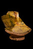
The above images may not be of the site on this page, but were taken nearby. They are loaded from Flickr so please click on them for image credits.
Click here to see more info for this site
Nearby sites
Click here to view sites on an interactive map of the areaKey: Red: member's photo, Blue: 3rd party photo, Yellow: other image, Green: no photo - please go there and take one, Grey: site destroyed
Download sites to:
KML (Google Earth)
GPX (GPS waypoints)
CSV (Garmin/Navman)
CSV (Excel)
To unlock full downloads you need to sign up as a Contributory Member. Otherwise downloads are limited to 50 sites.
Turn off the page maps and other distractions
Nearby sites listing. In the following links * = Image available
7.7km W 266° Felix Romuliana* Ancient Palace
52.7km NNW 341° Rudna Glava Ancient Mine, Quarry or other Industry
64.9km SSW 194° Balanica Cave Cave or Rock Shelter
70.1km W 267° Zavičajni Muzej Paraćin* Museum
72.1km SSW 206° Narodni muzej Niš* Museum
75.4km NNW 345° Lepenski Vir* Ancient Village or Settlement
82.0km N 1° The face of Dacian King Decebalus* Sculptured Stone
83.9km N 2° Tabula Traiana* Carving
84.5km NNE 18° Schela Cladovei* Ancient Village or Settlement
84.7km WSW 245° Narodni Muzej Kruševac* Museum
85.8km NNE 21° Trajan's Roman Bridge* Ancient Trackway
94.4km NNW 333° Chindiei 2 Cave* Rock Art
104.0km WNW 284° Grncarica Ancient Village or Settlement
106.6km SW 224° Pločnik* Ancient Village or Settlement
119.0km SSW 208° Caričin Grad* Ancient Village or Settlement
124.4km NW 318° Viminacium* Ancient Village or Settlement
130.7km ESE 116° Ohoden-Valoga Ancient Village or Settlement
133.7km SSE 160° Sacred Nuraghe Well (Garlo)* Holy Well or Sacred Spring
141.5km W 269° Mrcajevci Barrow Cemetery
151.0km NNE 26° Priest's Cave* Rock Art
151.4km S 190° Maniste Necropolis* Barrow Cemetery
152.2km SSE 155° Krivi Kamik* Hillfort
154.5km E 80° Olt Burial Site Round Cairn
158.7km SSE 147° National Archaeological Museum of Bulgaria* Museum
162.6km NW 307° Vinca Belo Brdo* Ancient Village or Settlement
View more nearby sites and additional images


 We would like to know more about this location. Please feel free to add a brief description and any relevant information in your own language.
 Wir möchten mehr über diese Stätte erfahren. Bitte zögern Sie nicht, eine kurze Beschreibung und relevante Informationen in Deutsch hinzuzufügen.
 Nous aimerions en savoir encore un peu sur les lieux. S'il vous plaît n'hesitez pas à ajouter une courte description et tous les renseignements pertinents dans votre propre langue.
 Quisieramos informarnos un poco más de las lugares. No dude en añadir una breve descripción y otros datos relevantes en su propio idioma.