<< Our Photo Pages >> Kolkasrags, Jūras Panemtiem - Modern Stone Circle etc in Latvia
Submitted by Alta-Falisa on Thursday, 02 April 2015 Page Views: 3530
Modern SitesSite Name: Kolkasrags, Jūras Panemtiem Alternative Name: Cape Kolka, Monument to the Victims of the SeaCountry: Latvia
NOTE: This site is 66.766 km away from the location you searched for.
Type: Modern Stone Circle etc
Nearest Town: Kolka
Latitude: 57.757800N Longitude: 22.602200E
Condition:
| 5 | Perfect |
| 4 | Almost Perfect |
| 3 | Reasonable but with some damage |
| 2 | Ruined but still recognisable as an ancient site |
| 1 | Pretty much destroyed, possibly visible as crop marks |
| 0 | No data. |
| -1 | Completely destroyed |
| 5 | Superb |
| 4 | Good |
| 3 | Ordinary |
| 2 | Not Good |
| 1 | Awful |
| 0 | No data. |
| 5 | Can be driven to, probably with disabled access |
| 4 | Short walk on a footpath |
| 3 | Requiring a bit more of a walk |
| 2 | A long walk |
| 1 | In the middle of nowhere, a nightmare to find |
| 0 | No data. |
| 5 | co-ordinates taken by GPS or official recorded co-ordinates |
| 4 | co-ordinates scaled from a detailed map |
| 3 | co-ordinates scaled from a bad map |
| 2 | co-ordinates of the nearest village |
| 1 | co-ordinates of the nearest town |
| 0 | no data |
Internal Links:
External Links:
")
This remote, unspoiled location, off the beaten tracks, offers windswept white sand beaches and a wild coastline, and is mainly visited by people who came on purpose.
You may be viewing yesterday's version of this page. To see the most up to date information please register for a free account.
Do not use the above information on other web sites or publications without permission of the contributor.
Nearby Images from Flickr

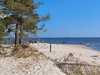


The above images may not be of the site on this page, but were taken nearby. They are loaded from Flickr so please click on them for image credits.
Click here to see more info for this site
Nearby sites
Click here to view sites on an interactive map of the areaKey: Red: member's photo, Blue: 3rd party photo, Yellow: other image, Green: no photo - please go there and take one, Grey: site destroyed
Download sites to:
KML (Google Earth)
GPX (GPS waypoints)
CSV (Garmin/Navman)
CSV (Excel)
To unlock full downloads you need to sign up as a Contributory Member. Otherwise downloads are limited to 50 sites.
Turn off the page maps and other distractions
Nearby sites listing. In the following links * = Image available
45.9km S 171° Vandzenes akmens (Stone of Vandzene)* Natural Stone / Erratic / Other Natural Feature
121.3km SW 221° Ulmales upurakmens* Rock Art
127.0km SE 134° Latvian National History Museum* Museum
127.3km SE 134° Stone Head of Salaspils* Sculptured Stone
127.4km SE 134° Stone Head of Salaspils replica* Modern Stone Circle etc
135.0km SSE 168° Pokaini Forest* Ancient Village or Settlement
138.3km N 357° Kootsaare Labyrinth Turf Maze
145.4km SSW 196° Meldzeres dobumakmens* Holed Stone
148.0km SSW 197° Vībiņi akmens* Marker Stone
148.9km ESE 115° Turaida Engraved Stone* Natural Stone / Erratic / Other Natural Feature
149.8km ESE 115° Sigulda Pils* Modern Stone Circle etc
151.6km S 186° Vadakstes Valdnieku* Modern Stone Circle etc
155.8km E 94° Davini Great stone (Daviņu Lielais akmens)* Rock Art
157.4km SW 215° Kapsēdes Rudais akmens* Rock Art
158.3km SW 215° Kapsēdes dižakmens* Marker Stone
160.8km SSW 213° Grobina Barrow Cemetery
177.1km SSW 199° Apuolės piliakalnis* Artificial Mound
179.3km ESE 111° Ūdri (Pūķi) cross stone* Ancient Cross
179.4km SSW 194° Barstyčių akmuo* Natural Stone / Erratic / Other Natural Feature
183.2km SSW 203° Luknių akmuo* Natural Stone / Erratic / Other Natural Feature
186.7km SSW 191° Žemaičių Kalvarija* Holed Stone
187.7km SSW 200° Mosėdis akmenų muziejus* Museum
188.6km S 184° Virmėnų akmuo* Modern Stone Circle etc
189.1km SSW 200° Šilalės Aukuro akmuo* Holed Stone
189.1km SSW 200° Šilalės Didysis akmuo* Natural Stone / Erratic / Other Natural Feature
View more nearby sites and additional images


 We would like to know more about this location. Please feel free to add a brief description and any relevant information in your own language.
 Wir möchten mehr über diese Stätte erfahren. Bitte zögern Sie nicht, eine kurze Beschreibung und relevante Informationen in Deutsch hinzuzufügen.
 Nous aimerions en savoir encore un peu sur les lieux. S'il vous plaît n'hesitez pas à ajouter une courte description et tous les renseignements pertinents dans votre propre langue.
 Quisieramos informarnos un poco más de las lugares. No dude en añadir una breve descripción y otros datos relevantes en su propio idioma.