<< Our Photo Pages >> Grodzisko Naszacowice - Hillfort in Poland in Malopolskie
Submitted by SolarMegalith on Monday, 22 September 2014 Page Views: 1756
Early Medieval (Dark Age)Site Name: Grodzisko NaszacowiceCountry: Poland
NOTE: This site is 34.995 km away from the location you searched for.
Voivodeship: Malopolskie Type: Hillfort
Nearest Town: Nowy Sącz
Latitude: 49.548972N Longitude: 20.563576E
Condition:
| 5 | Perfect |
| 4 | Almost Perfect |
| 3 | Reasonable but with some damage |
| 2 | Ruined but still recognisable as an ancient site |
| 1 | Pretty much destroyed, possibly visible as crop marks |
| 0 | No data. |
| -1 | Completely destroyed |
| 5 | Superb |
| 4 | Good |
| 3 | Ordinary |
| 2 | Not Good |
| 1 | Awful |
| 0 | No data. |
| 5 | Can be driven to, probably with disabled access |
| 4 | Short walk on a footpath |
| 3 | Requiring a bit more of a walk |
| 2 | A long walk |
| 1 | In the middle of nowhere, a nightmare to find |
| 0 | No data. |
| 5 | co-ordinates taken by GPS or official recorded co-ordinates |
| 4 | co-ordinates scaled from a detailed map |
| 3 | co-ordinates scaled from a bad map |
| 2 | co-ordinates of the nearest village |
| 1 | co-ordinates of the nearest town |
| 0 | no data |
Internal Links:
External Links:
I have visited· I would like to visit
SolarMegalith visited on 26th Aug 2014 - their rating: Cond: 4 Amb: 3 Access: 4
")
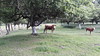
One of the largest and best studied hillforts of southern Poland is located on the top of a hill over the village of Naszacowice. It covers the area of 15ha and has been built in four phases - the earliest one dates back to 8th century AD (tribal period in Poland), the final one to the late 10th century AD.
The main hillfort is a circular structure with a well-preserved rampart and ditch - originally the earthwork was up to 10.5m high (measuring from the bottom of the ditch). Adjacent to the fort is a large enclosed settlement, particularly extensive at the south.
You may be viewing yesterday's version of this page. To see the most up to date information please register for a free account.
")
")
")
")
Do not use the above information on other web sites or publications without permission of the contributor.
Nearby Images from Flickr
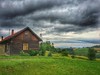
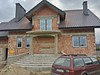
The above images may not be of the site on this page, but were taken nearby. They are loaded from Flickr so please click on them for image credits.
Click here to see more info for this site
Nearby sites
Click here to view sites on an interactive map of the areaKey: Red: member's photo, Blue: 3rd party photo, Yellow: other image, Green: no photo - please go there and take one, Grey: site destroyed
Download sites to:
KML (Google Earth)
GPX (GPS waypoints)
CSV (Garmin/Navman)
CSV (Excel)
To unlock full downloads you need to sign up as a Contributory Member. Otherwise downloads are limited to 50 sites.
Turn off the page maps and other distractions
Nearby sites listing. In the following links * = Image available
3.3km N 8° Grodzisko Grobla - Podegrodzie* Hillfort
6.8km W 273° Grodzisko Góra Zyndrama Hillfort
12.4km NE 34° Grodzisko Chełmiec* Hillfort
15.5km NNE 30° Grodzisko Marcinkowice* Hillfort
25.0km NNE 27° Grodzisko Małpia Wyspa* Hillfort
39.4km NNE 24° Grodzisko Zawada Lanckorońska* Hillfort
41.0km NNE 27° Grodzisko Roztoka* Promontory Fort / Cliff Castle
41.6km NW 316° Grodzisko Klasztorzysko* Hillfort
42.3km NW 315° Grodzisko Poznachowice Górne* Hillfort
44.3km N 8° Grodzisko Jadowniki Podgórne* Hillfort
49.0km NNW 344° Grodzisko Łapczyca Hillfort
51.7km NNW 334° Kurhan Krakuszowice Round Barrow(s)
52.3km NNW 329° Kurhany Jawczyce Barrow Cemetery
57.8km NNE 33° Grodzisko Zawada (Tarnów)* Hillfort
58.4km SSW 199° Podtatranské múzeum v Poprade* Museum
59.5km SW 218° Prehistoric Greeting* Burial Chamber or Dolmen
60.3km SSW 197° Gánovce 1* Ancient Village or Settlement
62.8km SSE 166° Spišský hrad* Ancient Village or Settlement
65.4km E 88° Grodzisko Walik - Brzezowa* Hillfort
65.7km ENE 72° Grodzisko Trzcinica* Hillfort
65.8km ENE 72° Trzcinica - Ekspozycja Archeologiczna* Museum
68.0km NNW 329° Kopiec Wandy* Artificial Mound
68.6km NE 54° Grodzisko Przeczyca* Hillfort
69.6km NW 322° Kopiec Krakusa* Artificial Mound
72.0km NW 321° Kraków - Wawel* Ancient Village or Settlement
View more nearby sites and additional images


 We would like to know more about this location. Please feel free to add a brief description and any relevant information in your own language.
 Wir möchten mehr über diese Stätte erfahren. Bitte zögern Sie nicht, eine kurze Beschreibung und relevante Informationen in Deutsch hinzuzufügen.
 Nous aimerions en savoir encore un peu sur les lieux. S'il vous plaît n'hesitez pas à ajouter une courte description et tous les renseignements pertinents dans votre propre langue.
 Quisieramos informarnos un poco más de las lugares. No dude en añadir una breve descripción y otros datos relevantes en su propio idioma.